21163102
Description
Quiz by Aaron Molinari, updated more than 1 year ago
|
|
Created by Aaron Molinari
about 4 years ago
|
|
Question 1
Question
Which air navigation service is the responsible to disseminate the instrument approach charts to the aircraft operators?
Answer
-
The airspace management (ASM) service.
-
The flight inforamtion service (FIS).
-
The aeronautical information service (AIS).
-
The aerodrome traffic zone (ATZ) service.
Question 2
Question
Which air navigation service is the responsible to disseminate the visual approach charts to the aircraft operators?
Answer
-
The airspace management (ASM) service.
-
The flight inforamtion service (FIS).
-
The aeronautical information service (AIS).
-
The aerodrome traffic zone (ATZ) service.
Question 3
Question
Which air navigation service is the responsible to disseminate the rules of the air that apply to a specific country?
Answer
-
The airspace management (ASM) service of the country.
-
The flight inforamtion service (FIS) of the country.
-
The aeronautical information service (AIS) of the country.
-
The aerodrome traffic zone (ATZ) services of the country.
Question 4
Question
What is a flight information region (FIR)?
Answer
-
A specified airspace assigned to one air traffic controller (or two if working in pairs) providing flight information services.
-
A specified airspace assigned to one air traffic controller (or two if working in pairs) providing alert services
-
A specified airspace in which flight information and alert services are provided. It is the largest regular division of airspace in use in the world today.
-
A specified airspace above an airfield where flight information is provided to aircraft in the airfield traffic pattern.
Question 5
Question
What is an upper information region (UIR)?
Answer
-
A FIR in the upper airspace.
-
A specified airspace above an airfield where flight information is provided to aircraft executing SIDs and STARs.
-
A specified airspace above an airfield where flight information is provided to aircraft executing approaches.
-
A specified airspace above an airfield where flight information is provided to aircraft in the airfield traffic pattern.
Question 6
Question
North Atlantic tracks (NAT) are...
Answer
-
the static airway network in the North Atlantic airspace.
-
an organised en-route track network that is updated every day as a function of the wind field forecast.
-
the set of actual trajectory tracks that have been flown by all aircraft crossing the North Atlantic in a given period of time and considering realised weather.
-
the name given to the oceanic clearances required to enter the North Atlantic airspace.
Question 7
Question
A VFR aircraft is cruising with heading 130o. According to the ICAO flight level allocation scheme (odd-even rule), a possible flight level for this flight could be:
Answer
-
FL130
-
FL135
-
FL140
-
IFR flights do not fly using flight levels, but Altitudes.
Question 8
Question
An IFR aircraft is cruising with heading 130o. According to the ICAO flight level allocation scheme (odd-even rule), a possible flight level for this flight could be:
Answer
-
FL130
-
FL135
-
FL140
-
IFR flights do not fly using flight levels, but Altitudes.
Question 9
Question
During a climb, when the pilot reaches the transition altitude, he/she shall...
Answer
-
change the altimeter setting from QNH to STD
-
change the altimeter setting from STD to QNH
-
change the altimeter setting from STD to QFE.
-
do nothing in particular regarding the altimeter setting.
Question 10
Question
A pilot is reporting ”our altitude is six thousand feet”. This means:
Answer
-
The barometric altimeter of the aircraft indicates 6000 ft and it is calibrated with respect to the standard pressure at sea level (1013.25 hPa).
-
The barometric altimeter of the aircraft indicates 6000 ft and it is calibrated with respect to the local QNH.
-
The radio altimeter of the aircraft indicates 6000 ft and it is calibrated with respect to the standard pressure at sea level (1013.25 hPa).
-
The radio altimeter of the aircraft indicates 6000 ft and it is calibrated with respect to the local QNH.
Question 11
Question
Why in standard instrumental departures carts maximum altitude restrictions for certain segments are typically indicated?
Answer
-
To allow visual self-separation procedures.
-
To allow continuous climb operations (CCO).
-
To strategically de-conflict them with arrivals crossing from below.
-
To strategically de-conflict them with arrivals crossing from above.
Question 12
Question
With our small VFR aircraft, which is NOT equipped with any VHF communications radio...
Answer
-
it is not legal to fly in civil airspace without a communications radio.
-
we can only fly in airspace G.
-
we can only fly in airspace F or G.
-
we can only fly in airspace E, F or G.
Question 13
Question
The ATZ typically encompasses...
Answer
-
the SIDs and STARs.
-
the instrumental approach procedures.
-
the visual airfield traffic pattern.
-
all the other answers are correct.
Question 14
Question
Which of the following controlled airspace zones is sized to accommodate, approximately, all the aircraft flying standard instrumental departures?
Answer
-
The ATZ.
-
The CTR.
-
The TMA.
-
The ATC.
Question 15
Question
Which of the following statements is correct when talking about free route airspace?
Answer
-
Within free route space the pilot can freely execute the flight between any entry and exit points, but must communicate the intentions to the air traffic control.
-
Within free route space the aircraft operator can freely plan routes between any entry and exit points, but must specify the chosen route in the flight plan.
-
Within free route space the air traffic controller can freely move aircraft from their planned routes by giving instructions (vectors) in order to expedite the flow of air traffic.
-
Within free route space the air traffic controller is not responsible to guarantee separation between aircraft and will only assist them in case of an emergency.
Question 16
Question
What is a TRA (temporary reserved area)?
Answer
-
a volume of airspace temporary reserved for IFR terminal manoeuvres where VFR traffic might transit under an ATC clearance
-
a volume of airspace temporary reserved for IFR terminal manoeuvres where VFR traffic cannot transit under any circumstance
-
a volume of airspace temporary reserved and allocated for specific use where civil traffic might transit under an ATC clearance.
-
a volume of airspace temporary reserved and allocated for specific use where civil traffic cannot transit under any circumstance.
Question 17
Question
Which of the following statements does NOT apply to the FUA concept?
Answer
-
Airspace segregations are not longer permanent and they are based on real use during conveniently chosen time periods.
-
Airspace should no longer be designated either military or civil.
-
Airspace should be considered as one continuum and used flexibly on a day-to-day basis.
-
All the other options apply to the FUA concept.
Question 18
Question
Regarding the flexible use of airspace (FUA) concept, the second level (pre-tactical level) deals with:
Answer
-
The definition of national airspace policy and predetermined airspace structures.
-
The day-to-day allocation of airspace, according to users requirements.
-
The real-time use and management of available airspace.
-
The definition of the sectorisation and capacity of the military airways.
Question 19
Question
What is the international radiotelephony urgency signal for aviation?
Answer
-
The word MayDay.
-
The word MayDay repeated three times.
-
The word Pan-Pan.
-
The word Pan-Pan repeated three times.
Question 20
Question
Which of the following transponder codes indicates distress?
Answer
-
1215
-
7500
-
7600
-
7700
Question 21
Question
An air traffic controller issues the following radiotelephony message: Echo Charlie Uniform Papa Charlie, traffic at your 10 o’clock position, Cessna 172 westbound at 4 miles, 300 ft below. Which of the following answers is correct?
Answer
-
The message is a separation instruction to prevent a midair collision.
-
It is a distress signal message.
-
It is a collision hazard flight information message.
-
It is a urgency signal message.
Question 22
Question
Which of the following summarises the three high-level tasks that are always performed by an air traffic controller?
Answer
-
Aviate, Navigate and Communicate.
-
Coordinate clearances with other ATC units, coordinate civil-military operations, coordinate emergencies.
-
Gather and process data from flights and/or ground vehicles, issue clearances, coordinate clearances with other ATC units.
-
Gather and process data from flights and/or ground vehicles, separate aircraft, give flight information instructions.
Question 23
Question
In which situation, the visual contact with aircraft is the main data gathering source for an air traffic controller?
Answer
-
for the IFR clearance delivery dependency.
-
for the ground movement control dependency.
-
for the approach control dependency
-
Nowadays, visual contact with aircraft is not used as source of information by ATC anymore.
Question 24
Question
Which of the following elements is not included in an IFR clearance delivery?
Answer
-
the route to follow.
-
the wind conditions for take-off.
-
the first transponder code (squawk) of the flight.
-
the initial altitude of the flight
Question 25
Question
North Atlantic control typically requires the aircraft crew to:
Answer
-
Report their position only when requested by the ATC.
-
Report periodically their position every 2h.
-
Report periodically their position every 10o of longitude.
-
Switch-off the transponder.
Question 26
Question
Imagine a ground ATC system equipped only with a SSR mode C radar. Which of the following statements is correct?
Answer
-
Aircraft calibrated airspeed can be inferred from radar data.
-
Aircraft true airspeed can be inferred from radar data.
-
Only aircraft ADS-B messages can be received from radar data.
-
Only aircraft squawk code and altitude are received from radar data.
Question 27
Question
Who is the responsible to issue air traffic control clearances?
Answer
-
The strategic controller
-
The tactical controller.
-
The planner controller.
-
The ATC supervisor.
Question 28
Question
Who is the responsible to receive and sort incoming ATC flight progress strips?
Answer
-
The strategic controller
-
The tactical controller.
-
The controller in charge of the IFR clearance delivery dependency.
-
The ATC supervisor.
Question 29
Question
In the context of air traffic control (ATC), which type of information we would typically find in a letter of agreement (LoA)?
Answer
-
The clearances to cross a temporary reserved area (TRA).
-
The exit flight levels of certain ATC sectors.
-
The definition of the standard instrumental departures of the airport.
-
All answers are correct.
Question 30
Question
What ATC dependency is typically in charge to issue taxi clearances?
Answer
-
The en-route control.
-
The ground control.
-
The IFR clearance delivery.
-
The tower control.
Question 31
Question
What ATC dependency is typically in charge to confirm that the cruise altitude filed in the flight plan has been accepted?
Answer
-
The en-route control.
-
The ground control.
-
The IFR clearance delivery.
-
The tower control.
Question 32
Question
Why is it difficult to implement controller to pilot data link communications (CPDLC) in civil aviation?
Answer
-
CPDLC has already been implemented for several years in Europe and USA and used extensively, at least for the en-route phase.
-
Because its coverage is very small and requires a high number of antennas and frequencies, leading to possible capacity issues.
-
Because it is a safe-critical system requiring very demanding (and expensive) certification processes.
-
Because it relies on GPS, which does not meet integrity requirements for civil aviation.
Question 33
Question
The main difference between a VOR and an NDB is that...
Answer
-
the VOR emits with much more signal power than the NDB.
-
the NDB emits with much more signal power than the VOR.
-
with an NDB the pilot only knows a relative bearing to the NDB station, while with the VOR the pilot knows the position of the aircraft.
-
with an NDB the pilot only knows a relative bearing to the NDB station, while with the VOR the pilot has directional information (relative to the magnetic North) with respect to the VOR station.
Question 34
Question
What is the main difference between a Locator and a NDB?
Answer
-
they are the same radionavigation system.
-
the Locator provides 3D guidance, while the NDB provides only 2D guidance.
-
the Locator is essentially the same system as the NDB, but with a lower radio coverage.
-
None of the other answers is correct.
Question 35
Question
What is the main difference between a Locator and a Localiser?
Answer
-
they are the same radionavigation system.
-
the Locator provides 3D guidance, while the Localiser provides only 2D guidance.
-
the Locator is essentially the same system as the Localiser, but with a lower radio coverage.
-
None of the other answers is correct.
Question 36
Question
In the context of air navigation, what is an aircraft based augmentation system (ABAS)?
Answer
-
A suite of algorithms and mathematical checks, embedded in the GNSS receiver, that are capable to detect misleading information from certain navigation satellites.
-
An enhanced antenna and amplifier that allows to significantly improve the GPS position accuracy.
-
The corresponding on-board receiver of a ground-based augmentation system, which allows to significantly improve the GPS integrity.
-
A technology that allows to improve GPS integrity based on a set of messages cooperatively interchanged among several aircraft flying in the same geographical area.
Question 37
Question
Which is the European SBAS system?
Answer
-
the WAAS.
-
the LAAS.
-
the EGNOS.
-
the Galileo.
Question 38
Question
Which of the following statements is true?
Answer
-
GPS integrity is related with the average time (latency) the receiver needs to compute the position.
-
GPS integrity is related with the average time the GPS ground-control segment needs to detect a satellite is not working properly.
-
GPS integrity is related with the probability that the positioning error exceeded a certain threshold.
-
GPS integrity is related with the probability to have the system unavailable.
Question 39
Question
What is the transponder or squawk?
Answer
-
It is the device that allows to encrypt information transmitted by ATC to pilots.
-
It is the radio equipment that enables voice communications between pilots and ATC.
-
It is the on-board device that replies to surveillance radar interrogations.
-
It is an emergency beacon that activates in case of a crash in order to help search and rescue operations.
Question 40
Question
Which of the following statements is true?
Answer
-
ADS-B positioning is based on secondary radar interrogations.
-
ADS-B has the advantage to be significantly cheaper than secondary radar technology.
-
ADS-B positioning is independent from the navigation system of the aircraft.
-
ADS-B has the advantage that an aircraft is always detected, even if the crew is not willing to ”cooperate”.
Question 41
Question
Imagine a twin engine aircraft departing in IMC from a controlled airport. Few seconds after take-off, it hits birds, causing a fire in one of the engines and loosing all of its power. In this situation, the navigate function of the aircraft crew would be:
Answer
-
to check if there is a contingency departure published for that airport and execute it.
-
to safely control the aircraft trajectory with the loss of power and to manage to extinguish the fire and shut down the engine.
-
to send a distress message to the air traffic control.
-
to revert to manual control and visual flight to safely land as soon as possible.
Question 42
Question
The direction, with respect to the North, to which the actual path of the aircraft is pointing to, is called...
Answer
-
track.
-
heading.
-
course.
-
bearing.
Question 43
Question
If the visibility is good enough for visual flight, then...
Answer
-
we are in IMC and must fly under IFR.
-
we are in VMC and must fly under IFR.
-
we are in VMC and must fly under VFR.
-
we are in VMC and can fly under VFR or IFR.
Question 44
Question
What is it required to fly under IFR?
Answer
-
Certified radionavigation equipment on-board the aircraft.
-
A special training (and rating) for the pilot.
-
To file an ATS flight plan.
-
All answers are correct.
Question 45
Question
Which of the following methods shall be used to define a VFR reporting point?
Answer
-
Overflying a radionavigation facility.
-
Some timing after overflying a radionavigation facility.
-
The intersection of a VOR radial and a NDB course.
-
An significant landmark.
Question 46
Question
In which situation the effect of the wind will have a bigger impact on the actual trajectory flown by an aircraft?
Answer
-
when flying a dead reckoning leg.
-
when flying an NDB course.
-
when flying a VOR radial.
-
when flying a DME arc.
Question 47
Question
What is the cruise phase?
Answer
-
The phase of the flight after the whole climb where the aircraft is at a constant altitude.
-
The phase of the flight that follows the departure procedure.
-
The phase of the flight that precedes the arrival.
-
All answers are correct.
Question 48
Question
Which of the following statements is false?
Answer
-
Not all airports have published STARs.
-
Not all airports have published SIDs.
-
In general, all aircraft begin the descent when overflying the first fix of the STAR.
-
A SID procedure can only be executed in IFR.
Question 49
Question
Who is the responsible to publish a contingency instrumental departure for a given runway?
Answer
-
the ANSP.
-
the aircraft operator.
-
the aircraft manufacturer.
-
The national safety agency.
Question 50
Question
Who is the responsible to publish the standard operational procedures for an aircraft, such as the best moment to retract flaps/slats, deploy the landing gear, etc.
Answer
-
the ANSP.
-
the aircraft operator.
-
the aircraft manufacturer.
-
The national safety agency.
Question 51
Question
A pilot is executing an airfield traffic pattern. How does (s)he knows (s)he is in the downwind leg?
Answer
-
by using an MLS.
-
by using an ILS
-
by using radar vectoring.
-
by using visual references.
Question 52
Question
Which of the following answers enumerate three different legs of the standard airfield traffic pattern?
Answer
-
downwind, base and final.
-
VOR radial, DME arc and NDB course.
-
inbound, outbound and timing.
-
racetrack, reversal and dead-reckoning.
Question 53
Question
According to the Figure that appears at the end of this exam...
Image:
Image (binary/octet-stream)
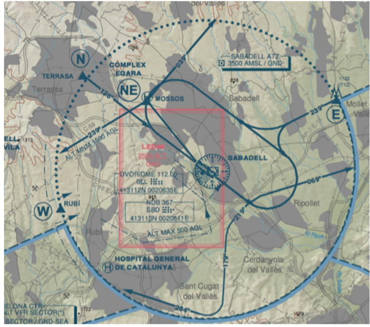
Answer
-
Turns in the airfield traffic pattern are always to the right.
-
Turns in the airfield traffic pattern are always to the left.
-
Turns in the airfield traffic pattern are to the right for runway 31 and to the left for runway 13.
-
Turns in the airfield traffic pattern are to the left for runway 31 and to the right for runway 13.
Question 54
Question
Regarding the Figure that appears at the end of this exam, what does the point Echo (E) in the chart indicate?
Answer
-
a VOR.
-
an NDB.
-
a visual reference point for the arrival procedure.
-
a visual reference point of the en-route phase.
Question 55
Question
Consider the VFR chart of the area around Limoges, provided in annex to this exam. The airspace class over the NDB LSU (south-west of Limoges airport) at 4500 ft QNH is:
Answer
-
Class C.
-
Class D.
-
Class E.
-
Class G.
Question 56
Question
An aircraft with no VHF radio equipment flying under VFR wants to take-off from St Junien (LFBJ), located at the west of Limoges, and take heading 030o approximately. Check the VFR chart provided in annex to this exam. Which of the following answers is correct?
Answer
-
This flight cannot be done without a VHF radio.
-
This flight can be done if the aircraft remains always outside the CTR of Limoges.
-
This flight can be done if the aircraft remains always outside the CTR of Limoges and always below 1000 ft above ground level
-
This flight can be done if the aircraft remains always outside the CTR of Limoges and always between 1000 ft above ground level and 4000ft above the mean sea level.
Question 57
Question
An IFR flight is crossing the Limoges airspace at 2000ft QNH following a straight line from south to north that overflies Limoges airport (dotted linne in the VFR chart provided in annex to this exam). At which point this aircraft will need a clearance to enter controlled airspace?
Answer
-
Before entering the TMA Limoges 2 (aproximatelly over St. Yrieix-la-Perche).
-
Before entering the TMA Limoges 1 (aproximatelly over Nexoh).
-
Before entering the CTR Limoges 1.
-
Before entering the CTR Limoges 2.
Question 58
Question
A VFR flight is crossing the Limoges airspace at 1500ft above ground level following a straight line from south to north that overflies Limoges airport (dotted linne in the VFR chart provided in annex to this exam). At which point this aircraft will need a clearance before entering controlled airspace?
Answer
-
Before entering the TMA Limoges 2 (aproximatelly over St. Yrieix-la-Perche).
-
Before entering the TMA Limoges 1 (aproximatelly over Nexoh).
-
Before entering the CTR Limoges 1.
-
Before entering the CTR Limoges 2.
Question 59
Question
A small aircraft with no VHF radio equipment flying in VFR wants to fly the black dotted line over the Limoges area from sourth to north at a constant altitude. Is this flight possible? If yes, at which of the following altitudes?
Answer
-
This flight cannot be done without a VHF radio.
-
500ft ASFC.
-
2000ft QNH.
-
4500ft QNH.
Question 60
Question
An helicopter is over the mountain of 1886 ft that appears in the south-est corner of the Limoges chart provided in this exam. The helicopter will be inside Restricted Area 166C if:
Answer
-
its altitude is 500 ft above ground level.
-
its altitude is 2500 ft QNH
-
its altitude is 3500 ft QNH
-
its altitude is 5000 ft QNH
Question 61
Question
An helicopter is over the mountain of 1886 ft that appears in the south-est corner of the Limoges chart provided in this exam. The helicopter will be inside Restricted Area 68B if:
Answer
-
its altitude is 500 ft above ground level.
-
its altitude is 2500 ft QNH
-
its altitude is 3500 ft QNH
-
its altitude is 5000 ft QNH
Question 62
Question
What is the airspace class at 1500 ft over the Limoges VOR?
Answer
-
Class A
-
Class D
-
Class E
-
Class G
Question 63
Question
Consider the VFR chart of the area around Perpignan, provided in annex to this exam. The lower limit of the Dangerous area D142, located over the mediterranean sea is:
Answer
-
the sea level.
-
3000 ft above the sea level.
-
3000 ft above the elevation of Perpignan airport.
-
3000 ft above the 1013.25 hPa isobar.
Question 64
Question
A search and rescue helicopter is at the St. Cyprien beach, at the south-east of Perpignan and must transport urgently a wounded person to the Hospital, which is located in Perpignan city (in between the airport and the PL NDB). This transfer flight is planned at 500 ft above the terrain and in VFR. In these conditions, which of the following statements is correct (check the VFR chart provided in annex to this exam)?
Answer
-
The pilot must always be in radio-contact with the ATC during the whole flihgt.
-
The pilot must receive a clearance to enter the CTR of Perpignan.
-
Is not necessary for the pilot to contact the ATC (albeit it is recommended).
-
VFR flights cannot enter the CTR of Perpignan. However, being a search and rescue aircraft this helicopter can proceed with the planned flight and the ATC will give it priority.
Question 65
Question
Consider the VFR chart of the area of Perpignan, provided in annex to this exam. The airspace class at 1300 ft above sea level over the beach of St. Cyprien is:
Answer
-
Class A.
-
Class D.
-
Class E.
-
Class G.
Question 66
Question
Consider the VFR chart of the area of Perpignan, provided in annex to this exam. The airspace class at 3000 ft above ground level over the town of Le Soler (West of Perpignan city and with an elevation of aproximatelly 700 ft) is:
Answer
-
Class A.
-
Class D.
-
Class E.
-
Class G.
Question 67
Question
An helicopter under Special VFR (SVFR) is executing the airfiled traffic pattern to runway 33 in Perpignan airport (see chart provided in annex to this exam). The air traffic controller is responsible to separate it from:
Answer
-
all IFR flights.
-
all VFR flights.
-
all VFR and IFR flights.
-
the controller has no separation responsibility with SVFR flights in this CTR.
Question 68
Question
A VFR flight is flying inside Perpignan TMA 7 (see the northwest corner of the chart provided in annex to this exam). The air traffic controller is responsible to separate it from:
Answer
-
all IFR flights.
-
all VFR flights.
-
all VFR and IFR flights.
-
the controller has no separation responsibility with VFR flights in this part of the TMA.
Question 69
Question
What is the main effect of the flaps/slats configuration in an aircraft performance model?
Answer
-
they significantly change the wing surface.
-
they change the engine thrust parameters (engine efficiency).
-
they change the CD0 and CD2 parameters of the drag coefficient.
-
they do not have a significant impact in an aircraft performance model.
Question 70
Question
In the San Francisco airport (SFO), two parallel approaches are executed if visibility meteorological conditions (VMC) are met. Otherwise, only one instrumental approach is executed in one of the runways. This is a illustrative example of a trade-off, or interdependency, between:
Answer
-
flight efficiency and environmental impact.
-
flight efficiency and safety.
-
capacity and safety.
-
capacity and flight efficiency.
Question 71
Question
Minimum aircraft separation standards in oceanic areas are much larger than separation in continental areas with radar coverage. This is a illustrative example of a trade-off, or interdependency, between:
Answer
-
flight efficiency and environmental impact.
-
flight efficiency and safety.
-
capacity and safety.
-
capacity and flight efficiency.
Question 72
Question
Continuous descent operations are not possible in very congested airports. This is a illustrative example of a trade-off, or interdependency, between:
Answer
-
flight efficiency and environmental impact.
-
flight efficiency and safety.
-
capacity and safety.
-
capacity and flight efficiency.
Question 73
Question
Noise optimal departures (i.e. minimising noise exposure over the population) typically require more fuel since the aircraft might be required to climb at not optimal speeds and/or fly longer distances to avoid certain populated areas. This is a illustrative example of a trade-off, or interdependency, between:
Answer
-
flight efficiency and environmental impact.
-
flight efficiency and safety.
-
capacity and safety.
-
capacity and flight efficiency.
Question 74
Question
It has been reported in many studies that the United States of America (USA) ATM system, if compared with the European system, handles almost the double of traffic but with much less technical staff and air traffic controllers involved. Which of the following potential reasons is correct?
Answer
-
The European airspace is much more complex to manage in terms of aircraft density and network topology.
-
The European airspace is managed by many air navigation service providers, using different systems and procedures; and it is very constrained with several military zones.
-
The USA communication and navigation systems are much more advanced if compared with the European technology, leading to significant capacity increases.
-
The USA surveillance systems are more precise, allowing for lower separation margins between aircraft.
Question 75
Question
Which of the following pieces of aeronautical information could potentially appear in a NOTAM message?
Answer
-
”... runway 27L closed for maintenance ...”
-
”... traffic at 11 o’clock at 2NM, 200ft below, Cessna 172 crossing from left to right... ”
-
”... wind is 280 at 20 kt, visibility is 5km, ... ”
-
All answers are correct.
Question 76
Question
Which of the following pieces of aeronautical information could potentially appear in a flight information service (FIS) message?
Answer
-
”... runway 27L closed for maintenance ...”
-
”... traffic at 11 o’clock at 2NM, 200ft below, Cessna 172 crossing from left to right... ”
-
”... wind is 280 at 20 kt, visibility is 5km, ... ”
-
All answers are correct.
Question 77
Question
Which of the following pieces of aeronautical information could potentially appear in an ATIS message?
Answer
-
”... traffic at 11 o’clock at 2NM, 200ft below, Cessna 172 crossing from left to right... ”
-
”... sectorisation in Barcelona TMA from 10h to 12h is 11 Victor... ”
-
”... transition level is seven zero, ...”
-
All answers are correct.
Question 78
Question
What is an aeronautical information circular (CIRC)?
Answer
-
It is a notice or advisory that contains useful information for pilots or potential hazards along a flight route or at a location, such an airport, in the short term.
-
It is information for aircraft operators that typically contain administrative, explicative or advice that in the long term can affect their operations.
-
It is a document where two air traffic control centres agree in how traffic is transferred (specifying, for instance exit flight levels).
-
It is the chapter of the national AIP where the rules of the air that apply to that specific country are described.
Question 79
Question
Which of the following indicators could be representative to measure flight efficiency in a terminal manoeuvring area?
Answer
-
The average number of people exposed above a certain noise level.
-
The average length of trajectory level-offs in departures and/or arrivals.
-
The number of aircraft executing approaches for a given period of time.
-
The number of air traffic controllers divided by the amount of controlled time, and for a given period of time.
Question 80
Question
Which of the following indicators could be representative to measure flight efficiency in the en-route phase?
Answer
-
The difference, in terms of additional flight distance, between the actual trajectory and the optimal trajectory.
-
The average separation between aircraft for a given period of time.
-
The number separation violations between aircraft reported in a given period of time.
-
The average number of aircraft inside an air traffic control sector for a given period of time.
Question 81
Question
Airspace Management strongly depends on:
Answer
-
the Aeronautical Information Services (AIS) available.
-
the actual weather conditions.
-
the Communications, Navigation and Surveillance (CNS) infrastructure available.
-
all the answers are correct.
Want to create your own Quizzes for free with GoConqr? Learn more.