2715599
Description
Quiz by Pauline Leota, updated more than 1 year ago
|
|
Created by Pauline Leota
over 10 years ago
|
|
Question 1
Question
What are key differences between an Urban Road(UR) and a Rural Road (RR)?
Answer
-
a UR has a kerb and channel
-
An UR is black with grey stones and the RR is grey with black stones
-
An UR has a footpath and a RR has none
-
A RR has a subsoil drain
-
The RR has been strengthen to take live stock walking on it
-
The RR has a feathered edge
Question 2
Question
What are the similarities between a Urban Road and a Rural Road?
Answer
-
Camber-usually 3%. under channel drains, waterproofing surface, road boundaries, pavement layers
-
Camber 6%, footpaths, berms, kerbs and pavement layers
-
There are no similarities between a Urban road and a rural road
Question 3
Question
Other differences between urban roads and rural roads are: cost, environmental issues, design, maintenance, surface water management, resource consent process
Answer
- True
- False
Question 4
Question
What are the road user expectations when it comes to the design of a road?
Answer
-
Direct route between two points
-
Useable in all weather conditions
-
Provides a smooth comfortable surface
-
allows traffic to ravel safely at a reasonable uniform cruising speed
-
Is pleasing to the eye and has lots of nice scenery
-
has petrol stations every 500m
Question 5
Question
What are the consultation requirements?
Answer
-
Communicating with the community even though the construction is a Permitted activity
-
Considering Risks
-
Include time, cost implications, resources and raising community expectations
-
Take into consideration the principles of the Treaty of waitangi
-
all of the above
Question 6
Question
What is the best practice for consultation
Answer
-
Hold initial discussions with community leaders, key agencies and local government politicians to gauge the level of understanding and support for the proposed project
-
Clearly state the issues that are being consulted on
-
Disseminate information and educational material to the community on the rationale for the project
-
Included community leaders etc in the site selections process and scoping of the community interest
-
Seek legal advice - compliance with the ACT is crucial
-
all above
Question 7
Question
There are 18 Factors to consider for a new alignment. Learn 5 of them for the test
Answer
-
1. keep grades and curvature to the minimum necessary to satisfy the service requirements of the highway 2. Always provide adequate sight distance and avoid sudden changes in sight distance especially near intersections 3. Avoid having a sharp horizontal curve on or adjacent to a pronounced vertical curve 4. Locate the highway wherever possible along property boundaries not through the middle of blocks of land particularly farm land
-
5. Where it is practical maximize use of existing highway alignment to reduce land purchase costs 6. Avoid areas or objects of historical, recreational or cultural significance 7. Never have two roads intersecting near a bend or at the top or bottom of a hill 8. Avoid at grade intersections with railway lines. If possible cross the railway where it enters a cutting
-
9. Keep road and stream crossing to a sensible minimum and if possible have crossing at right angles 10. Avoid horizontal curves in bridges, tunnels or culvert structures 11. Avoid where possible unstable ground prone to erosion or land slips 12. Avoid low lying land prone to flooding 13. Avoid if possible locations with rock close to the surface
-
14. In hilly terrain the highway should cross ridges at their lowest point. Avoid creating severe breaks n the natural skyline 15. Minimize destruction of natural forest areas where some felling is necessary locate the road on a curve to preserve an unbroken background and minimize visual impact. 16. Avoid placing a road at right angles to natural drainage pattern 17. Balance volumes of cut and fill within a section of road to avoid need to purchase or tip large quantities of fill 18. To relieve the monotony of driving on a long straight road it is an advantage to site it so as to give a view of some prominent feature ahead.
-
All of the above
Question 8
Question
The highway location process is an iterative (repetitive) one where a design is gradually refined until the most suitable location is decided upon.
Answer
- True
- False
Question 9
Question
The highway location process is:
Answer
-
1. choose site 2. buy the land 3. decide where to place the road 4. Draw it on a map 5. Take it to council for approval
-
1. Fix end points of alignment 2. Examine the region containing both end pints and all feasible routes between them 3. Decide on a number of broad bands in which to concentrate further investigations (8 to 16km wide for major motorway) 4. Narrow bands down to corridors 3-8kms wide 5. Compare three corridors in detail and select the best 6. Generate a route within the selected corridor 1-1.5km wide 7. Search route area and locate one or more possible alignments up to 30 m wide 8. Select final alignment
Question 10
Question
What are the elements of a Roadway
Answer
-
Lane
-
Median
-
Traffic Islands
-
Right and left turn lanes
-
Median openings
-
Shoulder
-
Carriageway
Question 11
Question
Design Parameters: What do we need to consider in designing a road?
Answer
-
Road Classification, Traffic volumes and composition,
-
Design speed, design vehicle, Environment,
-
Access, Drainage, Utility services
Question 12
Question
A road design needs to consider horizontal, vertical alignment and the cross section
Answer
- True
- False
Question 13
Question
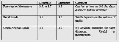
The desirable standard lane width is 3.5 and up to 3.7m for freeways or motorways
Answer
- True
- False
Question 14
Question
The minimum lane width is 3.5 for standard roads and 3.0 for Motorways
Answer
- True
- False
Question 15
Question
What is the camber on a cross section of a chip Seal road
Answer
-
6%
-
2%
-
3%
Question 16
Question
Horizontal curves should be of the same type, have the same design speed or gradually reduce (<10%/cure)over the length of the road
Answer
- True
- False
Question 17
Question
Compounded curves are to be avoided What are compound curves
Answer
-
different radii turning in the same direction
-
two curves in same direction with little or no straight in between
-
to curves turning in opposite directions with little or no straight in between
Question 18
Question
Broken back curves are to be avoided what are broken back curves?
Answer
-
different radii turning in the same direction
-
two curves turning in the same direction with little or no straight in between
-
two curves turning in opposite directions with little or no straight in between
Question 19
Question
Reverse curves are to be avoided when designing a road, what is a reverse curve?
Answer
-
different radii turning in same direction
-
two curves turning in same direction with little or no straight in between
-
two curves turning in opposite directions with little or no straight in between
Question 20
Answer
-
the amount by which the outer edge of a curve on a road or railway is banked above the inner edge
-
the camber of 3%
Question 21
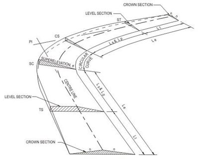
Question
A transition curve smooths travel around a curve of speeds less than 60km/h, radius of curve greater than 500m and Shift greater than 0.3m
Answer
- True
- False
Question 22
Question
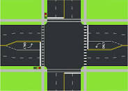
What is an intersection in the road
Answer
-
An intersection is the junction at grade (that is to say, on the same level) of two or more roads either meeting or crossing.
-
An intersection may be three-way (a T junction or Y junction – the latter also known as a fork), four-way (a crossroads), or have five or more arms.
Question 23
Answer
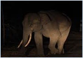
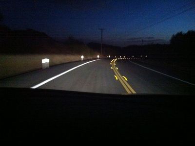
-
The distance it takes in the dark to see an elephant
-
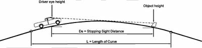
The distance at which a driver will be able to perceive an object of a specific height on the road ahead and safely stop their vehicle before it reaches that object
Question 24
Question
A sag curve is determined by the headlight sight distance not just a sag at the bottom of the road
Answer
- True
- False
Question 25
Question
What are the grades for road designs?
Answer
-
not steeper than 10% average or 12.5% maximum
-
lot access can be up to 1V:5H
-
Minimum grades for roads with kerb and channel = 0.3%, Unkerbed roads =0.5% Unkerbed roads with side drainage = 0%
Question 26
Question
a vertical curve is the curve on the road design running the length of the road vertical curves can be on the top of a crest or the sag at the bottom.
Answer
- True
- False
Question 27
Question
The Design process has 7 Steps Learn all 7 steps
Answer
-
1. Identify Controls
-
2. Prepare Horizontal Alignment
-
3. Select grading points
-
4. Prepare longitudinal section Show natural GL and Grading Points Include Intersections,structures, services, and crossings
-
5. Prepare Trial grade-line Consider controls try to coordinate horizontal and vertical alignments
-
6. Calculate earth works quantities
-
7. Adjust vertical alignment so that : Controls are met Earthworks are minimized
Question 28
Question
Controls are the factors that influence the design
Answer
- True
- False
Question 29
Question
What are factors that influence design levels?
Answer
-
operating speed, required sight distances, overtaking requirements, drainage systems
-
Earthworks, topography, flood levels, water table levels
-
Geotechnical conditions, existing intersections, property entrances
-
overpasses and underpasses, pedestrian access, services
-
All of the above
Want to create your own Quizzes for free with GoConqr? Learn more.