
Karteikarten
Natural Hazards
Karten in diesem Stapel (65)
- 1What are the primary effects of Earthquakes?buildings collapse
roads crack
bridges collapse
glass shatters
gas pipes break
electricity pylons fall
water pipes break - 2What are the secondary effects of Earthquakes?fires
explosions
floods / land slides
homelessness + business destruction
tsunamis
diseases
unemployment
insurance claims - 3What are the primary effects of Volcanic eruptions?Buildings destroyed by fires
explosions
weight of ash; crops / livestock destroyed - 4What are the secondary effects of volcanic eruptions?Mudflows
change in landscape / climate
food / water supply disrupted
homelessness
business forced to close
cost of insurance claims
unemployment - 5What is the Richter scale?a measure of earthquake strength
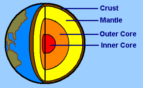
- 6What are the different layers of the earth, starting from the middle working outwards...
- 7What are tectonic plates?large segments of the earths crust
- 8What is the liquid rock below the earths surface called?magma
- 9Which type of crust is more dense? and therefore sinks?oceanic crust
- 10Which type of crust is less dense?continental crust
- 11What are the differences between continental and oceanic crust?Continental = land crust / thicker / less dense
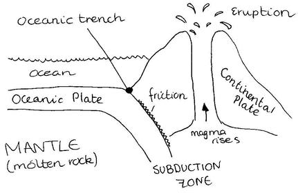
Oceanic = water crust / thinner / denser - 12What happens at a destructive plate margin?
- 13What happens at a conservative plate boundary?
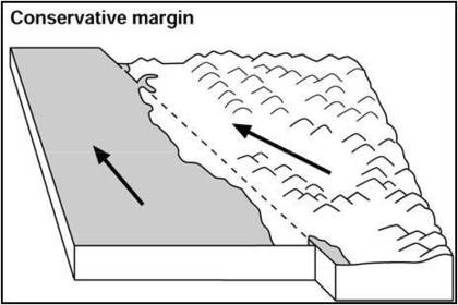
- 14What happens a lot at conservative plate boundary's?snag
(stress builds as the plates catch on each other until it is released quickly usually causing an earthquake) - 15What happens at a constructive plate boundary?
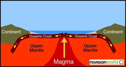
- 16What are you likely to see at constructive plate boundary's?Volcanic islands
- 17What are the reasons people live near tectonically active areas?Geothermal energy
Tourism
Agriculture
Geographical inertia
Minerals
Ignorance
Scenery - 18What is retrofitting?the addition of new technology to older buildings
- 19What is the epicentre of an earthquake?the point on the Earth's surface directly above the focus of an earthquake
- 20How can you earthquake proof a building?
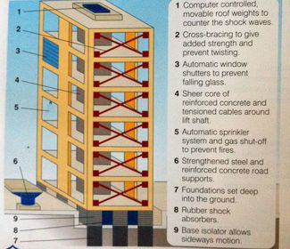
- 21How many people in the world now live in Bamboo houses?1 million+
- 22Describe an earthquake case study in a small amount of detail...Costa Rica
January 2009
6.1
all bamboo house in epicenter survived
34 dead - 23Where are earthquake resistant houses being constructed from local and recycled materials?Gujart, India
- 24Describe some of the features in earthquake-resistant housing in Gujarat in India...
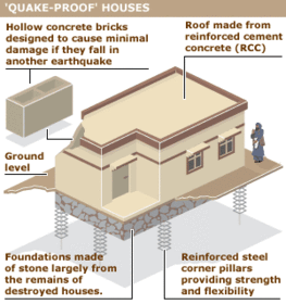
- 25Why are bamboo houses effective against earthquakes?Bamboo is very strong, yet bends easily and has been proven to withstand much earthquake shaking
- 26What is earthquake preparedness?People being aware of the actions to take before, during and after an earthquake to reduce casualties
- 27How can the government make sure people are earthquake 'prepared'?regular drills
teach in schools
posters
lectures - 28What is an example of the government making sure the people are prepared for earthquake?Japan
'Disaster Prevention Day'
1st September - day of 1923 Great Kanto in Tokyo
people are reminded of what to do in the event of an earthquake - 29What are things before an earthquake you can do to prepare?create a disaster plan
prepare your home - secure heavy or damageable furniture - 30What are building codes?regulations which state how a building should be constructed in order for it to be safe
- 31What do scientists look for an increase in if a volcano might erupt?Seismic activity
- 32If it clear that a volcanic eruption is likely, then a course of action has to be decided upon. Several options could be considered including:restricting access to the area
evacuating the area
reducing the effects of the eruption - 33What is laser ranging?using laser beams and mirrors to detect minute changes in the shape of the land.
- 34What is laser ranging used for?to detect any bulges in the volcano
- 35What is evacuation?movement of people away from a place of danger to a place of safety
- 36What is an example of an evacuation plan for an earthquake?May 2006
Mount Merapi overlooking Yogyakarta
17,000 people
people into danger were put into emergency shelters
orange code - then to red - 37How can people prepare for a volcanic eruption?Improved building design
sealing doors and windows
increased awareness
volcanic hazards
emergency kit - 38What are storm surges?abnormal rise of the sea along a shore as the result of the storm, sometimes called a tidal surge
- 39What are the physical and environmental effects of tropical storms?Structural damage
sensitive environments destroyed
loss of animal habitats
fresh water fish die in storm
fishing and other boats damaged - 40Social effects of tropical storms?trauma / stress
water borne diseases
communities broken up
food and water shortages
job losses
looting - 41Economic effects of tropical storm?Repair and insurance claims
loss of income
crops destroyed
exports lost
oil prices may increase - 42Example of Hurricane?Hurricane katrina
Category 5
2005 August
1800 dead
$108 billion
storm surge - 43How hot does the sea have to be for tropical storms?27 degrees +
- 44How far from the equator?between 10 and 30 degrees north and south of the equator
- 45What are tropical storm strengths measured in?The Saffir Simpson scale
(1 being weakest - 5 being strongest) - 46what are the stages in the formation of a tropical storms?1.thunderstorms drift over warm seas
2. warm air from sea surface and the thunderstorms combine and warm air starts to rise
3. warm
air rises, starts to spin in spiral, cools and condenses to make clouds
4.air starts to rise faster and cooler air is sucked downwards
5.moves over ocean - 47what direction do hurricanes travel in?westwards
- 48what 3 steps to follow if a tropical storm is coming?forecast -> prepare -> act
- 49what is a mandatory evacuation?an evacuation that is commanded by the authorities
- 50What company forecasts hurricanes?National Hurricane Centre (Atlantic)
Joint Typhoon Warning Centre (Pacific) - 51How to prepare for a hurricane?-education
-emergency kit
-windproof tiles
-water-resistant windows
-strengthened buildings - 52Example of an NGO (non government organization) helping people prepare for a hurricane?Bangladesh
cyclone shelters
homes on stilts
educating women - 53natural cycle definitionseries of events in nature that are repeated over and over again
- 54el nino definitiona warning of the ocean surface off the western coast of south america
- 55Why are hurricanes likely to increase?Global warming --> sea temp rises
- 56Primary effects of wildfires?loss of life / injury
destruction of property
burning of crops
water and air pollution
health problems - 57Secondary effects of earthquakes?loss of jobs and income
Homelessness
rebuilding is costly
insurance costs
tourism loss
economy fail :( - 58wildfire example?Black Saturday
February 2009
Across state of Victoria
173 died
400 individual fires - 592 causes of wildfires?natural
human - 60natural causes of wildfires?Lightning
spontaneous heating
volcanic eruptions - 61human causes of wildfires?accidents
broken bottles
slash and burn
arson
train wheels / machinery / barbeques - 62How do people respond to a wildfire?airplanes and helicopters air drop
fire breaks
fire fighters use foam and water
backfire
evacuation - 63How do people prevent and prepare for a wildfire?Volunteers remove debri+dead leaves
Smokey Bear (used for over 60 years in USA)
making homes fireproof
make evacuation plans
Geographical Information System has wildfire risk maps - 64Why will wildfires increase in the future?global warming
wild land-urban interface
natural cycle - 65What 3 things have been increasing in terms of wildfires?higher wildfire intensity
higher cost of damage
increased length of wildfire season
Informationen
- Beschreibung
- GCSE Geography (Natural Hazards) Karteikarten am Natural Hazards , erstellt von becky_e am 14/05/2014.
- Erstellt von
- becky_e
- Aufrufe
- 336
- Tags
- Bewertung