
Mindmap
Tectonic Hazards
Inhalt der Mindmap
Tectonic Hazards
Plate Boundaries
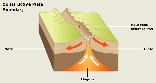
- Constructive Plate Boundary
- Two plates move away from each other
- Example
- North American and Eurasian
- Mid-Atlantic Ridge
- North American and Eurasian
- Causes
- Volcanoes are formed as magma rises to fill the gap
- New crust is formed
- Volcanoes are formed as magma rises to fill the gap
- Example
- Two plates move away from each other
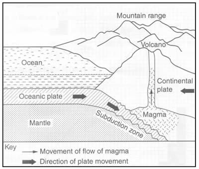
- Destructive Plate Boundary
- Oceanic plate forced under Continental plate (subduction as Oceanic plate is lighter than the Continental Plate) . Edge of continental plate folded upwards to form a mountain range.
- Example
- Pacific and Eurasian
- Nascar Plate forced under the South American Plate
- Pacific and Eurasian
- Causes
- Earthquakes as friction causes the melting of the Oceanic plate
- Volcanic eruptions as magma rises up through the cracks to the surface.
- Example
- Oceanic plate forced under Continental plate (subduction as Oceanic plate is lighter than the Continental Plate) . Edge of continental plate folded upwards to form a mountain range.
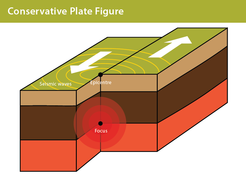
- Conservative Plate Boundary
- Two plates slide past each other. They don't slip, they get stuck and pressure builds until the plates jump forward sending out shockwaves.
- Example
- North American and Pacific
- San Andreas Fault
- North American and Pacific
- Causes
- The shockwaves that are sent out when the plates jolt forward cause earthquakes
- Example
- Two plates slide past each other. They don't slip, they get stuck and pressure builds until the plates jump forward sending out shockwaves.
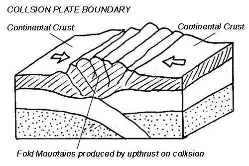
- Collision Zones
- Two continental plates collide with each other. Neither plate is forced under there other so Fold Mountains are formed.
- Example
- Indo-Australian and Eurasian
- Indian tectonic plate pushing up and against the Asian plate
- Mount Everest
- Indian tectonic plate pushing up and against the Asian plate
- Indo-Australian and Eurasian
- Causes
- Mountains such as Mount Everest
- Example
- Two continental plates collide with each other. Neither plate is forced under there other so Fold Mountains are formed.
- Constructive Plate Boundary
Volcanos
- Hotspot
- Shield
- Shape: Shield Shape but much broader than constructive
- Areas where a plate is particularly thing, magma is able to escape to the surface.
- Causes
- Creates new land
- Eruption
- Almost continuous
- Gentle oozing
- Produces: Lava
- Example
- Mauna Loa, Hawaii
- Causes
- Shield
- Constructive
- Shield
- Shape: Shield Shape
- Two plates moving apart and magma can reach the surface through the crack.
- Causes
- Create submarine mountain ranges - ocean ridges.
- Mid-Atlantic ridge
- Create submarine mountain ranges - ocean ridges.
- Eruption
- Gentle (Effusive)
- Produces: Ash and Lava
- Runny Lava with low silica content
- Therefor goes far
- Large ash clouds
- Runny Lava with low silica content
- Frequent
- Doesn't build up pressure
- Example
- Surtsey - Iceland
- Causes
- Shield
- Destructive
- Composite
- Shape: Steep Sides and Cone Shaped
- High
- Shape: Steep Sides and Cone Shaped
- One plate goes beneath an other. Friction causes that plate to melt. The magma forces its way to the surface to form a volcano.
- Eruption
- Produces: Ash, Lava Pyroclastic Flows
- Lava has a high silica content and viscous
- Less runny
- Lava has a high silica content and viscous
- Not frequent
- Has time to build up pressure causing more violent eruptions
- Massive craters
- Secondary cone to release pressure to ensure that the whole volcano doesn't blow
- Has time to build up pressure causing more violent eruptions
- Produces: Ash, Lava Pyroclastic Flows
- Composed of different layers: ash and lava
- Example
- Mount St Helens
- Eruption
- Composite
- Why people choose to live near volcanos
- Cost Vs Benefit
- Fertile Land - Over time nutrients from the volcano make land more fertile
- Mining - Resources
- Geothermal Energy
- Tourism
- Family in the area/They were born there
- Job there
- Lack of Alternatives
- "It will never happen to them"
- Prediction
- Historical Records
- Gap between eruptions and how consistent it is.
- Geostationary Satellites
- Take infa-red images of the volcano to see where magma is and if it is rising.
- Seismometers
- Detect small tremors in the earth and anything irregular could mean lava is rising and pressure building.
- Hydrology
- Amount of water content in the ground. If it's high it could mean magma is rising as it is heating up the ground water, making it rise so an eruption is likely.
- Gas
- Monitoring the gases that come out of the volcano, such as Sulphur. If a rise in the reading then this could mean an eruption.
- Geophysical Measurements
- Checks the acidity of the soil. Gases from the volcano make soil acid so high acidity - likely eruption.
- Ground Deformation
- Sensors track how much over time the ground changes. If the ground moves unexpectedly then magma chamber could be getting bigger as well as pressure building.
- Historical Records
- Management
- Channel it: Digging trenches
- Insurance
- Education. What to do
- Warnings
- Land use planning
- Giving aid
- Hotspot
Bilder und Dateien der Mindmap
Informationen
- Beschreibung
- A Mindmap of Tectonic Hazards
- Erstellt von
- David Goldng
- Aufrufe
- 206
- Tags
- Bewertung