2109154

| Question | Answer |
| Define: HYDROLOGICAL or WATER CYCLE | the constant movement of water around the Earth. Water travels from the sea to the atmosphere to the land and back to the sea in a giant closed system (the amount of water remains exactly the same). Water is stored in some places within the cycle and transferred between stores by flows. |
| Define: CLOSED SYSTEM | there is a fixed amount of water in the system because water neither enters nor leaves the Earth and its atmosphere. |
| Define: OPEN SYSTEM | an open system has INPUTS where water enters the system through precipitation (rain and snow) and OUTPUTS where water is lost to the system either by rivers carrying it to the sea or through evapotranspiration |
| Define: STORES | Places where water is held, such as in pools and lakes on the surface or in soil and rocks underground. |
| Define: TRANSFERS (flows) | the processes by which water flows, or moves, through the system and between stores in the hydrological cycle. Examples include infiltration, surface runoff, throughflow. |
| Water stored in the ATMOSPHERE... | here the water exists either as water vapour or as minute droplets in clouds |
| Water stored in the LAND... | here water is stored on the surface in rivers, lakes and reservoirs. Water is also taken in by plants and temporarily stored in vegetation. It is also stored below ground in the soil or bedrock (groundwater store). |
| Water stored in the SEA... | it is estimated that over 95% of the Earth's water is stored in the sea. This is overwhelmingly held in liquid form (water), but also in the form of ice, for example the icebergs in high-latitude seas. |
| Define: EVAPORATION | the hydrological cycle starts with evaporation by the heat of the Sun. Water is converted from a liquid into a gas (water vapour). This takes place from the surface of water surfaces (sea, pond, lakes). Evaporation is particularly important in the transfer of water from the sea store into the atmosphere. |
| Define: TRANSPIRATION | plants take up liquid water from the soil and "breath" it into the atmosphere as water vapour |
| Define: INPUTS | where water enters the system through precipitation (rain and snow) |
| Define: OUTPUTS | where water is lost to the system either by rivers carrying it to the sea or through evapotranspiration |
| Define: EVAPOTRANSPIRATION | the loss of moisture directly from rivers or lakes (evaporation) or from vegetation (transpiration) |
| Define: INFILTRATION | the downward movement of water through tiny pores in the soil |
| Define: THROUGHFLOW | the movement of water sideways. It is likely to form, eventually, a spring on a valley side |
| Define: PERCOLATION | the movement of water downwards that forms groundwater |
| Define: GROUNDWATER | water stored at a depth in rocks |
| Define: SURFACE RUNOFF / OVERLAND FLOW | water that flows across the surface of the ground (not in a stream or river). This happens when the surface doesn't allow water to penetrate, such as when the ground is saturated or when the rock is impermeable. Surface runoff is the fastest process of water movement. |
| Define: WATER TABLE | the level of saturation in rock/soil, i.e. when all the pores have been filled with water |
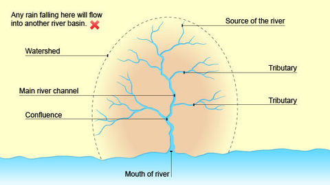
| Define: DRAINAGE BASIN (catchment area) | an area of land drained by a main river and its tributaries |
| Define: WATERSHED | a boundary, often marked by a ridge of higher land, that separates one drainage basin from neighbouring ones |
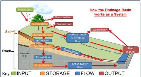
| A drainage basin... drainage basin cycle | has a movement of water within it that is rather like a small-scale water cycle the drainage basin cycle involves stores and flows |
| Drainage basin, open system... | the important difference between a drainage basin and the hydrological cycle is that the former is an open system it has external inputs and outputs; the amount of water in the system in the basin varies over time |
| Formula: DRAINAGE DENSITY | the total length of all streams in the drainage basin ------------------------- the total area of the drainage basin |
| Where is the Earth's water? | ≈ 97% Seas and Oceans ≈ 2% Ice and Snow (in arctic and alpine areas) ≈ 1% Fresh Water on Land or Water Vapour in the Atmosphere |
| Example of Inputs | precipitation |
| Examples of Outputs | evapotranspiration (evaporation, transpiration from vegetation); river carrying water to lakes or the sea |
| Examples of Transfers (flows) | stemflow; infiltration; percolation; surface runoff (overland flow); throughflow; groundwater flow |
| Examples of Stores | interception by vegetation; surface storage; soil moisture storage; groundwater storage |
| Define: CATCHMENT AREA | the area within the drainage basin |
| Define: SOURCE | the beginning or start of a river; often at a higher altitude like the top of a mountain |
| Define: MOUTH | the point where the river comes to the end, usually when entering a sea or lake |
| Define: CONFLUENCE | the location where tributaries enter the main river channel; the point at which two rivers or streams join |
| Define: TRIBUTARY | a stream or smaller river which joins a larger stream or river |
| Define: ESTUARY | part of the mouth or or lower course of a river in which the river's current meets the sea's tide; the river's velocity decreases rapidly, depositing a majority, if not all, of its load |
| Define: DISCHARGE | the volume of water which flows through a river at a given time; it is measured in cumecs (cubic metres per second) |
| Define: the DRAINAGE NETWORK | the system of surface and underground channels that collect and transport the precipitation falling on the drainage basin |
| Factors affecting run off: (EIG p5 fig 1.5) | 1) rapid run off - steep slopes; impermeable rock (grit) 2) little run off - permeable rock; rivers have disappeared underground (clay) 3) woodland - slows rate of run off (clay) 4) urban area - speeds up rate of runoff |
| Runoff in woodland area | woodland can hold water and slow overland flow. However, once it is cleared for cultivation, run off will speed up |
| Runoff in urban area | rainwater hits solid surfaces such as roofs, pavements and roads. It is then quickly channelled into drains which speed its delivery into a stream or river |
| a typical drainage basin system (WW p279 fig 17.4) | |
| Define: VELOCITY | the speed of the river; it is measured in m/s |
| Define: VOLUME | the amount of water in the river system; it is the cross sectional area of the river's channel measured in m² |
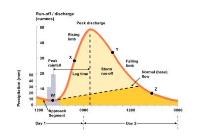
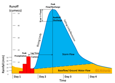
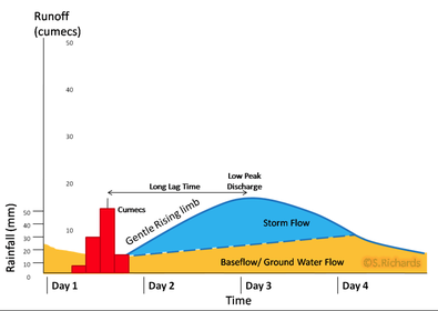
| Define: HYDROGRAPH | a graph showing the discharge of a river at a given point over a period of time |
| A flood or storm hydrograph shows... | a flood or storm hydrograph shows how a river responds to one particular storm |
| Define: LAG TIME | the gap between the time of peak (max) rainfall and peak discharge (highest river level) |
| Lag time and chances of flooding | a short lag time will cause the river discharge to rise steeply. The steeper the rise in discharge, the greater the chances of flooding. on the contrary, a lengthy lag time means lower discharge and less chances of flooding |
| labelled diagram of a flood/storm hydrograph (WW p280 fig 17.5) | |
| basic features of the drainage basin (EIG p4 fig 1.4) | |
| Factors affecting the shape of a steep flood hydrograph (WW p281 fig 17.7) | RELIEF - faster runoff on steep slopes ROCK TYPE - surface runoff on impermeable rock (e.g. grit) NATURAL VEGETATION - thin grass and moorland; less interception SOIL - very thin soil; less infiltration |
| Factors affecting the shape of a steep flood hydrograph (WW p281 fig 17.7) | LAND USE - urbanisation; increased tarmac (impermeable layer) and drains (increased runoff). Arable land exposes more soil USE OF RIVER - limited use DRAINAGE DENSITY - higher density means more streams to collect water quickly |
| Factors affecting the gentle shape of a flood hydrograph (WW p281 fig 17.7) | RELIEF - slower runoff on more gentle slopes ROCK TYPE - throughflow and groundwater flow as rainfall infiltrates into permeable (porous) rock NATURAL VEGETATION - forest; most interception. Roots delay throughflow and absorb moisture. Evapotranspiration reduces chances of water reaching river |
| Factors affecting the gentle shape of a flood hydrograph (WW p281 fig 17.7) | SOIL - deeper soil; more infiltration LAND USE - rural area with little tarmac, concrete or drains. Tree crops and arable farming increase interception USE OF RIVER - water extracted for industry, domestic use and irrigation. Dam built to store water DRAINAGE DENSITY - lower density; fewer streams to collect water |
| Causes of river flooding from weather | extreme weather conditions - a torrential thunderstorm, several days of continuous rainfall, or heavy snowfall melting while it rains increase the discharge of a river |
| Factors contributing to flooding | 1) although high summer temperatures increase evapotranspiration and reduce the amount of water available to reach a river, they can make the ground hard, reducing infiltration when it does rain 2) freezing conditions in winter can make the ground impermeable |
| Define: RIVER REGIME | the difference in the discharge of the river throughout the year in most rivers, the regime closely reflects local climatic conditions, particularly the rainfall regime |
| Define: BASE FLOW | the regular discharge of the river |
| Define: STORM FLOW | the additional discharge of the river directly related to the passing of the rainstorm |
| Factors affecting the critical time lag of a storm: | the amount and the intensity of the rain - heavy rain will not sink into the ground; instead it will become overland flow or run off and quickly reach the river |
| Factors affecting the critical time lag of a storm: | temperatures are significant because they affect the form of precipitation. For example, if temperatures are below freezing, precipitation will be in the form of snow. This can take weeks to melt. If the ground remains frozen, melting snow on the surface can reach the river quickly |
| Factors affecting the critical time lag of a storm: | land use - trees and plants will intercept and delay the rain reaching the ground. Bare soil and rock will speed up runoff and reduce the time lag. So too will urban areas covered by tarmac and concrete |
| Factors affecting the critical time lag of a storm: | steep slopes will cause rapid surface runoff, so water will reach the river more quickly. Flat and gently sloping land may lead to water sinking into the soil. This will delay it reaching the river |
| Factors affecting the critical time lag of a storm: | rock type - impermeable rocks will not allow rainwater to sink into it, so will speed up runoff. Permeable rock will allow infiltration and percolation of water into the bedrock. This in turn will slow the delivery of the water to the river |
| Factors affecting the critical time lag of a storm: | dams and reservoirs regulate and even out discharges. They hold back discharge and so reduce the risk of flooding downstream |
| Define: WETTED PERIMETER | where the water comes into contact with the river’s banks and bed |
| Friction at the wetted perimeter in an upland stream | Despite waterfalls where the velocity is locally high, the large number of angular boulders and uneven river banks give a large wetted perimeter which increases friction and reduces velocity |
| Friction at the wetted perimeter in a lowland river | Here there is relatively smaller wetted perimeter in comparison with the volume. Due to this, and the smoother banks and bedload, friction is reduced, allowing velocity to increase |
| River and shaping landforms | Rivers play a major part in shaping landforms. They do this work by means of three processes – erosion, transport and deposition. They act in a sort of partnership with two other processes – weathering and mass movement |
| Define: LOAD | material that is transported by a river |
| Picking up load in a river | Following a period of heavy rain, or after the confluence with a major tributary, the volume of the river will increase. Friction is reduced as less water comes in contact with the wetted perimeter; the river will increase its velocity. The surplus energy, resulting from the decrease in friction, can now be used to pick up and transport material. |
| Processes of Transportation: | traction saltation suspension solution |
| Define: TRACTION | rolling stones/boulders along the bed (this needs the most energy) |
| Define: SALTATION | sand-sized particles bound along the bed in a “leap-frog” movement |
| Define: SUSPENSION | silt and clay-sized particles are carried with the water flow |
| Define: SOLUTION | some minerals dissolve in the water (this needs the least energy) |
Want to create your own Flashcards for free with GoConqr? Learn more.