
Flowchart
Amazonía u Oriente
Flowchart content
La Amazonía u Oriente
Provincias
Sucumbíos
Orellana
Napo
Pastaza
Morona Santiago
Zamora
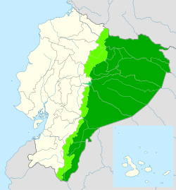
Es una región natural del país sudamericano conformada por un área aproximada de 120.000 km² de la Amazonia.
Representa el 43% del territorio ecuatoriano. Sus límites están marcados por la Cordillera de los Andes en la parte occidental de esta región, mientras que Perú y Colombia
Information
- Description
- User has deleted their subject information Flowchart on Amazonía u Oriente, created by Deleted user on 07/01/2021.
- Created by
- Deleted user · Jan 2021
- Updated
- Jan 7, 2021
- Views
- 27
- Tags
- History
-
- Created by MARIA VICTORIA ENCALADA NUÑEZ · Jan 7, 2021
- Copied by MARIA VICTORIA ENCALADA NUÑEZ · Jan 7, 2021
- Rating