
Notes
Glacial Landforms: A-Level Geography
Content of the notes (9)
Page 1
Glacial Landforms
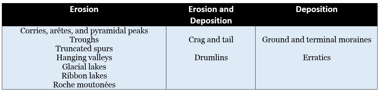
Glacial landforms can be split into several categories - those formed by erosion, deposition or both.
Glacial landforms can also be organised by size.
Macro-scale landforms include: Knock and lochan landscapes, cirques, arêtes, pyramidal peaks, glacial troughs, moraines etc.
Meso-scale landforms include: Crag and tail, roche moutonées, drumlins, kames, kettle holes etc.
Micro-scale landforms include: Striations, chattermarks, erratics, glacial grooves etc.
Hutton's Theory of Uniformitarianism states that "the present is the key to the past" - by looking at the current glaciated landscapes (such as Greenland), we can find out more about landscapes that were glaciated in the past.
However, it is important to keep in mind that the concept of equifinality states that the same landform on the present-day landscape can be formed in a number of ways.
It is also important to keep in mind that many glacial landscapes were formed from not one, but many periods of glaciation.
Page 2
Corries, Arêtes, and Pyramidal Peaks

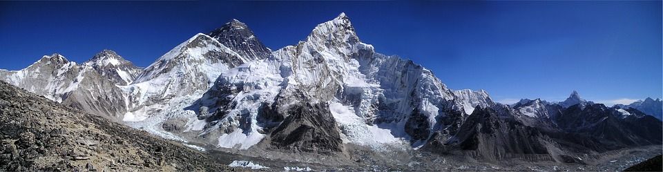
A corrie is a deep armchair-shaped hollow found in the side of mountains.
An arête is a ridge that forms between two corries that form beside each other.
A pyramidal peak is produced when there are corries on all sides of a mountain, giving the peak a sharp appearance.
All of these landforms are macro-scale landforms.
Corries are formed where glaciers begin.
Corries are formed when snow in high altitude regions becomes compacted and dense.
Once snow builds up, nivation/snow pack erosion occurs. This enlarges the hollow, forming a nivation hollow (a periglacial feature).
Positive feedback occurs in the nivation hollow and it begins to accumulate more snow, enlarging the hollow further.
When the ice moves away due to gravity, it carves out a section of the mountainside.
It does this through the action of plucking on the back wall.
The rotational force of the ice causes greater pressure on the base of the hollow.
Corries usually form on the side of the mountain that receives the least sunshine due to the lower temperatures. In the UK, this is usually the northeast side of mountains.
Corries have deep depressions when glaciers begin to move away. These can fill with water to form glacial lakes (tarns).

Page 3
Glacial Troughs
The traditional shape of a river valley before glaciation is a V-shaped valley.
During glaciation, glaciers usually move down the easiest path. This is usually the existing river valley.
Large glaciers tearing away the sides and bottom of the previous valley give it a completely different shape.
Glacial valleys are usually U-shaped and are referred to as glacial troughs.
Glacial troughs are an example of a macro-scale landform.
The tributaries that once flowed gradually into the river valley now exit abruptly, entering the glacial trough as if it were a cliff. This cliff is referred to as a hanging valley.
Truncated spurs form when a glacier cuts through the existing interlocking spurs formed by the river.
Glacial troughs usually have a stepped profile, reflecting differential erosion as a result of irregularities in the bedrock and variations in the intensity of erosion. This forms successive basins down a glacial trough, separated by riegels/rock steps.
Longer glacial troughs can contain ribbon lakes.
When sea level rises, water can fill glacial troughs, forming fjords.

Page 4
Ribbon Lakes
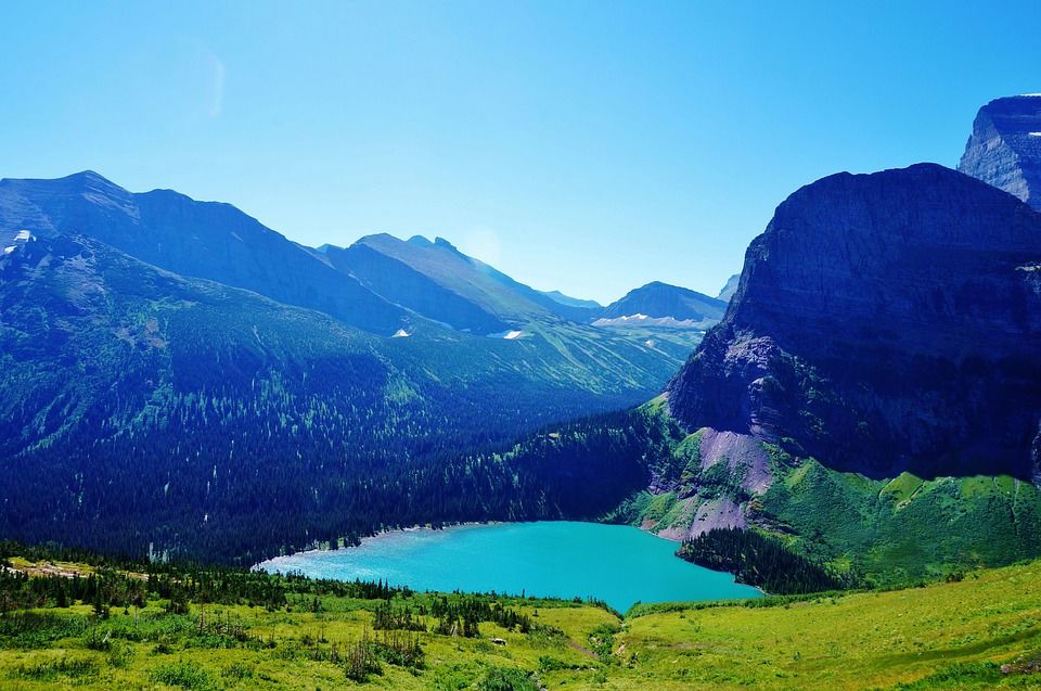
A ribbon lake is a long and narrow glacial lake, usually found in a glacial trough.
These form when a glacier moves over alternating bands of hard and soft rock.
The softer rock is eroded quicker by the glacier, creating dips in the surface.
When the glacier melts, these areas will fill with water first, creating the lake.
Page 5
Roche Moutonées
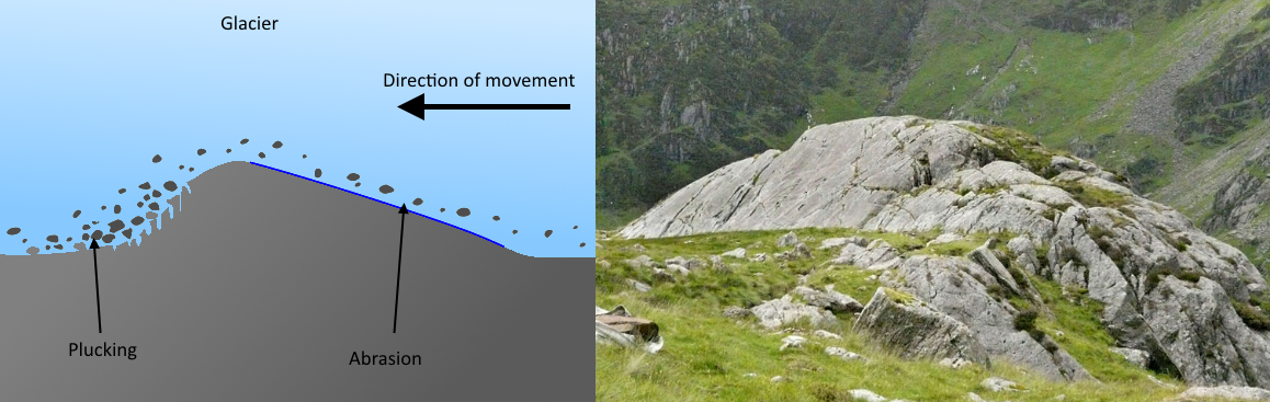
Roche moutonées are small rocky outcrops that vary in size.
These form from an outcrop of resistant rock that was left behind with the glacier passing.
The glacier slows upon meeting it and melting occurs.
As the ice moves again, the material is dragged down through the process of plucking.
These have a smooth upstream slope.
The area surrounding roche moutonées is called a knock and lochan landscape.
Roche moutonées are meso-scale features.
Page 6
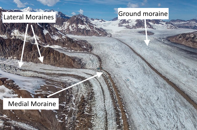
Moraines
Moraines formed beneath a glacier are referred to as subglacial.
Moraines formed along the margins of a glacier are referred to as ice-marginal.
Lateral moraines are ridges of deposited material that runs along the edges of a glacial trough.
Exposed rock on the valley side is weathered and fragments fall down onto the edge of the glacier. This is then carried along the valley and deposited when the ice melts.
Formed parallel to the ice flow.
Ground moraines are deposits of the material lodged under a glacier.
Ground moraines cover large areas of the UK.
The load of material that is bulldozed at the front of the glacier forms a terminal moraine.
These allow us to figure out how far glaciers moved during the ice age.
The up-valley side is generally steeper than the other side as the advancing ice rode over the debris.
Formed transverse to the ice flow.
Medial moraines form where glaciers meet.
They are formed where two lateral moraines are joined together to make a large ridge of rock debris.
Formed parallel to the ice flow.
Recessional moraines are a series of ridges running across the valley behind the terminal moraine.
They form when ice retreats and is brought to a stand-still.
They are good indicators of the cycle of advance and retreat.
Formed transverse to the ice flow.
Hummocky moraines are a chaotic jumble of glacial till.
These form when ice stops moving and the debris is dropped randomly.
They generally point in the same direction.
Page 7
Drumlins
Drumlins are egg-shaped, elongated platforms made out of glacial till.
They form when glaciers are blocked by an obstruction and material is deposited by the glacier as a ground moraine.
This material is then shaped by the moving ice.
Drumlins range in size, but can be up to 1km in length, 500m in width, and 50m high.
Drumlins are often found in groups called swarms.
The direction of previous ice movement is shown by drumlins.
Drumlins are an example of equifinality - they closely resemble hummocky moraines but are formed slightly differently.

Page 8
Crag and Tail
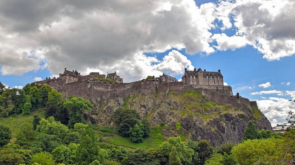
Crags form where a glacier meets a resistant rock or volcanic plug.
The glacier passes over the rock but leaves it standing, eroding the softer rock around it.
Material is deposited on the lee slope (the steepest point of the feature) and tapers away with distance.
Edinburgh Castle is built on a crag, as seen in the image below.
Page 9
Erratics
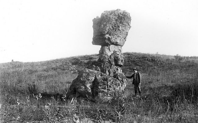
Erratics are rocks that differ in size and type from the area they're sitting in.
Glaciers can pick up large rocks and carry them hundreds, sometimes thousands, of kilometres from where they were formed.
Erratics are usually carried deep in the ice and so do not wear down like the rocks at the edges. This is how they retain their size.
Information
- Description
- User has deleted their subject information Note on Glacial Landforms: A-Level Geography, created by Deleted user on 15/08/2017.
- Created by
- Deleted user · Aug 2017
- Updated
- Aug 15, 2017
- Views
- 113
- History
-
- Created by Antonia Blankenberg · Jun 22, 2017
- Copied by Antonia Blankenberg · Aug 10, 2017
- Copied by Antonia Blankenberg · Aug 15, 2017
- Rating