16265870
Descripción
Test por Kirsten KinneyGrass, actualizado hace más de 1 año
|
|
Creado por Kirsten KinneyGrass
hace más de 5 años
|
|
Pregunta 1
Pregunta
Cognitive images(mental maps) can be based on
Respuesta
-
visual representations of actual locations, direct experiences, and people's imaginations
-
visual representations of actual locations
-
direct experiences
-
only a direct experience and visual representations of actual locations
-
people's imaginations
Pregunta 2
Pregunta
Maps that adjust the size of area units based on the values of the data they depict are called
Respuesta
-
topographic maps
-
flow-line maps
-
satellite images
-
cartogram maps
-
choropleth maps
Pregunta 3
Pregunta
The state of Texas is BEST considered a formal region because
Respuesta
-
the same state laws apply everywhere in the region
-
religion is the same everywhere in the region
-
transportation systems converge in the major highways of the region
-
only one language is spoken in most of the cities of the region
-
it is a part of the United States
Pregunta 4
Pregunta
Relative to lines of latitude near the equator, lines of latitude neat the poles are
Respuesta
-
shorter
-
More accurate
-
Straighter
-
Longer
-
Wider
Pregunta 5
Pregunta
Regarding Chicago, which statement is best describing its relative location
Respuesta
-
Its location is affected by rail road lines through the central U.S. and transport on the Great Lakes
-
It has a specific latitiude and longitude
-
It is located in the northern hemisphere, northwest of the origin of latitude and longitude
-
It is found north of the Equator and west of the Prime Meridian
Pregunta 6
Pregunta
How are a cartogram and a graduated symbol map similar?
Respuesta
-
Both indicate exact locations of specific data precisely
-
Both display latitude and longitude acurately
-
Both are useful for comparing the physical area of a country
-
Both portray numerical data for comparison between places
-
Both provide a good compromise among distortions of shape, size, direction, and distance
Pregunta 7
Pregunta
The Kinshasa Highway, also known as the AIDS Highway, is an informal highway that goes from coast to coast in Africa. This highway has played a significant role in minimizing:
Respuesta
-
Sense of place
-
Friction of distance
-
Connectivity
-
Distance decay
-
Spatial interaction
Pregunta 8
Pregunta
The location of Chicago at 41 degrees 49' N latitude and 87 degrees 37' W longitude is an example of
Respuesta
-
GPS location
-
Absolute location
-
Intensive location
-
Remote location
-
Relative location
Pregunta 9
Pregunta
A hearth is
Respuesta
-
a region from whcihc a phenomenon originates
-
the perimeter or boundary marked by a regional feature
-
the modification of a culture as a result of contact with a more powerful one
-
the process by which a feature or trend spreads
-
an area defined by one or more distinctive features or trends
Pregunta 10
Pregunta
Huricane Katrina's landfall on the United States is an interesting geographic cas study because
Respuesta
-
the federal government was poorly prepared for the storm and its aftermath
-
its effects are an intersection of human and physcal geography
-
people of all ethnic and racial groups were equally devastated by the storm
-
the damage was largely a result of flooding from rivers and a storm surge, not the winds
-
its winds reached incredible speed near the eye of the hurricane
Pregunta 11
Pregunta
Which of the following are forms of expansion diffusion?
Respuesta
-
relocation and stimulus
-
contagious and eponymous
-
contagious and hierarchical
-
hierarchical and formal
-
economis and relocation
Pregunta 12
Pregunta
Friction of distance
Respuesta
-
is now considered an outdated concept with little current utility
-
is the reflection of only cost overcoming distance
-
is another term for the distance-decay function
-
is usually negligible over distances of less that ten miles
-
is dependent in part upon an individual's cognitive distance
Pregunta 13
Pregunta
The statement, "Mexico's location next to the United States has had a great impact on its economic development," suggests that Mexico's economic development is related to its
Respuesta
-
spatial interaction
-
sense of place
-
situation
-
site
-
cognitive distance
Pregunta 14
Pregunta
On the tropical rainforest island of Borneo, some tribes practice slash-and-burn agriculture, while other tribes have chosen to be fishers. This exemplifies
Respuesta
-
possibilism
-
determinism
-
adoption
-
culturism
-
diffusion
Pregunta 15
Pregunta
Hawaii's tropical location, sandy beaches, volcanoes, volcanic soils, and plentiful moisture play an important role in its economic activities. In terms of its relative locaation, these characteristics refer to Hawaii's
Respuesta
-
space
-
situation
-
place
-
site
-
distance
Pregunta 16
Pregunta
An example of a map that is a compromise between an wqual-area and conformal projection is
Respuesta
-
a satellite image
-
the Mercator projection
-
the Robinsion projecton
-
the sinsusoidal projecton
-
a peace map
Pregunta 17
Pregunta
Which of the following are lines of constant value?
Respuesta
-
cartograms
-
isolines
-
GPS lines
-
smooth lines
-
projection lines
Pregunta 18
Pregunta
Spatial association requires geographer to look at the distribution of phenomena
Respuesta
-
only at a state scale
-
on a global and national scale only
-
on a national, state, and urban(local) scale
-
only on a national scale
-
at a global scale
Pregunta 19
Pregunta
The migration of Europeans into the Western Hemisphere included those people introducing Christianity into the Americas, thereby illustrating the process of this type of diffusion.
Respuesta
-
contagious
-
stimulus
-
relational
-
relocation
-
hierarchical
Pregunta 20
Pregunta
Which of the following best describes the site of Mexico City?
Respuesta
-
the most important financial and political center in Mexico
-
the federal district of Mexico
-
an important node in a global system of flows of goods, information, and people
-
a highland valley and dry lakebed located on a high plateau in southern central Mexico
-
an urban area located aproximately two hours from Houston, Texas, by airplane
Pregunta 21
Pregunta
Which of the following is most likely a functional region?
Respuesta
-
the area of dominance of a church or sect
-
area where people tend to be fans of a particular professional football team
-
the area of dominance of a television station
-
the area that a person regards as a hometown
-
an area where new ideas seem to be circulating the fastest
Pregunta 22
Pregunta
An example of a formal region is
Respuesta
-
the area of France where the Breton language is spoken
-
Dixie
-
an incredibly pleasant mountain
-
the hub and spoke network for a particular airline
-
100,000 square kilometers
Pregunta 23
Pregunta
Of the following, the best example of a functional region is
Respuesta
-
Chicago
-
the West Coast
-
North America
-
Cajun Country
-
the Corn Belt
Pregunta 24
Pregunta
Mormonism is most concentrated in the counties surronding Salt Lake City, Utah, and teh population of Mormons as a percentage of total county population begins to decline the further away from Salt Lake City. This is an example of
Respuesta
-
time space compression
-
assimilation
-
syncretism
-
distance decay
-
acculturation
Pregunta 25
Pregunta
A computer system that stores, organizes, retrives, analyzes, and displays geofraphic data is
Respuesta
-
USGS
-
remote sensing
-
topographic analysis
-
GIS
-
GPS
Pregunta 26
Pregunta
The belief that the physical enviorment is the dominant force shaping cultures and that humankind is essentially a passive product of its physical surrounding is known as
Respuesta
-
cultural determinism
-
possibilism
-
veganism
-
landscape enviormentalism
-
enviormental determinism
Pregunta 27
Pregunta
"The paving of Kinshasa Highway affected every person on earth, and turned out to be one of the most important events of the twentieth century. It has already cost at least 10 million lives, with the likelihood that the ultimate number of human casualties will vastly exceed the deaths in the Second World War"
The quote from the Hot Zone reflects a downside of:
Respuesta
-
location
-
globalization
-
site
-
proximity
-
sense of place
Pregunta 28
Pregunta
The people of Siberia domesticated reindeer afer learnin gabout cattle being domesticates by people to their south. This is an example of which type of diffusion?
Respuesta
-
hierarchical
-
contagious
-
vernacular
-
stimulus
-
relocation
Pregunta 29
Pregunta
Which of the following is the largest scale map?
Respuesta
-
1: 63,360
-
1: 24,000
-
1: 8,000
-
1: 50,000
Pregunta 30
Pregunta
The distortion shown in the image best represents what projection type?
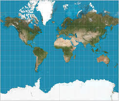
Respuesta
-
Conic
-
Peters
-
Mercator
-
Robinson
-
Mollweide
Pregunta 31
Pregunta
The brand Under Armour is an example of which type of diffusion?
Respuesta
-
hierarchical
-
relocation
-
contagious
-
stimulus
-
formal
Pregunta 32
Pregunta
The two images reflect what concept of map scale?
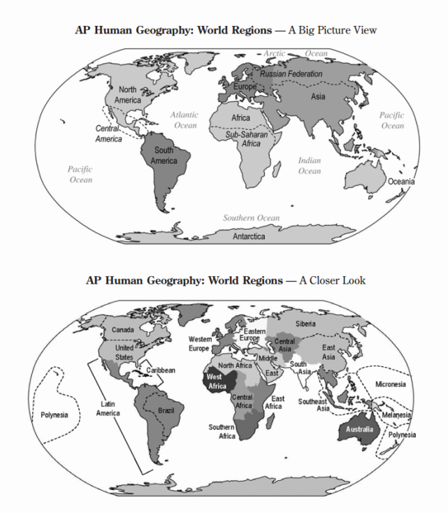
Respuesta
-
aggregation
-
simplification
-
map choice
-
scale of analysis
-
ratio of distance
Pregunta 33
Pregunta
Though we often talk about the 'South', speak of 'southern hospitality' and mention that people have southern accents
Respuesta
-
the south is nto very different from the north
-
the south does not generally include Georgia or Florida
-
the south, as a region, is very difficult to define
-
today Michigan and Wisconsin are included in the region
Pregunta 34
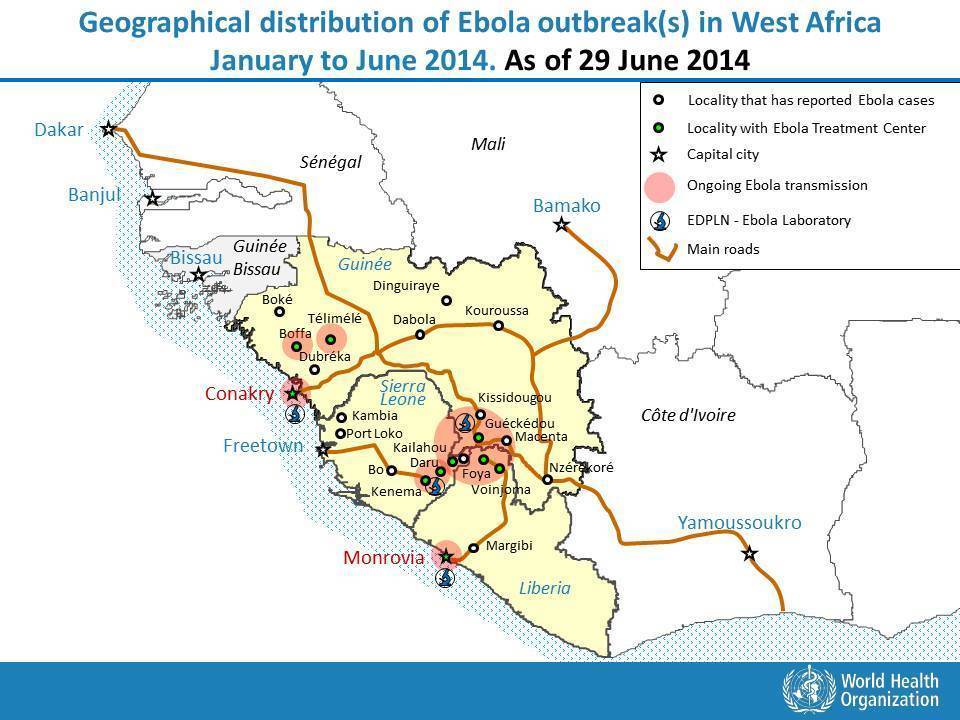
Respuesta
-
epidemic
-
human-environment interactions
-
pandemic
-
location theory
-
sequent occupance
Pregunta 35
Pregunta
Jews who were expelled from Spain in 1492 brought their religious beliefs and practices to the new areas in which they settled. This is a case of
Respuesta
-
contagious diffusion
-
relocation diffusion
-
hierarchical diffusion
-
expansion diffusion
-
relational diffusion
Pregunta 36
Pregunta
While at opposite ends of the emotional spectrum, a joke spreading quickly throughout an office and cholers claiming a victim from every household in a village are both examples of which type of diffusion?
Respuesta
-
hierarchical
-
vernacular
-
relocation
-
contact
-
contagious
Pregunta 37
Pregunta
One way that possibilism differs from enviormental determinism is that it emphasizes:
Respuesta
-
culture
-
history
-
regions
-
trade
-
climate
Pregunta 38
Pregunta
Distance decay implies that
Respuesta
-
short distances erode hierarchical diffusion
-
long-distance interactions are more likely that short-distance interactions
-
long distances erode hierarchical diffusion
-
carrying fruit for a long distance causes it to rot
-
short-distance interactions are more likely than long-distance interactons
Pregunta 39
Pregunta
A mental map is a good way to represent what type of region?
Respuesta
-
vernacular region
-
political region
-
economic region
-
formal region
-
functional region
Pregunta 40
Pregunta
As geographers use the term, scale tells us
Respuesta
-
the length of a degree of longitude along different parallels
-
the intrinsic character of the object or area studied
-
the relationship between earth distance and map distance
-
the smoothness of a snake or fish
-
the weight of a given commodity
Pregunta 41
Pregunta
The arrangement of a phenomenon across Earth's surface is
Respuesta
-
spatial analysis
-
dispersal
-
spatial association
-
distribution
-
regional dissociation
Pregunta 42
Pregunta
Which of the following correctly lists the four main properties of maps?
Respuesta
-
area, direction, latitude, longitude
-
the USA, China, Africa, and New Zealand
-
area, shape, distance, direction
-
conformality, equivalence, direction, symbols
-
equivalence, shape, latitude, longitude
Pregunta 43
Pregunta
The projection used during the Cold War to exaggerate the Communist threat by distorting the areas of countries at high latitudes
Respuesta
-
the Stalin projection
-
the Robinson projecton
-
cartogram
-
the Mercator projection
-
Goode's Homolosine projection
Pregunta 44
Pregunta
A map projection may distort a continent, making it appear stretched in some areas and smashed in others in order to
Respuesta
-
depict accurately the shape of that same continent
-
distort the shapes of other continents
-
distort the distances and relatice sizes of countries and continents
-
depict accurately the physical area of a country or continent
-
depict a map that accurately represents a globe in every detail
Pregunta 45
Pregunta
This image is a desire line map recording the daily volume of daily work trips within the San Francisco Bay area to the Silicon Valley employment node. What is best represented by this?
Respuesta
-
density
-
distance
-
site
-
time-space compression
-
spatial interaction
Pregunta 46
Pregunta
Which state has seen the largest amount of population increase 2000-2010?
Image:
Nevada (binary/octet-stream)
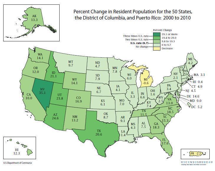
Respuesta
-
Florida
-
Nevada
-
Texas
-
Arizona
-
California
Pregunta 47
Pregunta
Which of the following provides a strong relationship between land and water areas in the world and does not distort countries at high latitudes?
Respuesta
-
Robinson projection
-
Mercator projection
-
Mollweide projection
-
Van Der Grinten projection
-
All maps distort at high latitudes
Pregunta 48
Pregunta
It is believed that a certain plant was domesticated in 2 different parts of the world, at 2 different times, by 2 cultures that never had contact with each other. The domestication of this plant can be considered a case of
Respuesta
-
contagious diffusion
-
independent invention
-
relocation diffusion
-
nodal interaction
-
plant plagiarism
Pregunta 49
Pregunta
The primary source of diffusion today is
Respuesta
-
the internet
-
political elections
-
global business
-
snitches
-
missionary work
Pregunta 50
Pregunta
Spatial interaction is affected by
Respuesta
-
the physical enviornment, the cultural lanscapr, and the interchange potential of places
-
distance, accessibility, and connectivity
-
mobility, economics, and anticipation
-
shaking hands, high-fiving, and hugging
-
absolute location, spatial parameters, and network design
¿Quieres crear tus propios Tests gratis con GoConqr? Más información.