
Mapa mental
Deforestation in Malaysia
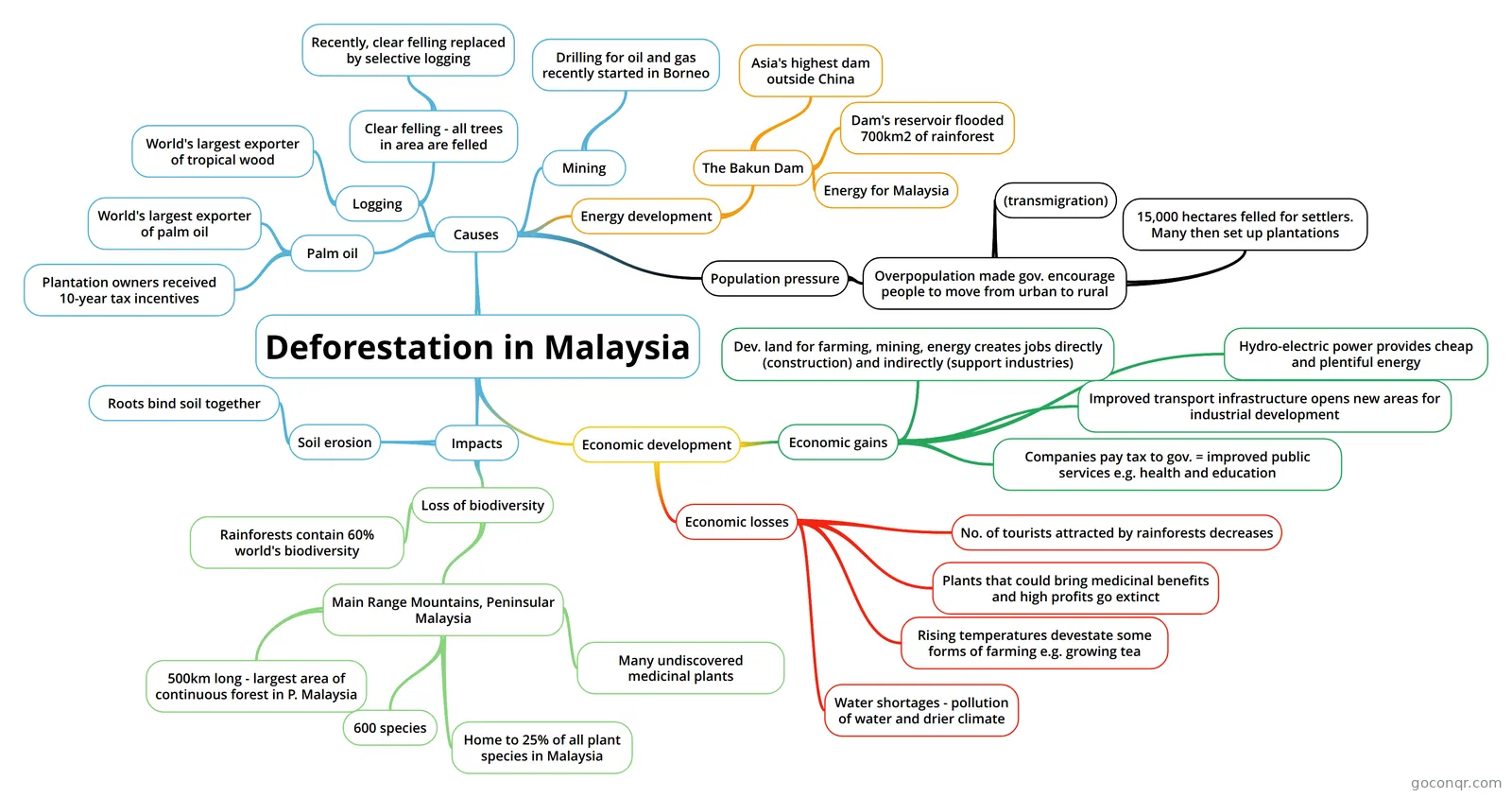
Mind map: Deforestation in Malaysia
Contenido del mapa
Deforestation in Malaysia
Causes
- Logging
- World's largest exporter of tropical wood
- Clear felling - all trees in area are felled
- Recently, clear felling replaced by selective logging
- Mining
- Drilling for oil and gas recently started in Borneo
- Energy development
- The Bakun Dam
- Asia's highest dam outside China
- Dam's reservoir flooded 700km2 of rainforest
- Energy for Malaysia
- The Bakun Dam
- Palm oil
- World's largest exporter of palm oil
- Plantation owners received 10-year tax incentives
- Population pressure
- Overpopulation made gov. encourage people to move from urban to rural
- (transmigration)
- 15,000 hectares felled for settlers. Many then set up plantations
- Overpopulation made gov. encourage people to move from urban to rural
- Logging
Impacts
- Soil erosion
- Roots bind soil together
- Loss of biodiversity
- Rainforests contain 60% world's biodiversity
- Main Range Mountains, Peninsular Malaysia
- 500km long - largest area of continuous forest in P. Malaysia
- 600 species
- Home to 25% of all plant species in Malaysia
- Many undiscovered medicinal plants
- Soil erosion
Economic development
- Economic losses
- Water shortages - pollution of water and drier climate
- Rising temperatures devestate some forms of farming e.g. growing tea
- Plants that could bring medicinal benefits and high profits go extinct
- No. of tourists attracted by rainforests decreases
- Economic gains
- Dev. land for farming, mining, energy creates jobs directly (construction) and indirectly (support industries)
- Companies pay tax to gov. = improved public services e.g. health and education
- Hydro-electric power provides cheap and plentiful energy
- Improved transport infrastructure opens new areas for industrial development
- Economic losses
Información
- Descripción
- GCSE Geography Mapa Mental sobre Deforestation in Malaysia, creado por Alex Nam el 18/05/2019.
- Creado por
- Alex Nam
- Visitas
- 0
- Valoración