
Mapa mental
Natural Disasters
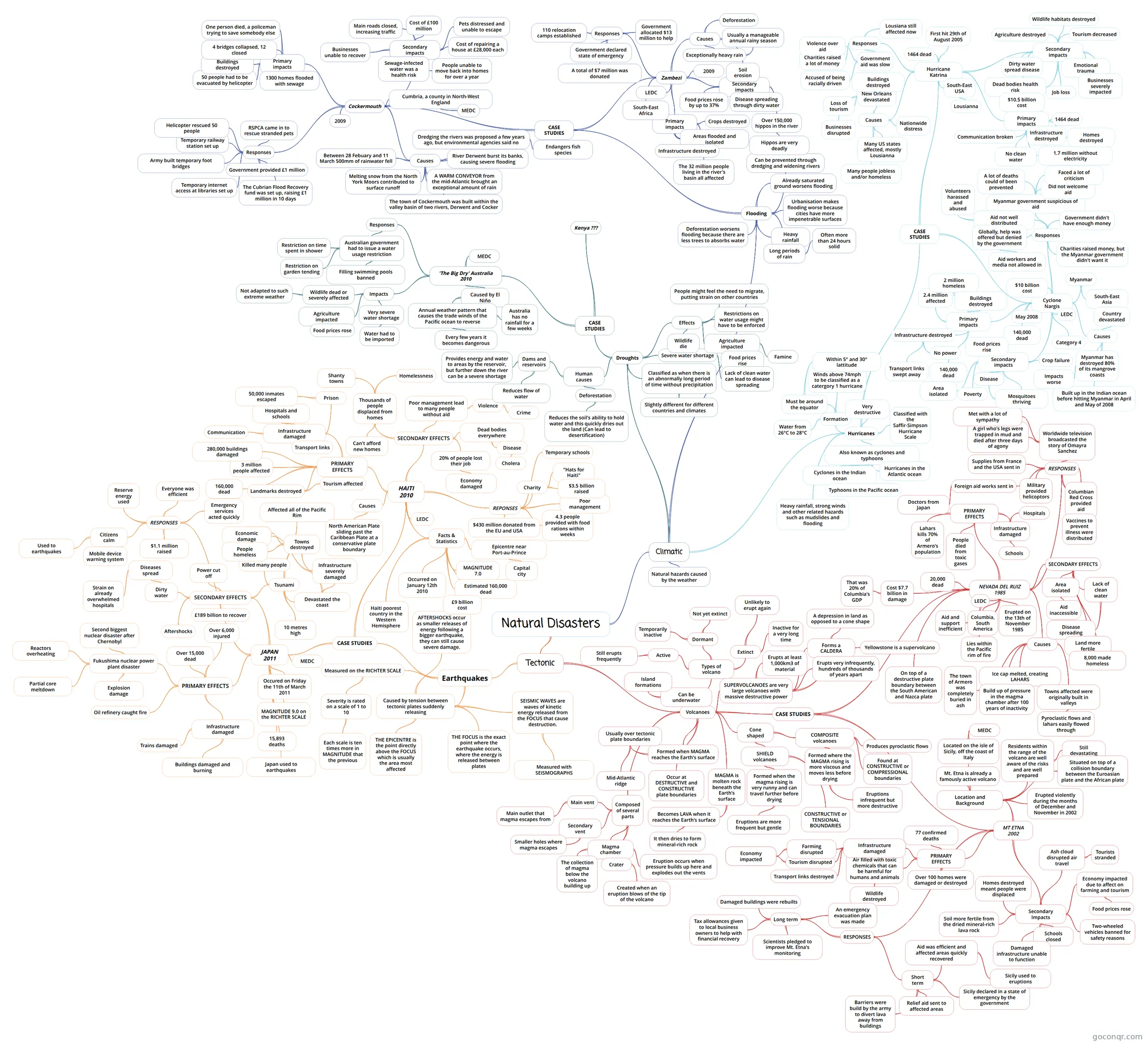
Mind map: Natural disasters
Contenido del mapa
Natural Disasters
- http://www.bbc.co.uk/schools/gcsebitesize/geography/natural_hazards/
Tectonic
- Earthquakes
- Caused by tension between tectonic plates suddenly releasing
- THE FOCUS is the exact point where the earthquake occurs, where the energy is released between plates
- THE EPICENTRE is the point directly above the FOCUS which is usually the area most affected
- SEISMIC WAVES are waves of kinetic energy released from the FOCUS that cause destruction.
- Measured with SEISMOGRAPHS
- AFTERSHOCKS occur as smaller releases of energy following a bigger earthquake, they can still cause severe damage.
- Measured on the RICHTER SCALE
- Severity is rated on a scale of 1 to 10
- Each scale is ten times more in MAGNITUDE that the previous
- Severity is rated on a scale of 1 to 10
- CASE STUDIES
- JAPAN 2011
- Occured on Friday the 11th of March 2011
- MAGNITUDE 9.0 on the RICHTER SCALE
- 15,893 deaths
- PRIMARY EFFECTS
- Infrastructure damaged
- Buildings damaged and burning
- Trains damaged
- Oil refinery caught fire
- Fukushima nuclear power plant disaster
- Partial core meltdown
- Explosion damage
- Reactors overheating
- Second biggest nuclear disaster after Chernobyl
- Over 15,000 dead
- Over 6,000 injured
- Infrastructure damaged
- SECONDARY EFFECTS
- Tsunami
- Devastated the coast
- Infrastructure severely damaged
- Economic damage
- Towns destroyed
- People homeless
- Infrastructure severely damaged
- 10 metres high
- Killed many people
- Affected all of the Pacific Rim
- Devastated the coast
- Power cut off
- Dirty water
- Diseases spread
- Strain on already overwhelmed hospitals
- Diseases spread
- Aftershocks
- £189 billion to recover
- Tsunami
- MEDC
- Japan used to earthquakes
- RESPONSES
- Citizens calm
- Used to earthquakes
- Mobile device warning system
- $1.1 million raised
- Emergency services acted quickly
- Everyone was efficient
- Reserve energy used
- Citizens calm
- HAITI 2010
- https://handygeography.wordpress.com/gcse/the-restless-earth-revision-materials/earthquake-case-study-haiti-poor/
- Facts & Statistics
- MAGNITUDE 7.0
- Occurred on January 12th 2010
- Estimated 160,000 dead
- Epicentre near Port-au-Prince
- Capital city
- Haiti poorest country in the Western Hemisphere
- £9 billion cost
- LEDC
- PRIMARY EFFECTS
- Landmarks destroyed
- Tourism affected
- 160,000 dead
- 3 million people affected
- 280,000 buildings damaged
- Infrastructure damaged
- Transport links
- Communication
- Hospitals and schools
- Prison
- 50,000 inmates escaped
- Landmarks destroyed
- SECONDARY EFFECTS
- 20% of people lost their job
- Economy damaged
- Dead bodies everywhere
- Disease
- Cholera
- Disease
- Poor management lead to many people without aid
- Violence
- Crime
- Violence
- Thousands of people displaced from homes
- Homelessness
- Shanty towns
- Can't afford new homes
- 20% of people lost their job
- REPONSES
- Charity
- "Hats for Haiti"
- $3.5 billion raised
- $430 million donated from the EU and USA
- 4.3 people provided with food rations within weeks
- Poor management
- Temporary schools
- Charity
- Causes
- North American Plate sliding past the Caribbean Plate at a conservative plate boundary
- JAPAN 2011
- Caused by tension between tectonic plates suddenly releasing
- Volcanoes
- Formed when MAGMA reaches the Earth's surface
- Usually over tectonic plate boundaries
- Mid-Atlantic ridge
- Usually over tectonic plate boundaries
- CASE STUDIES
- NEVADA DEL RUIZ 1985
- http://www.slideshare.net/Ruth1618/nevado-del-ruiz-case-study http://www.slideshare.net/thepack001/nevado-del-ruiz-volcano-case-study
- LEDC
- Aid and support inefficient
- Erupted on the 13th of November 1985
- Columbia, South America
- Lies within the Pacific rim of fire
- Causes
- Ice cap melted, creating LAHARS
- Build up of pressure in the magma chamber after 100 years of inactivity
- The town of Armero was completely buried in ash
- Towns affected were originally built in valleys
- Pyroclastic flows and lahars easily flowed through
- On top of a destructive plate boundary between the South American and Nazca plate
- 20,000 dead
- PRIMARY EFFECTS
- Infrastructure damaged
- Schools
- Hospitals
- Lahars kills 70% of Armero's population
- People died from toxic gases
- Infrastructure damaged
- SECONDARY EFFECTS
- Area isolated
- Aid inaccessible
- Lack of clean water
- Disease spreading
- Land more fertile
- 8,000 made homeless
- Area isolated
- Cost $7.7 billion in damage
- That was 20% of Columbia's GDP
- RESPONSES
- Columbian Red Cross provided aid
- Military provided helicoptors
- Vaccines to prevent illness were distributed
- Foreign aid works sent in
- Doctors from Japan
- Supplies from France and the USA sent in
- Worldwide television broadcasted the story of Omayra Sanchez
- A girl who's legs were trapped in mud and died after three days of agony
- Met with a lot of sympathy
- MT ETNA 2002
- Location and Background
- Mt. Etna is already a famously active volcano
- Located on the isle of Sicily, off the coast of Italy
- MEDC
- Residents within the range of the volcano are well aware of the risks and are well prepared
- Still devastating
- Erupted violently during the months of December and November in 2002
- Situated on top of a collision boundary between the Euroasian plate and the African plate
- PRIMARY EFFECTS
- Over 100 homes were damaged or destroyed
- Air filled with toxic chemicals that can be harmful for humans and animals
- Wildlife destroyed
- Infrastructure damaged
- Tourism disrupted
- Economy impacted
- Farming disrupted
- Economy impacted
- Transport links destroyed
- Tourism disrupted
- 77 confirmed deaths
- Secondary Impacts
- Ash cloud disrupted air travel
- Tourists stranded
- Economy impacted due to affect on farming and tourism
- Food prices rose
- Schools closed
- Two-wheeled vehicles banned for safety reasons
- Damaged infrastructure unable to function
- Soil more fertile from the dried mineral-rich lava rock
- Homes destroyed meant people were displaced
- Ash cloud disrupted air travel
- RESPONSES
- Short term
- Sicily declared in a state of emergency by the government
- Relief aid sent to affected areas
- Barriers were build by the army to divert lava away from buildings
- Aid was efficient and affected areas quickly recovered
- Sicily used to eruptions
- Long term
- Tax allowances given to local business owners to help with financial recovery
- Damaged buildings were rebuilts
- Scientists pledged to improve Mt. Etna's monitoring
- An emergency evacuation plan was made
- Short term
- Location and Background
- NEVADA DEL RUIZ 1985
- Occur at DESTRUCTIVE and CONSTRUCTIVE plate boundaries
- MAGMA is molten rock beneath the Earth's surface
- Becomes LAVA when it reaches the Earth's surface
- It then dries to form mineral-rich rock
- Becomes LAVA when it reaches the Earth's surface
- Cone shaped
- SHIELD volcanoes
- Formed when the magma rising is very runny and can travel further before drying
- Eruptions are more frequent but gentle
- CONSTRUCTIVE or TENSIONAL BOUNDARIES
- Formed when the magma rising is very runny and can travel further before drying
- COMPOSITE volcanoes
- Formed where the MAGMA rising is more viscous and moves less before drying
- Eruptions infrequent but more destructive
- Found at CONSTRUCTIVE or COMPRESSIONAL boundaries
- Produces pyroclastic flows
- Formed where the MAGMA rising is more viscous and moves less before drying
- SHIELD volcanoes
- Can be underwater
- Island formations
- Types of volcano
- Active
- Still erupts frequently
- Dormant
- Temporarily inactive
- Not yet extinct
- Extinct
- Inactive for a very long time
- Unlikely to erupt again
- Active
- Composed of several parts
- Secondary vent
- Smaller holes where magma escapes
- Main vent
- Main outlet that magma escapes from
- Magma chamber
- The collection of magma below the volcano building up
- Eruption occurs when pressure builds up here and explodes out the vents
- Crater
- Created when an eruption blows of the tip of the volcano
- Secondary vent
- SUPERVOLCANOES are very large volcanoes with massive destructive power
- Erupts at least 1,000km3 of material
- Forms a CALDERA
- A depression in land as opposed to a cone shape
- Erupts very infrequently, hundreds of thousands of years apart
- Yellowstone is a supervolcano
- Formed when MAGMA reaches the Earth's surface
- Earthquakes
Climatic
- Hurricanes
- http://www.bbc.co.uk/bitesize/ks3/geography/physical_processes/weather_climate/revision/9/
- CASE STUDIES
- Cyclone Nargis
- Primary impacts
- 140,000 dead
- 2.4 million affected
- Infrastructure destroyed
- Transport links swept away
- No power
- 2 million homeless
- Buildings destroyed
- Secondary impacts
- Mosquitoes thriving
- Disease
- Poverty
- Area isolated
- Food prices rise
- Crop failure
- Mosquitoes thriving
- Responses
- Myanmar government suspicious of aid
- Did not welcome aid
- A lot of deaths could of been prevented
- Faced a lot of criticism
- Aid not well distributed
- Volunteers harassed and abused
- Government didn't have enough money
- Globally, help was offered but denied by the government
- Aid workers and media not allowed in
- Charities raised money, but the Myanmar government didn't want it
- Myanmar government suspicious of aid
- Causes
- Myanmar has destroyed 80% of its mangrove coasts
- Impacts worse
- Built up in the Indian ocean before hitting Myanmar in April and May of 2008
- Country devastated
- Myanmar has destroyed 80% of its mangrove coasts
- May 2008
- Myanmar
- South-East Asia
- Category 4
- 140,000 dead
- $10 billion cost
- LEDC
- Primary impacts
- Hurricane Katrina
- http://www.bbc.co.uk/bitesize/ks3/geography/physical_processes/weather_climate/revision/10/
- Primary impacts
- Communication broken
- No clean water
- Infrastructure destroyed
- 1464 dead
- 1.7 million without electricity
- Homes destroyed
- Secondary impacts
- Dirty water spread disease
- Dead bodies health risk
- $10.5 billion cost
- Job loss
- Emotional trauma
- Businesses severely impacted
- Agriculture destroyed
- Tourism decreased
- Wildlife habitats destroyed
- Causes
- Many US states affected, mostly Lousianna
- New Orleans devastated
- Loss of tourism
- Businesses disrupted
- Buildings destroyed
- Many people jobless and/or homeless
- Nationwide distress
- Responses
- Government aid was slow
- Accused of being racially driven
- Violence over aid
- Charities raised a lot of money
- Lousiana still affected now
- Government aid was slow
- 1464 dead
- First hit 29th of August 2005
- South-East USA
- Lousianna
- Cyclone Nargis
- Also known as cyclones and typhoons
- Cyclones in the Indian ocean
- Typhoons in the Pacific ocean
- Hurricanes in the Atlantic ocean
- Formation
- Must be around the equator
- Within 5° and 30° lattitude
- Water from 26°C to 28°C
- Winds above 74mph to be classified as a catergory 1 hurricane
- Must be around the equator
- Heavy rainfall, strong winds and other related hazards such as mudslides and flooding
- Classified with the Saffir-Simpson Hurricane Scale
- Very destructive
- Droughts
- Classified as when there is an abnormally long period of time without precipitation
- Slightly different for different countries and climates
- Severe water shortage
- Lack of clean water can lead to disease spreading
- Human causes
- Deforestation
- Reduces the soil's ability to hold water and this quickly dries out the land (Can lead to desertification)
- Dams and reservoirs
- Reduces flow of water
- Provides energy and water to areas by the reservoir, but further down the river can be a severe shortage
- Deforestation
- Effects
- Wildlife die
- Agriculture impacted
- Food prices rise
- Famine
- Restrictions on water usage might have to be enforced
- People might feel the need to migrate, putting strain on other countries
- CASE STUDIES
- 'The Big Dry' Australia 2010
- Caused by El Niño
- Annual weather pattern that causes the trade winds of the Pacific ocean to reverse
- Australia has no rainfall for a few weeks
- Every few years it becomes dangerous
- Annual weather pattern that causes the trade winds of the Pacific ocean to reverse
- Impacts
- Very severe water shortage
- Water had to be imported
- Agriculture impacted
- Food prices rose
- Wildlife dead or severely affected
- Not adapted to such extreme weather
- Very severe water shortage
- Responses
- Australian government had to issue a water usage restriction
- Filling swimming pools banned
- Restriction on time spent in shower
- Restriction on garden tending
- Australian government had to issue a water usage restriction
- MEDC
- Caused by El Niño
- Kenya ???
- 'The Big Dry' Australia 2010
- Classified as when there is an abnormally long period of time without precipitation
- Natural hazards caused by the weather
- Flooding
- http://www.slideshare.net/geodebs/revision-pack-2014-gcse-geography-ocr-b
- CASE STUDIES
- Zambezi
- Primary impacts
- Areas flooded and isolated
- Infrastructure destroyed
- Crops destroyed
- The 32 million people living in the river's basin all affected
- Secondary impacts
- Food prices rose by up to 37%
- Disease spreading through dirty water
- Over 150,000 hippos in the river
- Hippos are very deadly
- Causes
- Exceptionally heavy rain
- Usually a manageable annual rainy season
- Deforestation
- Soil erosion
- Exceptionally heavy rain
- Responses
- Government declared state of emergency
- 110 relocation camps established
- Government allocated $13 million to help
- A total of $7 million was donated
- 2009
- LEDC
- South-East Africa
- Primary impacts
- Cockermouth
- http://www.acegeography.com/flooding-case-studies-gcse.html
- Causes
- A WARM CONVEYOR from the mid-Atlantic brought an exceptional amount of rain
- The town of Cockermouth was built within the valley basin of two rivers, Derwent and Cocker
- River Derwent burst its banks, causing severe flooding
- Melting snow from the North York Moors contributed to surface runoff
- Dredging the rivers was proposed a few years ago, but environmental agencies said no
- Endangers fish species
- Between 28 Febuary and 11 March 500mm of rainwater fell
- Responses
- Government provided £1 million
- The Cubrian Flood Recovery fund was set up, raising £1 million in 10 days
- Temporary railway station set up
- Helicopter rescued 50 people
- Temporary internet access at libraries set up
- Army built temporary foot bridges
- RSPCA came in to rescue stranded pets
- Primary impacts
- 1300 homes flooded with sewage
- 50 people had to be evacuated by helicopter
- Buildings destroyed
- 4 bridges collapsed, 12 closed
- One person died, a policeman trying to save somebody else
- Secondary impacts
- Sewage-infected water was a health risk
- People unable to move back into homes for over a year
- Cost of repairing a house at £28,000 each
- Pets distressed and unable to escape
- Main roads closed, increasing traffic
- Cost of £100 million
- Businesses unable to recover
- 2009
- Cumbria, a county in North-West England
- MEDC
- Zambezi
- Heavy rainfall
- Long periods of rain
- Often more than 24 hours solid
- Urbanisation makes flooding worse because cities have more impenetrable surfaces
- Deforestation worsens flooding because there are less trees to absorbs water
- Already saturated ground worsens flooding
- Can be prevented through dredging and widening rivers
- Hurricanes
Información
- Descripción
- GCSE (Natural Disasters) Geography Mapa Mental sobre Natural Disasters, creado por Isobel Lugg el 26/12/2015.
- Creado por
- Isobel Lugg
- Visitas
- 271
- Etiquetas
- Valoración