
Apuntes
Geography Unit 1 Test
Contenido del apunte (7)
Página 1
Geographers's Toolkit
A map represents earth's features drawn on a flat surface
Maps use symbols and colours to represent different things
Components of a Map
Title - What area is shown? What is the topic?
Legend - What do the symbols and colours mean?
Scale - How much does one cm measure on the ground?
Direction - Which way is the map facing? (N, S, E, W)
Boarder - What is apart of this map and what isn't?
Date of Publication - How new/old is this map?
Types of Maps:
Large Scale
Small area
A lot of detail
Small Scale
Large area
Little detail
General Purpose Maps
Uses symbols and colours to represent different things
Can be both small scale or large scale
Thematic Maps
Reveals geographic patterns
Digital Maps
On handheld devices
Geographic Information Systems (GIS)
Provides information about the physical and human world using layers
Latitude
Imaginary lines that measure the distance north or south of the equator (0 degrees)
All lines are 111 km apart
Also known as parallels
Longitude
Imaginary lines that measure the distance east or west of the Prime Meridian (0 degrees)
All lines begin or end at the poles (North/South)
Also known as meridians
Scale
Shows the relationship between the distance on the map and the actual distance on the earth's surface
Página 2
The Compass Rose (ALL 22.5 DEGREES APART)
N - 0 degrees or 360 degrees
NNE - 22.5 degrees
NE - 45 degrees
ENE - 67.5 degrees
E - 90 degrees
ESE - 112.5 degrees
SE - 135 degrees
SSE - 157.5 degrees
S - 180 degrees
SSW - 202.5 degrees
SW - 225 degrees
WSW - 247.5 degrees
W - 270 degrees
WNW - 292.5 degrees
NW - 315 degrees
NNW - 337.5 degrees
Página 3
Lines of Latitude and Longitude
Important Lines of Latitude
90 degrees North = North Pole
66.5 degrees North = Arctic Circle
23.5 degrees North = Tropic of Cancer
0 degrees = The Equator
23.5 degrees South = Tropic of Capricorn
66.5 degrees South = Antarctic Circle
90 degrees South = South Pole
Important Lines of Longitude
0 degrees = Prime Meridian
180 degrees = International Dateline
Página 4
Time Zones of Canada
Pacific Ocean to Atlantic Ocean
Pacific Time Zone - 1
Victoria, British Columbia
Whitehorse, Yukon
Mountain Time Zone - 2
Edmonton, Alberta
Yellowknife, Northwest Territories
Central Time Zone - 3
Regina, Saskatchewan
Winnipeg, Manitoba
Eastern Time Zone - 4
Toronto, Ontario
Ottawa, Ontario
Quebec City, Quebec
Atlantic Time Zone - 5
Fredericton, New Brunswick
Halifax, Nova Scotia
Charlottetown, Prince Edward Island
Iqaluit, Nunavut
Newfoundland Time Zone- 5:30
St. John's, Newfoundland
Página 5
Scale
Distance used on a map to represent the actual distance between two points on the ground
1 cm on a map can represent any distance on the ground
Always use a ruler when measuring distance and be as accurate as possible
cm to km = divide by 100 000
km to cm = multiply by 100 000
Linear Scale
The scale of the map is indicated by a line with numbers
Example: The length of a line is 2 cm; so for this map 2 cm on the map represents 1 km on the ground. Or 1 cm represents 0.5 km on the ground
Ratio Scale
This scale of the map is indicated by a ratio
Example:
1:50 000
1 cm on the ground represents 50 000 cm on the ground
But: 100 cm = 1m and 1 000 m = 1km
So: 100 000 cm = 1 km
To find the length in km represented by 1 cm on the map divide the right hand side of the ratio scale by 100 000
Examples:
1:100 000 = 1 cm represents 1 km
1:500 000 = 1 cm represents 5 km
1:1 000 000 = 1 cm represents 10 km
Statement Scale
As the name suggests, the scale is stated or written in full sentences
Examples:
1 cm represents 0.5 km
1 cm represents 190 km
Representative Fraction (RF)
This type of scale basically involves converting a ratio scale into a fraction
Example:
1:50 000 = 1/50 000
CAUTION
Both the top and bottom of a RF scale are expressed in cm
Also, the number "1" must always be the numerator of the fraction
ANY type of scale can be converted into a Representative Fraction
What is the major use for scale?
Determining actual distances by using a map
It is possible to calculate the actual distance between two points
Example:
Map distance = 3 cm, which represents "x" km
Scale = 1:19 000 000 (1 cm represents 190 km
If: 1 cm represents 190 km
And: 3 cm represents "x" km . . . then, by cross-multiplying
("x") x (1) = (3) x (190)
x = 570 km
Therefore, the distance between these points is 570 km
There are two ways of measuring distance on a map:
"As the Crow Flies"
This refers to the straight line distance between two points
Using paths or routes
You might be asked to measure the distance between two points using a highway, river, pathways, railroad, or other "routes"
Página 6
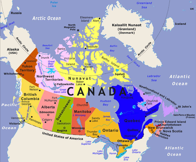
Provinces/Territories & Capital Cities
Canada = Ottawa
British Columbia = Victoria
Alberta = Edmonton
Saskatchewan = Regina
Manitoba = Winnipeg
Ontario = Toronto
Quebec = Quebec City
New Brunswick = Fredericton
Nova Scotia = Halifax
Prince Edward Island = Charlottetown
Newfoundland and Labrador = St John's
Yukon = Whitehorse
Northwest Territories = Yellowknife
Nunavut = Iqaluit
Página 7
Bodies of Water
Great Bear Lake
Great Salt Lake
Atlantic Ocean
Arctic Ocean
Pacific Ocean
Hudson's Bay
Lake Ontario
Lake Huron
Lake Michigan
Lake Erie
Lake Superior
Información
- Descripción
- - Latitude/Longitude - Scale - Time Zones - Parts of a Map - Large Scale vs Small Scale Maps
- Creado por
- Maddy Baker
- Visitas
- 187
- Etiquetas
- Valoración