
Flashcards
Remote Sensing Flashcards (2)
Cards in this deck (41)
- 1What is an additive color system?Use three principal colors to get all the colors: red green and blue
These three separate lights govern the intensity to give you all the colors, same with screens
We can't see 6 bands on the computer, only three bands, but we assign other bands one of these colors in order to make them apparent to us - 2What is a false compositeBecause we can only see 3 bands, we assign other bands picked up by the remote sense to make them apparent to us
- 3Why do we display near infrared as red?1. because humans are very sensitive to red (stop signs
2. Because those with color blindness can often see red, but not blue or green - 4Stretching an imageWe stretch an images reflectance values of 0-255 in order to eliminate the brightest and darkest values so images that are too dark or too light are scaled to catch the minor differences
- 5Exponential stretch (light)Lowest value at 50: Repress dark pixels to stretch light pixels
- 6Logarithmic stretch (dark)Lowest value at 50: but repress light pixels to stretch dark
- 7What is spatial filtering?Spatial frequency in remotely sensed imagery may be enhanced or subdued using two different approaches:
- Spatial convolution filtering based primarily on the use of convolution masks, and
- Fourier analysis which mathematically separates an image into its spatial frequency components. - 8What is a smoothing filterAKA low pass filter
surpasses high frequencies to eliminate salt and pepper noise - 9Median FilterUses the median of neighboring filters
- 10High pass filtersurpasses low frequencies to Accentuates the noise
- 11What is linear spatial filtering?compare a pixel to its neighbors replace the value with the mean of neighboring values, smooths out the detail (less fine)
The higher the value the more smooth the image - 12Name all types of spatial filteringHigh pass filtering: suppressing low frequencies to accentuate the noise
Low pass filtering: suppressing high frequencies to eliminate noise
Mean/Linear filtering: comparing neighboring pixels and getting their mean value
Median filtering: comparing neighboring pixels and getting their median value - 13What is Rectification?AKA geometric correction
Distortion is inherent to every image, if we were to lay the image over a map they wouldn’t line up
Need to rectify image by
1. - 14What is image to map rectification?Uses the coordinate system of an image to match it to the uncertified map
1. Find good GCP (uses coordinate systems either UTM (eastings and northings in m) or coordinate systems (lat long in degrees)- many - spread out - and obvious
2. Use a mathematical equation to find the relationship between the x y coordinates (using linear direct match or polynomial for air born images that have more distortion) - find error (error should be half a pixel)
3. make the new image using interpolation: nearest neighbor, bilingual, cubic convolution - 15What is more distorted: airplane photos or satellite imagery?Airplane photos: move more than satellites: up down, side to side
- 16What types of errors do we encounter?Random error: more for airplanes, plane rolls, pitches or drops, not predictable
Systematic error: found in satellites, as the satellite goes around the earth, it may be positioned askew: error is predictable and easy to fix - 17What is digital classification?Uses a number of pixels to cluster and identify them as a class by using spectral information
- 18What is supervised classification?Using our eyes to identify unique training errors to train the computer to look for similar areas throughout the map
- 19Qualities of good training areasUnique, many, no overlap
- 20What are the four types of supervised classification?Parametric
1. Density slicing: max/min but works on one band, works quickly but this technique allows for class overlap, not particularly good
2. Parallelepiped: mx/min but works on multiple bands but cannot recognize what a class is
3. Minimum (euclidian) distance: looks at the mean, most popular: looks at distance to the mean, classifies every single pixel based on this
Non-Parametric
4. Minimum likelihood: uses mean and standard deviation, but slowest to compute - 21What is unsupervised classification?Let the computer decide what the classes are using mathematical clusters:
1. looks at the radius of the classes
2. looks at how far apart they are from each other before they merge them
3. main output is map of clusters, need to name the classes - 22When would you use supervised vs unsupervised?Use supervised if you care about a particular class (like cedar)
Use unsupervised if you don't care about a particular class - 233 ways to check the accuracy of land classes in map1. Use random points to check
2. Use systematic points to check
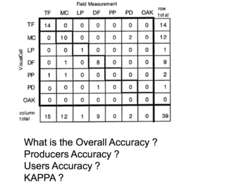
3. Stratified random: stratified to pick the classes you want to check, random to ensure you are getting a representative view - 24Draw a confusion matrix
- 25General history of photogramatic systemsMost countries started becoming mapped in world war II
Satellites are rigid, not terribly adaptable, can get more detail with aerial cameras - 26Describe the components of a camera
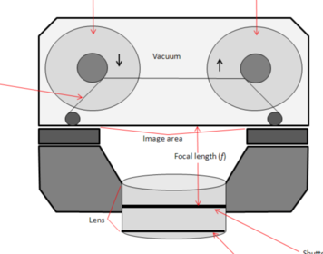
- 27What is the importance of the focal length?Important because it defines the scale of the photograph and the altitude of the plane above the ground
Ex: 1:50,000 - 1 cm is 50,000 cm
See broad features on one photograph
1:100,000 bigger area
The smaller the ratio, the bigger area (1:500) - 28What are the 2 types of aerial photographs?1. Vertical: straight down and within 3 degrees of variation,
scale is more even, can only use vertical for mapping because it looks straight down
2. Oblique: takes photos from the side
greater than 3 degrees, low oblique (no horizon) high oblique (see horizon - 29How do you get the focal length?Scale is the focal length, divided by the altitude of the plane
Another way: photo distance over ground distance - 30What is photogrammetry?The science of taking measurements from the photograph:
needs to be vertical
needs to have 60% overlap between sequential photos - 31Name and define the various characteristics in photogrammetry1. The Principal point: center of the photograph to the center of the sensor
2. Fiducial marks: help you find the principal point
3. Principal point: Point at which the film intersects the photograph (not total center, could be slightly off)
4. Conjugal principal point: principal point on another photograph - 32How you would use shape, patter, size, tone/color to interpret aerial photograph1. Shape (trees)
2. Texture (more natural looking trees)
• Randomness
• Water surface
3. Association (near water, wetter species of tree)
4. Shadow (height, time of day, shape of building)
5. Pattern: plantation vs forest (pattern is repeated)
6. Tone or colour: darker
7. Size: Young tree vs old tree - 33Difference between passive and active remote sensingPassive: photons are collected from the sun
Active: send out electrogmatnetic radiation and wait for pulses to come back, measure where and how long - 34Describe RADARRadio Detection (seeing) and Ranging (distance)
Very sensitive to the geometry of surface reflection - 35What are the 3 factors that govern the response of backscatter?Surface roughness: dominant
Dielectric properties: ability to pass energy through surface
Moisture content
Rule: only will interact with things the same size (p with p, x with x)
Can see through clouds, penetrate soil, can fly all day - 36What are the different names to measure the radar and microwave spectrum?• X (30 cm), C, L, P (6-cm)
X is shortest, best for leaves
6 is longest, best for forest - 37What is polarization?Control over sending waves by using grates in order to see two different images at once
4 different permutations of vertical and horizontal: vv, hh, vh, hv - 38List the different types of active sensor systemsRADAR: radio waves
Lidar: laser waves
Sonar: sound waves - 39Describe Canada's Radarsat?RAdarsat 1 no longer words, use Radarsat 2
Radar sat is C band
Used for topography, snow and bright surfaces - 40Describe LidarLight Detection and Ranging
What comes back, when it comes back
Sends out pulse and needs to know where it is to catch it using IMU
Good for detecting DEM
- Pulses come down, look at the last hit for information about the ground, but it will cause interactions with the forest, and gets reflected, little bits of lidar data as it passes through the canopy - 41What is the difference between Lidar and Radarcan’t see through the canopy, only gaps through the canopy
Information
- Description
- Flashcards on Remote Sensing Flashcards (2), created by kalifimoon on 18/04/2016.
- Created by
- kalifimoon
- Views
- 2
- Rating