
Mind map
River Processes and Landforms

Map content
River Processes and Landforms
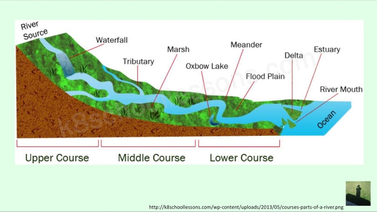
River Features
- Source
- The point where a river begins
- Tributary
- A small river or stream that joins up with a larger one
- Confluence
- The point at which a tributary joins the river
- Mouth
- The point where a river enters the sea
- River Basin
- An entire area drained by a river and its tributaries
- Watershed
- High ground that separates one river basin from another
- Source
Features of a river's course
- Upper Course
- The river has a steep gradient (slope)
- The valley has a narrow floor and steep sides
- Middle Course
- The river has a gentler gradient
- The valley has a wider floor and the sides are more gently sloping.
- Lower Course
- The river has an almost flat gradient
- The valley has a wide, flat floor and gentle sides
- Upper Course
River processes of Erosion
- Hydraulic action
- The force of the moving water that helps break up rock over time.
- Abrasion
- When the material(the load) carried along by the river hits its banks and bed, wearing them away.
- Attrition
- The rounding of pebbles, stones when they hit off each other and the river bed as they move downstream.
- Hydraulic action
The river deposits its load when:
- It loses speed and has less energy.
- The river's volume decreases.
- It enters a flat or gently sloping plain.
- It flows into a lake or the sea.
River Transportation
- Suspension
- Particles are lifted and carried by the river water.
- Saltation
- Particles are bounced along the river bed.
- Traction
- Large stones are dragged or rolled along the river bed.
- Solution
- Some minerals, such as calcium carbonate (limestone), are dissolved in the water.
- Suspension
Features of the upper course
- V-shaped valley
- Interlocking spurs
- Waterfalls
- Gorge
- Potholes
Features of the middle course
- Wider Valley
- Meanders
- Narrow flood plain
Features of the lower course
- Oxbow lake
- Levees
- High banks along the river's channel. They form from river deposits
- Delta
- Form where some rivers enter the sea. They are often triangular in shape. They form from river deposits, which are deposited when the river slows down as it enters the sea
- Large Meanders
People Interfere with rivers by building dams or man-made levees
Rivers interfere with people by flooding.
- 1. Towns, villages and individual houses may be flooded when rivers overflow their banks
- 2. Crops wheat or vegetables may be damaged on flood plains
- 3. Floods may sweep away bridges, walls and people's homes
Advantages of river valleys to people
- 1. Flood plains are used to grow some kinds of crops and rear animals for food
- 2.Level land in valleys is used to build towns and cities
- 3. Early settlers used riverside sites for water supply, food supply and transport facilities on the river.
- 4. Norman settlers used rivers as a mode of defense around their castles
- 5. Shallow places in rivers were used as crossing points. Most of our towns and cities developed at crossing points
Images and files in the map
Information
- Description
- This took me a long time! Hope it helps with anybody's study! :)
- Created by
- Daisy Swanbraugh
- Views
- 2
- Tags
- History
-
- Created by 1jdjdjd1 · Oct 1, 2013
- Copied by Daisy Swanbraugh · May 26, 2018
- Rating