
Mind map
Tectonic Plates KQ2
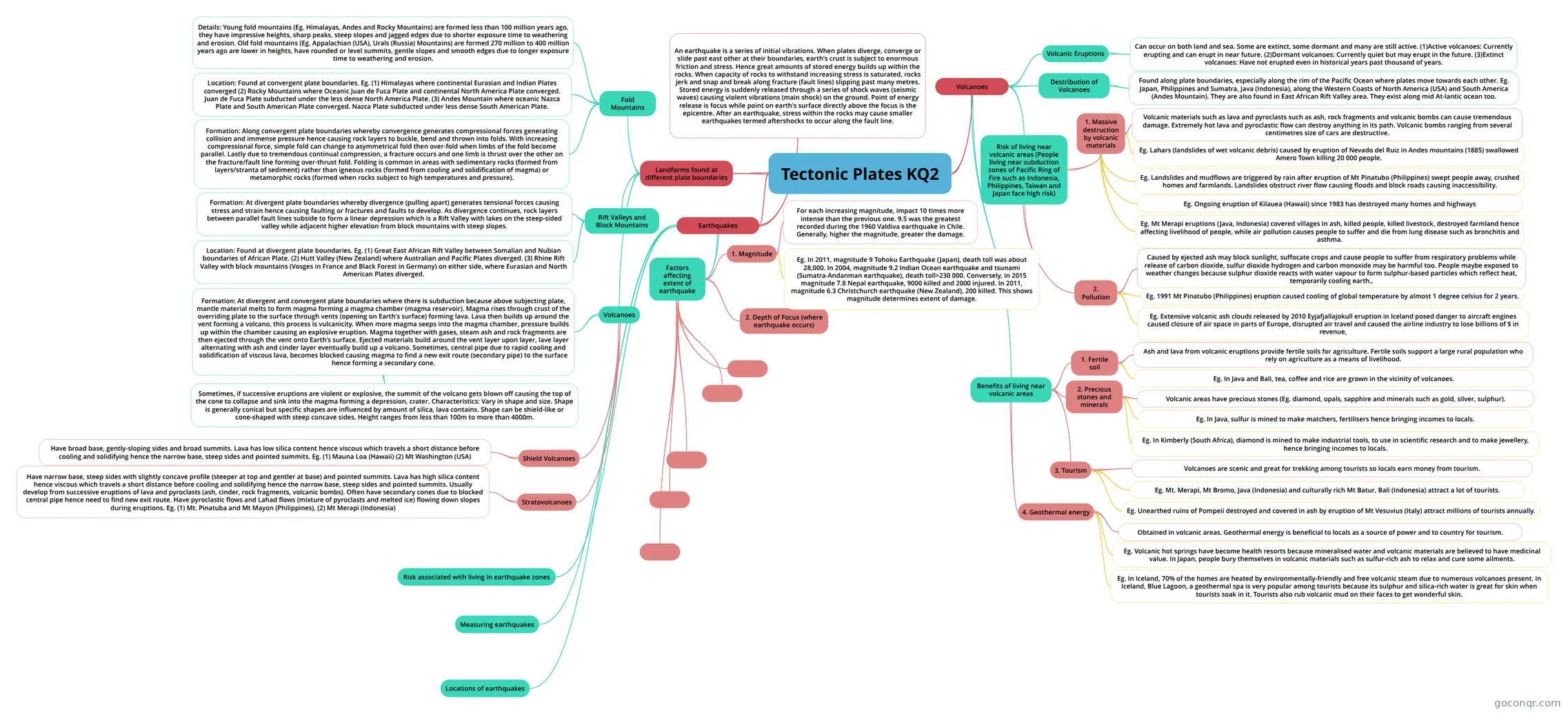
Mind map: Tectonic plates
Map content
Tectonic Plates KQ2
Landforms found at different plate boundaries
- Fold Mountains
- Formation: Along convergent plate boundaries whereby convergence generates compressional forces generating collision and immense pressure hence causing rock layers to buckle, bend and thrown into folds. With increasing compressional force, simple fold can change to asymmetrical fold then over-fold when limbs of the fold become parallel. Lastly due to tremendous continual compression, a fracture occurs and one limb is thrust over the other on the fracture/fault line forming over-thrust fold. Folding is common in areas with sedimentary rocks (formed from layers/stranta of sediment) rather than igneous rocks (formed from cooling and solidification of magma) or metamorphic rocks (formed when rocks subject to high temperatures and pressure).
- Location: Found at convergent plate boundaries. Eg. (1) Himalayas where continental Eurasian and Indian Plates converged (2) Rocky Mountains where Oceanic Juan de Fuca Plate and continental North America Plate converged. Juan de Fuca Plate subducted under the less dense North America Plate. (3) Andes Mountain where oceanic Nazca Plate and South American Plate converged. Nazca Plate subducted under less dense South American Plate.
- Details: Young fold mountains (Eg. Himalayas, Andes and Rocky Mountains) are formed less than 100 million years ago, they have impressive heights, sharp peaks, steep slopes and jagged edges due to shorter exposure time to weathering and erosion. Old fold mountains (Eg. Appalachian (USA), Urals (Russia) Mountains) are formed 270 million to 400 million years ago are lower in heights, have rounded or level summits, gentle slopes and smooth edges due to longer exposure time to weathering and erosion.
- Rift Valleys and Block Mountains
- Formation: At divergent plate boundaries whereby divergence (pulling apart) generates tensional forces causing stress and strain hence causing faulting or fractures and faults to develop. As divergence continues, rock layers between parallel fault lines subside to form a linear depression which is a Rift Valley with lakes on the steep-sided valley while adjacent higher elevation from block mountains with steep slopes.
- Location: Found at divergent plate boundaries. Eg. (1) Great East African Rift Valley between Somalian and Nubian boundaries of African Plate. (2) Hutt Valley (New Zealand) where Australian and Pacific Plates diverged. (3) Rhine Rift Valley with block mountains (Vosges in France and Black Forest in Germany) on either side, where Eurasian and North American Plates diverged.
- Volcanoes
- Shield Volcanoes
- Have broad base, gently-sloping sides and broad summits. Lava has low silica content hence viscous which travels a short distance before cooling and solidifying hence the narrow base, steep sides and pointed summits. Eg. (1) Mauna Loa (Hawaii) (2) Mt Washington (USA)
- Stratovolcanoes
- Have narrow base, steep sides with slightly concave profile (steeper at top and gentler at base) and pointed summits. Lava has high silica content hence viscous which travels a short distance before cooling and solidifying hence the narrow base, steep sides and pointed summits. Usually develop from successive eruptions of lava and pyroclasts (ash, cinder, rock fragments, volcanic bombs). Often have secondary cones due to blocked central pipe hence need to find new exit route. Have pyroclastic flows and Lahad flows (mixture of pyroclasts and melted ice) flowing down slopes during eruptions. Eg. (1) Mt. Pinatuba and Mt Mayon (Philippines), (2) Mt Merapi (Indonesia)
- Formation: At divergent and convergent plate boundaries where there is subduction because above subjecting plate, mantle material melts to form magma forming a magma chamber (magma reservoir). Magma rises through crust of the overriding plate to the surface through vents (opening on Earth's surface) forming lava. Lava then builds up around the vent forming a volcano, this process is vulcanicity. When more magma seeps into the magma chamber, pressure builds up within the chamber causing an explosive eruption. Magma together with gases, steam ash and rock fragments are then ejected through the vent onto Earth's surface. Ejected materials build around the vent layer upon layer, lave layer alternating with ash and cinder layer eventually build up a volcano. Sometimes, central pipe due to rapid cooling and solidification of viscous lava, becomes blocked causing magma to find a new exit route (secondary pipe) to the surface hence forming a secondary cone.
- Sometimes, if successive eruptions are violent or explosive, the summit of the volcano gets blown off causing the top of the cone to collapse and sink into the magma forming a depression, crater. Characteristics: Vary in shape and size. Shape is generally conical but specific shapes are influenced by amount of silica, lava contains. Shape can be shield-like or cone-shaped with steep concave sides. Height ranges from less than 100m to more than 4000m.
- Shield Volcanoes
- Fold Mountains
Volcanoes
- Destribution of Volcanoes
- Found along plate boundaries, especially along the rim of the Pacific Ocean where plates move towards each other. Eg. Japan, Philippines and Sumatra, Java (Indonesia), along the Western Coasts of North America (USA) and South America (Andes Mountain). They are also found in East African Rift Valley area. They exist along mid At-lantic ocean too.
- Volcanic Eruptions
- Can occur on both land and sea. Some are extinct, some dormant and many are still active. (1)Active volcanoes: Currently erupting and can erupt in near future. (2)Dormant volcanoes: Currently quiet but may erupt in the future. (3)Extinct volcanoes: Have not erupted even in historical years past thousand of years.
- Risk of living near volcanic areas (People living near subduction zones of Pacific Ring of Fire such as Indonesia, Philippines, Taiwan and Japan face high risk)
- 1. Massive destruction by volcanic materials
- Volcanic materials such as lava and pyroclasts such as ash, rock fragments and volcanic bombs can cause tremendous damage. Extremely hot lava and pyroclastic flow can destroy anything in its path. Volcanic bombs ranging from several centimetres size of cars are destructive.
- Eg. Lahars (landslides of wet volcanic debris) caused by eruption of Nevado del Ruiz in Andes mountains (1885) swallowed Amero Town killing 20 000 people.
- Eg. Landslides and mudflows are triggered by rain after eruption of Mt Pinatubo (Philippines) swept people away, crushed homes and farmlands. Landslides obstruct river flow causing floods and block roads causing inaccessibility.
- Eg. Ongoing eruption of Kilauea (Hawaii) since 1983 has destroyed many homes and highways
- Eg. Mt Merapi eruptions (Java, Indonesia) covered villages In ash, killed people, killed livestock, destroyed farmland hence affecting livelihood of people, while air pollution causes people to suffer and die from lung disease such as bronchitis and asthma.
- 2. Pollution
- Caused by ejected ash may block sunlight, suffocate crops and cause people to suffer from respiratory problems while release of carbon dioxide, sulfur dioxide hydrogen and carbon monoxide may be harmful too. People maybe exposed to weather changes because sulphur dioxide reacts with water vapour to form sulphur-based particles which reflect heat, temporarily cooling earth.,
- Eg. 1991 Mt Pinatubo (Philippines) eruption caused cooling of global temperature by almost 1 degree celsius for 2 years.
- Eg. Extensive volcanic ash clouds released by 2010 Eyjafjallajokull eruption in Iceland posed danger to aircraft engines caused closure of air space in parts of Europe, disrupted air travel and caused the airline industry to lose billions of $ in revenue,
- 1. Massive destruction by volcanic materials
- Benefits of living near volcanic areas
- 1. Fertile soil
- Ash and lava from volcanic eruptions provide fertile soils for agriculture. Fertile soils support a large rural population who rely on agriculture as a means of livelihood.
- Eg. In Java and Bali, tea, coffee and rice are grown in the vicinity of volcanoes.
- 2. Precious stones and minerals
- Volcanic areas have precious stones (Eg. diamond, opals, sapphire and minerals such as gold, silver, sulphur).
- Eg. In Java, sulfur is mined to make matchers, fertilisers hence bringing incomes to locals.
- Eg. In Kimberly (South Africa), diamond is mined to make industrial tools, to use in scientific research and to make jewellery, hence bringing incomes to locals.
- 3. Tourism
- Volcanoes are scenic and great for trekking among tourists so locals earn money from tourism.
- Eg. Mt. Merapi, Mt Bromo, Java (Indonesia) and culturally rich Mt Batur, Bali (Indonesia) attract a lot of tourists.
- Eg. Unearthed ruins of Pompeii destroyed and covered in ash by eruption of Mt Vesuvius (Italy) attract millions of tourists annually.
- 4. Geothermal energy
- Obtained in volcanic areas. Geothermal energy is beneficial to locals as a source of power and to country for tourism.
- Eg. In Iceland, 70% of the homes are heated by environmentally-friendly and free volcanic steam due to numerous volcanoes present. In Iceland, Blue Lagoon, a geothermal spa is very popular among tourists because its sulphur and silica-rich water is great for skin when tourists soak in it. Tourists also rub volcanic mud on their faces to get wonderful skin.
- Eg. Volcanic hot springs have become health resorts because mineralised water and volcanic materials are believed to have medicinal value. In Japan, people bury themselves in volcanic materials such as sulfur-rich ash to relax and cure some ailments.
- 1. Fertile soil
- Destribution of Volcanoes
Earthquakes
- Factors affecting extent of earthquake
- 1. Magnitude
- For each increasing magnitude, impact 10 times more intense than the previous one. 9.5 was the greatest recorded during the 1960 Valdiva earthquake in Chile. Generally, higher the magnitude, greater the damage.
- Eg. In 2011, magnitude 9 Tohoku Earthquake (Japan), death toll was about 28,000. In 2004, magnitude 9.2 Indian Ocean earthquake and tsunami (Sumatra-Andanman earthquake), death toll>230 000. Conversely, in 2015 magnitude 7.8 Nepal earthquake, 9000 killed and 2000 injured. In 2011, magnitude 6.3 Christchurch earthquake (New Zealand), 200 killed. This shows magnitude determines extent of damage.
- 2. Depth of Focus (where earthquake occurs)
- 1. Magnitude
- An earthquake is a series of initial vibrations. When plates diverge, converge or slide past east other at their boundaries, earth's crust is subject to enormous friction and stress. Hence great amounts of stored energy builds up within the rocks. When capacity of rocks to withstand increasing stress is saturated, rocks jerk and snap and break along fracture (fault lines) slipping past many metres. Stored energy is suddenly released through a series of shock waves (seismic waves) causing violent vibrations (main shock) on the ground. Point of energy release is focus while point on earth's surface directly above the focus is the epicentre. After an earthquake, stress within the rocks may cause smaller earthquakes termed aftershocks to occur along the fault line.
- Risk associated with living in earthquake zones
- Measuring earthquakes
- Locations of earthquakes
- Factors affecting extent of earthquake
Information
- Description
- Mind Map on Tectonic Plates KQ2, created by Michelle Lim on 10/09/2018.
- Created by
- Michelle Lim
- Views
- 0
- Rating