
Plate Tectonics
157 resources created by 134 users
This Plate Tectonics page on GoConqr gathers community-made quizzes, mind maps, flashcards, notes and slide sets on the restless Earth, from plate boundaries and the structure of the Earth to fold mountains, earthquakes and volcano case studies. It's built for school students revising for GCSE Geography and teachers after ready-made material. There are over 600 resources here, including more than 30 quizzes and over 400 mind maps, almost all at secondary level. Pick a topic, try a quiz to find your gaps, then make your own revision sets.
Top Plate Tectonics resources
-
38 cardsTectonic landscape Distribution of earthquakes and volcanoes
-
52 cardsRestless earth flash cards - geography 4 parts of the earth ?
-
Mind map Geography Restless Earth Mind map about the restless earth unit for gcse geography
-
17 questionsAQA Geography Tectonics Quiz What are the characteristics of the continental crust?
-
Mind map Restless Earth GCSE Geography AQA A Specification Unit 1A The Restless Earth
-
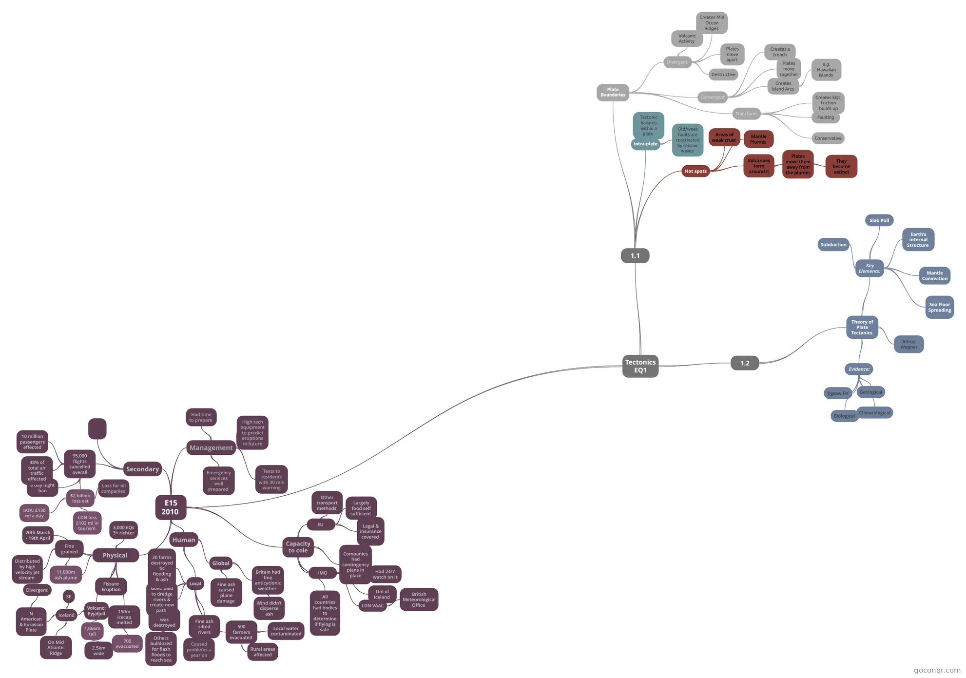 Mind map Tectonics EQ1 Edexcel Geography AS
-
10 questionsChapter 13 test 2 What are waves of energy that travel through Earth called?
-
Mind map Restless Earth Mind Map of Edexcel Physical Geography Topic 1
Quizzes
See all 13 quizzes-
17 questionsAQA Geography Tectonics Quiz What are the characteristics of the continental crust?
-
10 questionsChapter 13 test 2 What are waves of energy that travel through Earth called?
-
8 questionsAQA GCSE Geography A - Unit 1 - 1.1 - The Restless Earth What is the outer layer of the earth called?
-
30 questionsGeography Quiz Plate Tectonics GW2 Which of the following is true about a fold in geographical term. May choose more than one.
-
19 questionsGeography fold mountains case study Quiz on Geography food mountains case study, created by emilyb6778 on 31/03/2017.
-
10 questionsGeography Quiz on Plate Tectonics GW1 Convergent plate boundary is also known as destructive plate boundary
-
15 questionsAQA geography gcse- restless earth case studies How many people died in the Haiti earthquake?
-
10 questionsRestless Earth Quiz Continental crust is thicker and less dense than oceanic crust? Is it true or false?
Mind maps
See all 70 mind maps-
Geography Restless Earth Mind map about the restless earth unit for gcse geography
-
Restless Earth GCSE Geography AQA A Specification Unit 1A The Restless Earth
-
Tectonics EQ1 Edexcel Geography AS
-
Restless Earth Mind Map of Edexcel Physical Geography Topic 1
-
Plate Margins
-
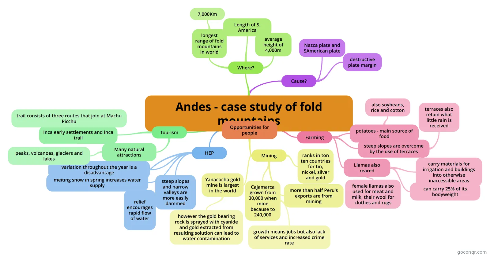 Andes - case study of fold mountains
-
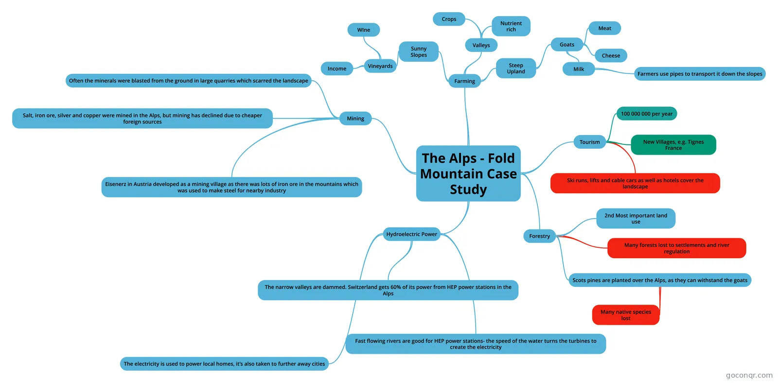 The Alps - Fold Mountain Case Study Information taken from a note by helen_rebecca
-
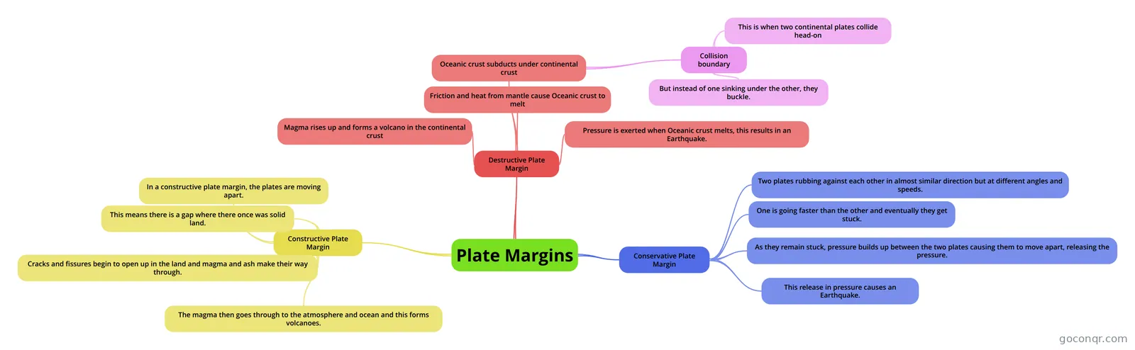 Plate Margins
Flashcards
See all 55 flashcards-
38 cardsTectonic landscape Distribution of earthquakes and volcanoes
-
52 cardsRestless earth flash cards - geography 4 parts of the earth ?
-
14 cardsGCSE Geography restless earth Mount Pinatubo, Philippines
-
5 cardsNyiragongo case study 2002 Nyiragongo Eruption Case Study
-
60 cardsGeography GCSE unit 1a-the restless earth what is at the centre of the earth?
-
43 cardsTectonics Why are some areas at greater risk from tectonic hazards than others?
-
31 cardsGeog - Tectonic Hazards - Gateway 2 Phenomena/landforms found at plate boundaries and how they are formed
-
21 cardsGeography IGNEOUS ROCK. . . Made of molten lava/magma (volcanic) Formed under the surface (intrusive) Magma created &...
Notes
See all 16 notes-
Geography - The Restless Earth - Supervolcanoe - Yellowstone CASE STUDY Yellowstone Supervolcano CASE STUDY Background · Yellowstone National Park is located in the North West of the USA in the state of Wyoming, although it extends slightly into Montana and Idaho. · It was the first Natio...
-
Restless Earth Notes Structure of the Earth The crust is a thin layer of solid rock floating on the semi molten mantle.It is made of sections called plates which an be continental or oceanic Continental plates are older, thicker and...
-
The Geography Of Earthquakes Earthquakes are vibrations or tremors in the earth's crust that are cause by the sudden release of energy along a fault line.The seismic waves or tremors are known as shocks. The largest shock is called the main shock...
-
Case Study for the Alps Geography Unit 1A - Fold Mountain Case Study Here is a bit of a fun video of images of the beautiful land of the Alps... sorry about the crazy music. Although, I must say I like his taste in music! Location - Cen...
-
Alps, Human uses of fold mountains case study Human uses of fold mountains (The Alps Case Study) Farming · The steep upland areas are used to farm goats, to produce milk, meat and cheese · &n...
-
Geography - The Restless Earth - Volcanoe - Mt St Helens CASE STUDY Mt St Helen CASE STUDY Background · Mt St Helens is one of the 5 volcanoes in the Cascade Range in Washington State, USA. · Like these others it had been dormant for many years · In March 1980 there were signs of an i...
-
Geography - The Restless Earth - Tsunami - Japan CASE STUDY Japan 2011 Tsunami CASE STUDY Causes · The Pacific plate sub-ducted underneath the Eurasian Plate which caused a large build up of pressure. · This large amount of pressure eventually released, causing the Eurasian pl...
-
Geography - The Restless Earth - Earthquake in a LEDC - Haiti CASE STUDY Haiti Earthquake MEDC CASE STUDY Background · Haiti is a small island located in the Caribbean, South East of the USA and the East of Cuba. · Its capital city is Port-au-Prince · 72% of the population live on less tha...
Slides
More Geography topics
About Plate Tectonics
GoConqr OriginalWhat the unit covers
This unit follows the restless Earth topic that many GCSE courses use. The mind maps are the largest group. Tectonics EQ1 sorts plate boundaries into divergent, convergent and transform, and links each to earthquakes, mid ocean ridges and friction building up. The mind map Restless Earth covers the structure of the Earth, from the thin crust to the upper mantle and the lithosphere.
Case studies to know
Case studies are a big part of the list. You will find the Yellowstone supervolcano note, a note on Mt St Helens, and a Nyiragongo case study 2002 flashcard deck. For earthquakes there are notes on Haiti and a note on the Sichuan earthquake in China, plus a Kashmir Earthquake slide set. A note on the Tsunami in Japan is here too.
Fold mountains have their own cluster. The Alps appear as a note, a quiz and the mind map The Alps - Fold Mountain Case Study, which covers farming, mining, tourism, hydroelectric power and forestry. The Andes mind map explains the Nazca and South American plates.
Where to start
- Open the mind map Tectonics EQ1 to get the three boundary types clear.
- Work through the flashcard deck Tectonic landscape to learn key terms, hotspots and the distribution of earthquakes and volcanoes.
- Take the AQA Geography Tectonics Quiz, which tests crust types and conservative boundaries.
- Move on to the case studies, one hazard at a time.
Using quizzes and maps together
Read a map first, then close it and take a quiz on the same idea. If a question catches you out, go back to the matching map branch or flashcard and try again. Teachers can set a map as a starter and a quiz as a check at the end of a lesson.
Where it sits
This unit belongs to the strand Physical Landscapes and Earth Processes in Geography. The resources mention GCSE Geography, AQA GCSE Geography and A-level Geography, so check the wording against your own course. When you are ready, choose a case study and build a mind map or flashcard set of your own.
Frequently asked questions
Which resource should I open first?
Start with the mind map Tectonics EQ1. It sets out divergent, convergent and transform boundaries and what each one creates. Then try the flashcard deck Tectonic landscape for key terms, and the AQA Geography Tectonics Quiz to see what has stuck.
What case studies are included?
The list includes Yellowstone supervolcano, Mt St Helens, Nyiragongo in 2002, the Haiti earthquake, the Sichuan earthquake in China, the Kashmir earthquake and the Japan tsunami. For fold mountains there are several resources on the Alps and a mind map on the Andes.
Which exams do these resources suit?
The resources mention GCSE Geography, AQA GCSE Geography and A-level Geography. Almost all are at secondary level. Course wording and case studies differ between specifications, so check the resources against what your teacher or exam board expects.
Are the resources free to use?
Yes. Every resource on this page is free to open, study and take, with no account needed. They were made by GoConqr users rather than by GoConqr, so it is worth comparing a few on the same topic. A free account saves your quiz scores and lets you make your own.
What do the mind maps cover?
They cover plate boundaries, the structure of the Earth, earthquakes, volcanoes, folding and faulting, and why people live in areas of tectonic activity. Several are case study maps, such as the Alps, which looks at farming, tourism and hydroelectric power.
How can teachers use this page?
Teachers can pick a mind map to introduce a topic, use a flashcard deck for a quick recap, and set a quiz such as Geography: Fold Mountains - The Alps as a check. Slide sets like Kashmir Earthquake can support case study lessons.