
Mind map
Water on the land
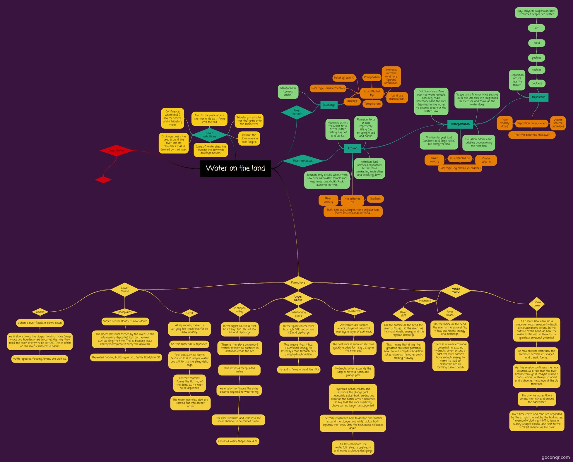
Mind map: Water on the land
Map content
Water on the land
Formations
- Upper course
- V-shaped valley
- In the upper course a river has a high GPE thus a low KE and discharge
- There is therefore downward vertical erosion as particles in saltation erode the bed
- This leaves a steep sided valley
- As erosion continues, the sides become exposed to weathering
- The rock weakens and falls into the river channel to be carried away
- Leaves a valley shaped like a 'V'.
- The rock weakens and falls into the river channel to be carried away
- As erosion continues, the sides become exposed to weathering
- This leaves a steep sided valley
- There is therefore downward vertical erosion as particles in saltation erode the bed
- In the upper course a river has a high GPE thus a low KE and discharge
- Interlocking spurs
- In the upper course river has high GPE and so low KE and discharge
- This means that it has insufficient energy to laterally erode through hills using hydraulic action
- Instead it flows around the hills
- This means that it has insufficient energy to laterally erode through hills using hydraulic action
- In the upper course river has high GPE and so low KE and discharge
- Waterfall
- Waterfalls are formed where a layer of hard rock overlays a layer of soft rock.
- The soft rock is more easily thus quickly eroded, forming a step in the river bed.
- Hydraulic action expands the step to form a notch and plunge pool.
- Hydraulic action erodes and expands the plunge pool, meanwhile splashback erodes and expands the notch, until it becomes so big that the rock overhang above can no longer be supported.
- The rock fragments help to abrade and further expand the plunge pool, whilst splashback expands the notch, until the rock above collapses again.
- As this continues, the waterfall retreats upstream and leaves a steep-sided groge
- The rock fragments help to abrade and further expand the plunge pool, whilst splashback expands the notch, until the rock above collapses again.
- Hydraulic action erodes and expands the plunge pool, meanwhile splashback erodes and expands the notch, until it becomes so big that the rock overhang above can no longer be supported.
- Hydraulic action expands the step to form a notch and plunge pool.
- The soft rock is more easily thus quickly eroded, forming a step in the river bed.
- Waterfalls are formed where a layer of hard rock overlays a layer of soft rock.
- V-shaped valley
- Middle course
- Meanders
- River cliff
- On the outside of the bend the river is fastest so the river has the most kinetic energy and the highest discharge
- This means that it has the greatest erosional potential here, so lots of hydraulic action takes place on the outer bank, eroding it away.
- On the outside of the bend the river is fastest so the river has the most kinetic energy and the highest discharge
- River beach
- On the inside of the bend the river is the slowest. So, it has low kinetic energy and discharge.
- There is a lower erosional potential here, so no hydraulic action occurs. In fact, the river doesn't have enough energy to carry its load so deposition occurs, forming a river beach.
- On the inside of the bend the river is the slowest. So, it has low kinetic energy and discharge.
- River cliff
- Oxbow Lake
- As a river flows around a meander, most erosion (hydraulic action/abrasion) occurs on the outside of the bend, as here the water is fastest so there is the greatest erosional potential.
- As this erosion continues, the meander becomes S-shaped and a neck forms.
- As this erosion continues the neck becomes so small that the river breaks through it (maybe during a flood), leaving a straight channel and a channel the shape of the old meander.
- For a while water flows across the neck and around the backwater.
- Over time earth and mud are deposited by the stright channel, by the backwater, eventually blocking it off to leave a kidney-shaped oxbow lake next to the straight channel of the river.
- For a while water flows across the neck and around the backwater.
- As this erosion continues the neck becomes so small that the river breaks through it (maybe during a flood), leaving a straight channel and a channel the shape of the old meander.
- As this erosion continues, the meander becomes S-shaped and a neck forms.
- As a river flows around a meander, most erosion (hydraulic action/abrasion) occurs on the outside of the bend, as here the water is fastest so there is the greatest erosional potential.
- Meanders
- Lower course
- Delta
- At its mouth, a river is carrying too much load for its slow velocity.
- So, this material is deposited.
- Fine load such as clay is deposited last in deeper water and silt forms the steep delta edge.
- Coarser material forms the flat top of the delta. as it's first to be deposited
- The finest particles, clay, are carried out into deeper water.
- Coarser material forms the flat top of the delta. as it's first to be deposited
- Fine load such as clay is deposited last in deeper water and silt forms the steep delta edge.
- So, this material is deposited.
- At its mouth, a river is carrying too much load for its slow velocity.
- Floodplains
- When a river floods, it slows down.
- The finest material carried by the river (i.e. the alluvium) is deposited last on the area surrounding the river. This is because least energy is required to carry the alluvium.
- Repeated flooding builds up a rich, fertile floodplain (?)
- The finest material carried by the river (i.e. the alluvium) is deposited last on the area surrounding the river. This is because least energy is required to carry the alluvium.
- When a river floods, it slows down.
- Levees
- When a river floods, it slows down.
- As it slows down, the biggest load particles (large rocks and boulders) are deposited first (as they need the most energy to be carried). This is often on the river's immediate banks.
- With repeated flooding, levees are built up.
- As it slows down, the biggest load particles (large rocks and boulders) are deposited first (as they need the most energy to be carried). This is often on the river's immediate banks.
- When a river floods, it slows down.
- Delta
- Upper course
River processes
- Erosion
- Transportation
- Deposition
- Deposition occurs when:
- River velocity drops
- The river becomes shallower
- Water volume decreases
- boulders
- cobbles
- pebbles
- sand
- silt
- clay: stays in suspension until it reaches deeper sea-water
- silt
- sand
- pebbles
- cobbles
- Deposition occurs near the mouth
- Deposition occurs when:
- Traction: largest load (boulders and large rocks) roll along the bed.
- Saltation: Stones and pebbles bounce along the river bed.
- Solution: rivers flow over rainwater-soluble rock (e.g. chalk, limestone) and the rock dissolves in the water to become a part of the water flow.
- Suspension: fine particles such as sand, silt and clay are suspended in the river and move as the water does.
- It is affected by:
- Rock type (e.g. shales vs. granite)
- River velocity
- Water volume
- Deposition
- Hydarulic action: the sheer force of the water hitting the bed and banks.
- Abrasion: force of load repeatedly hitting (and scraping?) bed and banks.
- Attrition: load particles repeatedly hitting thus weakening each other and breaking down..
- Solution: only occurs when rivers flow over rainwater-soluble rock (e.g. limestone, chalk). Rock dissolves in river.
- It is affected by:
- Gradient
- River velocity
- Rock type (e.g. sharper, more angular load increases erosional potential)
- Transportation
- Erosion
Case studies
River features
- Discharge
- Measured in cumecs (m3/s)
- It is affected by:
- RRPPLT
- Relief (gradient)
- Rock type ((im)permeable)
- Precipitation
- Previous weather conditions (ground saturation)
- Land use (rural/urban)
- Temperature
- Discharge
River definitions
- Source: the place where a river begins
- Tributary: a smaller river that joins onto the main river
- Mouth: the place where the river ends as it flows into the sea
- Confluence: where and 2 rivers/ a river and a tributary meet
- Drainage basin: the area around the river and its tributaries that is drained by that river.
- (Line of) watershed: the dividing line between drainage basins)
Information
- Description
- GCSE Geography Mind Map on Water on the land, created by Vimo Zatov on 20/09/2016.
- Created by
- Vimo Zatov
- Views
- 0
- Rating