
Mind map
Tropical climates (Monsoons)
Map content
Tropical climates (Monsoons)
Characteristics of a monsoon
- High rainfall - About 3000m a year, mostly falling in the wet season (summer)
- Winds change direction with the seasons - In the wet season (summer) the winds blow towards the land, in the dry season (winter) the winds blow towards the sea.
- Hot temperatures - All year round hot temperatures (between 18° and 30°) because of the latitude therefore the sun will always be high in the sky (more insolation).
Seasonal changes
- Wet season (July) - Due to the angle of rotation the sun is over the tropic of cancer which pulls the ITCZ to the north of the equator. Here is an area of low pressure (due to the convectional air flow) so it brings heavy rainfall to the tropical monsoon regions. The winds are forced to travel from the ocean (high pressure) to the land (low pressure) carrying warm surface winds (oceans retain more heat) and higher temperatures.
- Dry season (January) - Due to the angle of rotation the sun is over the tropic of capricorn which pulls the ITCZ to the south of the equator. The low pressure zone is over the ocean (where the rainfall occurs) therefore the monsoon regions stay drier as they are under a high pressure zone. The winds are forced to travel from the land (high pressure) to the ocean (low pressure) resulting in cooler winds as the land cools down faster. These bring lower temperatures.
Tropical revolving storms
- Conditions needed for them to form
- Oceanic location with sea temperatures of over 27° to at least 50m below the surface (provides a continuous source of heat to maintain rising air currents (evaporation)
- An ocean depth of at least 70m (provides continuous latent heat (energy released when gas turns to liquid(condensation)), this drives the system)
- A location at least 5° North or South from the equator (only here will the Coriolis force bring the maximum rotation of air, nearer the equator it wouldn't be strong enough).
- Low level convergence of air in the lower atmospheric circulation system (trade winds) as the winds need to converge near a point of low pressure (caused by a rising of air (evaporation))
- Usually occur when the inter-tropical convergence zone (ITCZ) has migrated to it's most northernly point (allows air to come together at low points)
- Tropical revolving storms: Intense low pressure weather systems that develop in the tropics. These are violent storms that can be between 200-700km in diameter and bring strong winds and torrential rain.
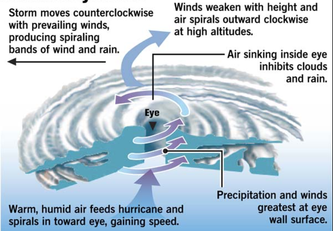
- Formation of a tropical revolving storm - 1. When the ocean reaches 27° or higher it causes surface heating (evaporation) which creates an area of low pressure. 2. When the warm moist air condenses (cools when rises) it forms large cumulonimbus clouds and with the latent heat released increases wind speed. 3. Cold air rushes in to fill the void left by the rising warm air (constant uplift). 4. If the existing trade winds (caused by the Coriolis force) converge near the centre of this low-pressure area is produces a rotating system (tropical depression) which cause the air mass to spiral with great force. 4. As the storm builds it begins to move anti-clockwise, away from the equator, being fueled by a steady flow of warm, moist air and increasing heat energy caused by latent heat. 5. As the storm matures a central eye is developed. 6. Tropical storms typically loose their strength when moving overland as their warm, moist air supply is cut off.
- Central eye - An area 10-15km wide in the centre of the storm. This area is created through air descending (air becomes colder and therefore denser) and creates calm conditions, clear skies and warm temperatures. Around the eye (the eye wall) is the most destructive with the highest wind speeds and severe thunderstorms
- Once generated at the equator they tend to move westwards, depending on where they occur determines the name they'll be given: Caribbean sea/Gulf of Mexico (Hurricanes), the Bay of Bengal (Cyclones), southeast Asia (Typhoons), Australia (Willy-willies)
- Tropical revolving storms are measured by the Saffir-Simpson scale, which has 5 levels based upon wind speed, central pressure, storm surge and potential damage.
- Impacts
- Environmental - Strong winds and storm surges erode beaches and coastal habitats are damaged ie. coral reefs. The environment get polluted due to the salt water, chemicals spilled from factories and oil spills caused by the storm.
- Economic - Infrastructure (roads, bridges, railways, buildings, ports/airports) is damaged/destroyed which costs money to rebuild. Business premises are damaged/destroyed so trading is not possible. Agricultural land is damaged so commercial farming suffers.
- Social - People are left homeless, electricity supplies are cut off (cables/pylons damaged), People may drown/be injured/killed by debris carried by the storm or floodwaters, diseases can be spread easily (lack of clean water/sanitation), shortage of food as crops are damaged and livestock are killed (usually poorer countries), aid/emergency vehicles struggle to reach affected areas as the roads are damaged.
- Responses
- Evacuation - Scientists use radars, satellites and aircraft to track storms and this gives them data to predict where and when they'll hit land and the predicted path(entered into a computer program). This gives time for people to evacuate and protect their homes/businesses ie. boarding windows. Evacuation can be an effective response however if the calculations are wrong then it'll waste a lot of time and money.
- Planning and education - 1. Future developments can be planned to avoid the areas most at risk (ie.by the coast). 2. Emergency services can be trained so they're prepared for an event like this. 3. Evacuation routes can be generated in order to get people away from the storms quickly. 4. Governments and other organisations can educate people in how to prepare for an event like this (ie. stockpiling food/water) and how to evaacuate. All cost effective measures.
- In florida - evacuation routes are signposted clearly along the coast.
- The FEMA (Federal Emergency Management Agency) train emergency personnel to deal with disasters such as hurricanes and floods (USA)
- Building techniques - Buildings can be built to withstand tropical storms ie. using reinforced concrete or fixing roofs securely. They could also be put on stilts to be safe from flooding (Along USA's Gulf coast this is the case). Flood defences could be built along rivers/coasts ie. levees to withstand storm surges and flooding. Effective but doesn't guarantee damage prevention.
- Flood defences (levees) brokes in New Orleans during hurricane Katrina (only built to withstand category 3 hurricane), flooding the city
- Aid - Governments/organisations can be effective by providing and distributing aid, however there are often problems with getting it to the areas suffering as the roads are damaged or due to political reasons.
- Impacts
- Conditions needed for them to form
Monsoon climates are found 5 and 20° North and south of the equator (between the ITCZ and the zone of subtropical high pressure(end of the Hadley cell).
- ITCZ (Inter-tropical convergence zone) : Low pressure zone located at the Equator between both Hadley cells. The sun warms the Earth causing air to rise, resulting in convection currents. Rising air creates low pressure, heavy rainfall and clouds can be created due to the rising water vapour condensing (thunderstorms likely). In the summer (June) - sun is located above the tropic of Cancer so pulls the ITCZ north of the equator. In the winter (December) - the sun is over the tropic of Capricorn so pulls the ITCZ south of the equator.
Images and files in the map
Information
- Description
- A level Geography (Weather & Climate) Mind Map on Tropical climates (Monsoons), created by Natalie Bond on 17/05/2017.
- Created by
- Natalie Bond
- Views
- 1
- Rating