
Mind map
Rivers
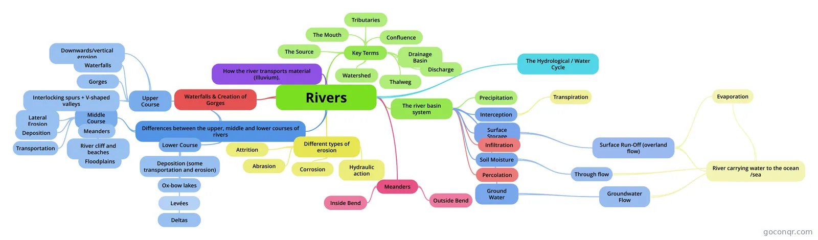
Mind map: Rivers
Map content
Rivers
The Hydrological / Water Cycle
- The continuous transfer of water from the ocean to the atmosphere, onto the land and falls back into the ocean.
Differences between the upper, middle and lower courses of rivers
- Upper Course
- Downwards/vertical erosion
- Waterfalls
- Gorges
- Interlocking spurs + V-shaped valleys
- Middle Course
- Lateral Erosion
- Deposition
- Transportation
- 1. In solution: dissolved rock 2. In suspension 3. In saltation: Bouncing along the river bed 4. In traction: Rolled along the bed
- Meanders
- River cliff and beaches
- Floodplains
- Lower Course
- Deposition (some transportation and erosion)
- Levées
- Raised banks on either side of the river. This is caused by deposition of the rivers load when the river floods. The heavier load is deposited first.
- Levées
- Ox-bow lakes
- Remains of meander loops that have been cut off by meander migration.
- Deltas
- Deposited silt at the end of the river.
- Deposition (some transportation and erosion)
- Upper Course
Different types of erosion
- Attrition
- Material (the load) carried by the river bump into each other and so are smoothed and broken down into smaller pieces.
- Abrasion
- The bed and banks are worn down by the load.
- Hydraulic action
- The sheer force of the water against the bed and banks.
- Corrosion
- The chemical action of river water. The acids in the water slowly dissolve the bed and the banks.
- Attrition
How the river transports material (Illuvium).
Waterfalls & Creation of Gorges
Meanders
- Usually have an asymmetrical cross section.
- Inside Bend
- River Beach Lower Velocity More Deposition Shallower Water
- Outside Bend
- River Cliff Higher Velocity More abrasion Deeper Water
Key Terms
- The Source
- The point at which the river begins.
- The Mouth
- The point at which the river meets the sea.
- Tributaries
- Small streams or channels the feed into the river.
- Confluence
- The point at which two rivers meet.
- Drainage Basin
- An area of land drained by a river and it's tributaries.
- Watershed
- A line separating two drainage basins.
- Discharge
- The velocity of a volume of water in a paricular area
- Thalweg
- The Source
The river basin system
- Green = Input Lilac = Storage Red = Flow Yellow = Output
- Interception
- Transpiration
- Surface Storage
- Surface Run-Off (overland flow)
- River carrying water to the ocean /sea
- Evaporation
- River carrying water to the ocean /sea
- Surface Run-Off (overland flow)
- Infiltration
- Soil Moisture
- Through flow
- Through flow
- Percolation
- Precipitation
- Ground Water
- Groundwater Flow
- Groundwater Flow
Information
- Description
- igcse Archive Mind Map on Rivers, created by Zain Mirza on 19/05/2014.
- Created by
- Zain Mirza
- Views
- 26
- Rating