
Mind map
Canadian Geography
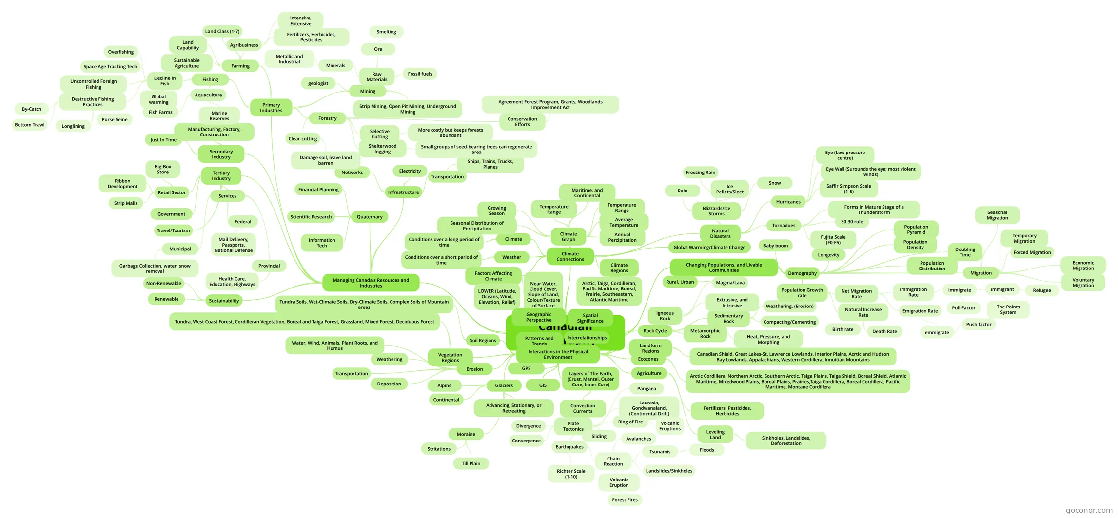
Mind map: Canadian geography
Map content
Canadian Geography
Interactions in the Physical Environment
- Layers of The Earth, (Crust, Mantel, Outer Core, Inner Core)
- Convection Currents
- Plate Tectonics
- Earthquakes
- Richter Scale (1-10)
- Chain Reaction
- Tsunamis
- Floods
- Landslides/Sinkholes
- Avalanches
- Volcanic Eruption
- Forest Fires
- Tsunamis
- Divergence
- Convergence
- Sliding
- Pangaea
- Laurasia, Gondwanaland, (Continental Drift)
- Ring of Fire
- Volcanic Eruptions
- Earthquakes
- Plate Tectonics
- Convection Currents
- Erosion
- Weathering
- Transportation
- Deposition
- Water, Wind, Animals, Plant Roots, and Humus
- Glaciers
- Alpine
- Continental
- Advancing, Stationary, or Retreating
- Moraine
- Stritations
- Till Plain
- Landform Regions
- Canadian Shield, Great Lakes-St. Lawrence Lowlands, Interior Plains, Acrtic and Hudson Bay Lowlands, Appalachians, Western Cordillera, Innuitian Mountains
- Soil Regions
- Tundra Soils, Wet-Climate Soils, Dry-Climate Soils, Complex Soils of Mountain areas
- Vegetation Regions
- Tundra, West Coast Forest, Cordilleran Vegetation, Boreal and Taiga Forest, Grassland, Mixed Forest, Deciduous Forest
- Ecozones
- Arctic Cordillera, Northern Arctic, Southern Arctic, Taiga Plains, Taiga Shield, Boreal Shield, Atlantic Maritime, Mixedwood Plains, Boreal Plains, Prairies,Taiga Cordillera, Boreal Cordillera, Pacific Maritime, Montane Cordillera
- Rock Cycle
- Igneous Rock
- Magma/Lava
- Extrusive, and Intrusive
- Sedimentary Rock
- Weathering, (Erosion)
- Compacting/Cementing
- Metamorphic Rock
- Heat, Pressure, and Morphing
- Igneous Rock
- GPS
- GIS
- Agriculture
- Leveling Land
- Sinkholes, Landslides, Deforestation
- Fertilizers, Pesticides, Herbicides
- Leveling Land
- Layers of The Earth, (Crust, Mantel, Outer Core, Inner Core)
Climate Connections
- Climate
- Conditions over a long period of time
- Weather
- Conditions over a short period of time
- Climate Graph
- Temperature Range
- Annual Percipitation
- Average Temperature
- Temperature Range
- Growing Season
- Maritime, and Continental
- Seasonal Distribution of Percipitation
- Natural Disasters
- Blizzards/Ice Storms
- Rain
- Freezing Rain
- Ice Pellets/Sleet
- Snow
- Hurricanes
- Saffir Simpson Scale (1-5)
- Eye (Low pressure centre)
- Eye Wall (Surounds the eye; most violent winds)
- Tornadoes
- Forms in Mature Stage of a Thunderstorm
- 30-30 rule
- Fujita Scale (F0-F5)
- Blizzards/Ice Storms
- Global Warming/Climate Change
- Factors Affecting Climate
- LOWER (Latitude, Oceans, Wind, Elevation, Relief)
- Near Water, Cloud Cover, Slope of Land, Colour/Texture of Surface
- Climate Regions
- Arctic, Taiga, Cordilleran, Pacific Maritime, Boreal, Prairie, Southeastern, Atlantic Maritime
- Climate
Managing Canada's Resources and Industries
- Secondary Industry
- Just In Time
- Manufacturing, Factory, Construction
- Tertiary Industry
- Retail Sector
- Ribbon Development
- Strip Malls
- Big-Box Store
- Government
- Travel/Tourism
- Services
- Federal
- Mail Delivery, Passports, National Defense
- Provincial
- Health Care, Education, Highways
- Municipal
- Garbage Collection, water, snow removal
- Federal
- Retail Sector
- Quaternary
- Information Tech
- Scientific Research
- Financial Planning
- Sustainability
- Renewable
- Non-Renewable
- Infrastructure
- Transportation
- Ships, Trains, Trucks, Planes
- Electricity
- Networks
- Transportation
- Primary Industries
- Fishing
- Decline in Fish
- Space Age Tracking Tech
- Uncontrolled Foreign Fishing
- Destructive Fishing Practices
- By-Catch
- Bottom Trawl
- Longlining
- Purse Seine
- Overfishing
- Global warming
- Aquaculture
- Fish Farms
- Marine Reserves
- Decline in Fish
- Farming
- Land Capability
- Agribusiness
- Fertilizers, Herbicides, Pesticides
- Intensive, Extensive
- Sustainable Agriculture
- Land Class (1-7)
- Mining
- Raw Materials
- Ore
- Smelting
- Fossil fuels
- Minerals
- Metallic and Industrial
- Ore
- Strip Mining, Open Pit Mining, Underground Mining
- geologist
- Raw Materials
- Forestry
- Clear-cutting
- Damage soil, leave land barren
- Selective Cutting
- More costly but keeps forests abundant
- Shelterwood logging
- Small groups of seed-bearing trees can regenerate area
- Conservation Efforts
- Agreement Forest Program, Grants, Woodlands Improvement Act
- Clear-cutting
- Fishing
- Secondary Industry
Changing Populations, and Livable Communities
- Demography
- Population Growth rate
- Natural Increase Rate
- Birth rate
- Death Rate
- Net Migration Rate
- Immigration Rate
- immigrate
- immigrant
- Refugee
- The Points System
- Pull Factor
- immigrant
- immigrate
- Emigration Rate
- emmigrate
- Push factor
- emmigrate
- Immigration Rate
- Natural Increase Rate
- Longevity
- Baby boom
- Doubling Time
- Population Pyramid
- Population Density
- Population Distribution
- Migration
- Forced Migration
- Economic Migration
- Seasonal Migration
- Voluntary Migration
- Temporary Migration
- Population Growth rate
- Rural, Urban
- Demography
Geographic Perspective
Interrelationships
Patterns and Trends
Spatial Significance
Information
- Description
- Mind Map on Canadian Geography, created by coraajna on 12/06/2014.
- Created by
- coraajna
- Views
- 38
- Rating