
Notes
Geography 2.2 Rivers
Content of the notes (3)
Page 1
Rivers
All rivers start at the highest point in an area
As the river flows downstream, it gains more water from other streams, rivers, springs, added rainfall, and other water sources.
A river is freshwater flowing across the surface of the land, usually to the sea.
Rivers flow in channels.
The bottom of the channel is called the bed.
The sides of the channel are called the banks.
Every river has a source; a place where the river begins its journey.
The source of a river is usually found in high places such as hills or mountains.
A river can have more than one source.
The beginning of a river is called its headwaters.
Different types of sources
Springs
Some rivers begin where a natural spring releases water from underground.
Rainfall and melting snow
Some rivers begin in mountains or hills, where rain water or snow melt collects and forms small channels.
At first, the channels are small and are called rills.
As more water enters the channels they grow forming gullies (larger channels).
The streams in the gullies eventually become big enough to form a river.
Lakes
The source of some rivers is a lake. The source of the River Nile is Lake Victoria, in Burundi.
Bogs
In some places, rain water can’t sink into the ground as the ground is too wet already. The water forms a bog.
The water flows out of the bog to form lakes and streams.
Channel
The shape of a river channel depends on...
How much water has been flowing in it.
For how long,
Over what kinds of soil or rock,
And through what vegetation.
There are many different kinds of river channels...
some are wide and constantly changing,
some crisscross like a braid, and
others stay in one main channel between steep banks.
The bends in a river called “meanders” which are caused by the water taking away soil on the outside of a river bend and laying it down the inside of a river bend over time.
Each kind of river channel has unique benefits to the environment.
Mouth/ Delta
The end of a river is its mouth, or delta.
At a river’s delta the land flattens out and the water loses speed, spreading into a fan shape.
Usually this happens when the river meets an ocean, lake, or wetland.
As the river slows and spreads out, it can no longer transport all of the sand and sediment it has picked up along its journey from the headwaters.
The Stages Of A River
Young River - the upper course
The beginning of a river, where it is small and flows quickly with lots of energy
Usually has a rapid, tumbling flow
Cuts a narrow channel through rocky hills or mountains.
The fast flowing river can create waterfalls where it carves out.
Middle Aged River - the middle course
The middle of a river’s journey, when it gets wider and slows down.
Rivers often meander (follow a winding path) along their middle course.
The current of the river no longer has the force to carry stones or gravel.
This material drops to the riverbed, where it forms bars of sand or gravel or builds islands.
Old River - the lower course
When the river reaches the end of its journey.
The end of the river is called the mouth.
At the mouth, there is often a river delta, a large, silty area where the river splits into many different slow-flowing channels that have muddy banks.
Others
Downstream always points to the end of a river, or its “mouth.”
Upstream always points to the river’s source, or “headwaters.
Rivers need energy to transport material,
Levels of energy change as the river moves from source to mouth.
When energy levels are very high, large rocks and boulders can be transported.
Energy levels are lowest when velocity drops as a river enters a lake or sea (at the mouth).
Most rivers have three main zones - a zone of erosion, a zone of transport and a zone of deposition.
The total energy that a river possesses varies from one stage to another because of changes in the river’s height, gradient and speed.
In the upper course, the gradient of the river is steep and the river is high above sea level giving it a large amount of gravitational potential energy that can be converted to kinetic energy later on.
In the middle course, the river’s gravitational potential energy get converted to kinetic energy and the gradient begins to level out resulting in the river’s velocity increasing.
By the time the river reaches its lower stage, it has next to no gravitational potential energy but lots of kinetic energy resulting in a high velocity.
The flow of a river is the amount of water in the river. The gradient of a river is defined as grade measured in by the ratio of drop in elevation of a stream per unit of horizontal distance (in other words, the "steepness" of a river). The flow of the river is dependent upon the position along the stream in.
Cross-Sectional Area Of A River
In order to investigate the cross-sectional area of a river you must visit 5 different sites from the Upper course, Middle and Lower course.
Equipment: Meter ruler, long tape measure
Measuring the cross section: measure the width of the channel and the depth of the
channel.
● Channel Width (m): Stretch the tape measure from one river bank to the far river
bank, ensuring that the tape is at least 1 meter above the surface of the water.
Measure the width of the river from the inside river bank edge to the far bank
edge.
● Channel Depth (m): Keep the tape measure stretched across the width of the
river. Use the meter ruler to record the depth of water from the river bed to the
surface of the water. Start from one river bank and move at 30 centimeters intervals across
the river.
● Cross sectional area (CSA) (m 2 ) This is a simple calculation to measure the
amount of water at each site (the cross sectional area of the water).
CSA = width x average depth
Page 2
Channel
The efficiency of a stream's shape is measured by its hydrualic radius - that is, the cross-sectional area divided by wetted perimeter. The higher the ratio the more efficient the stream and the smaller the frictional loss. The ideal form is semi-circular.
There is a close relationship between velocity, drainage and the characteristics of the channel in which the water is flowing. These include depth, width, channel roughness and hydraulic geometry. The width/ depth ratio (w / d) is a good measure of comparison. The shape of the channel is also determined by the material forming the channel and river forces. Solid rock allows only slow changes whereas alluvium allows rapid changes.
Channel Roughness
Channel roughness causes friction which slows down the velocity of the water. Friction is caused by irregularities in the river bed, boulders, trees and vegetation and contact between the water and the bed and bank.
It is often thought that the velocity of a river is greatest near its start. That is not the case as large angular boulders create a rough channel shape and a large amount of its bed friction. This creates more resistance to flow than a river with smooth clay and slit forming its banks.
Discharge = velocity x cross-sectional area
Velocity = distance (m) / time (sec) = m/ sec
A high value indicates a rough river bed.
Discharge is the volume of water passing a given point in a set amount of time.
Discharge velocity is the rate of flow of a liquid across a given cross-sectional area.
Steeper slopes should lead to higher velocities because of the influence of gravity.
Discharge normally increases downstream, as does width, depth and velocity. By contrast, channel roughness decreases. The increase downstream in channel width is normally greater than that of channel depth. Large rivers, with a higher w/ d ratio are more efficient than smaller rivers with a lower w/ d ratio, since less energy is spent in overcoming friction. Thus the carrying capacity increases and a lower gradient is required to transport the load. Although river gradients decrease downstream the load carried is smaller, and therefore easier to transport.
Drainage Basins
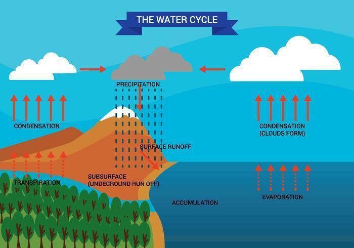
A drainage basin is the area of land that is drained by the river and its tributaries. When a droplet of water falls onto the land (as precipitation), gravity will make sure that the water is 'pulled' downhill to return to the sea.
The Water Cycle
The water cycle is also known as the hydrological cycle.
Seas and oceans contain 97% of the world's water, and ice holds 2%. That leaves just 1% of the world's water as fresh water on land or in the air.
This water is recycled again and again through the process of evaporation, condensation and water transfers such as surface runoff.
Page 3
Information
- Description
- IGCSE Geography Note on Geography 2.2 Rivers, created by tamay dela on 20/09/2019.
- Created by
- tamay dela
- Views
- 1
- Rating