Description
|
|
Created by Taylor Hubbell
almost 7 years ago
|
|
Page 1
THE PLATE TECTONICS
In 1912, German Scientist named Alfred Wegener developed the Theory of Continental Drift. It states that the Earths crust is divided into 20 plates. 300 million years ago a supercontinent called Pangea was created.
Subduction is a recycling of the Earths crust. One plate moves under another into the mantle where its is melted Collision occurs when forces push the continental plates directly together. Mountains are created as a result. Divergence occurs when the plates move apart creating more crust.
Page 2
Glacier Landforms
Moraine - Ridges of till deposited at the edge of a glacier. The glacier bulldozes the till as it moves across the land. Eskers - An Esker is a long narrow ridge of sand and gravel that used to be the bed of a stream flowing under glacier. Drumlins - If a glacier hits a boulder it can't move, sand, gravel, and rock are deposited in front of the boulder framing a log low hill. Till Plains - Layer of sand, gravel and clay deposited under a glacier when it melts. Forms a gently rolling/ flat plain. Striations - As a glacier moves over the ground it picks up bit of rock. These rocks leave deep striations n bedrock as the glacier moves.
Page 3
Glacier Landforms
Types of Glaciers Continental: largest type of glacier. It covers about 5 million km Alpine or Mountain: small glacier that occupies U-shaped valley on a mountain
How Glaciers are Formed Earths climate cools and some snow lasts through the summer over thousands of years snow gets deeper and deeper. Weight of the snow causes bottom layers o be compressed into ice.
Glaciers move downhill from gravity They move 1 cm a day
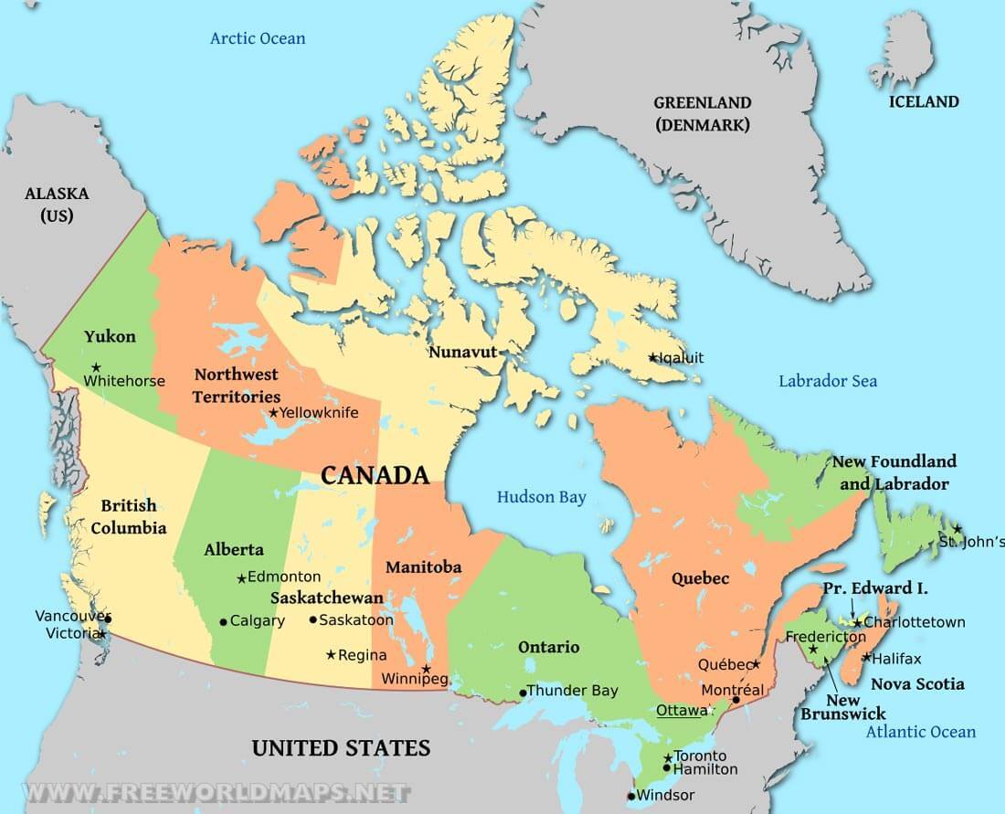
Page 4
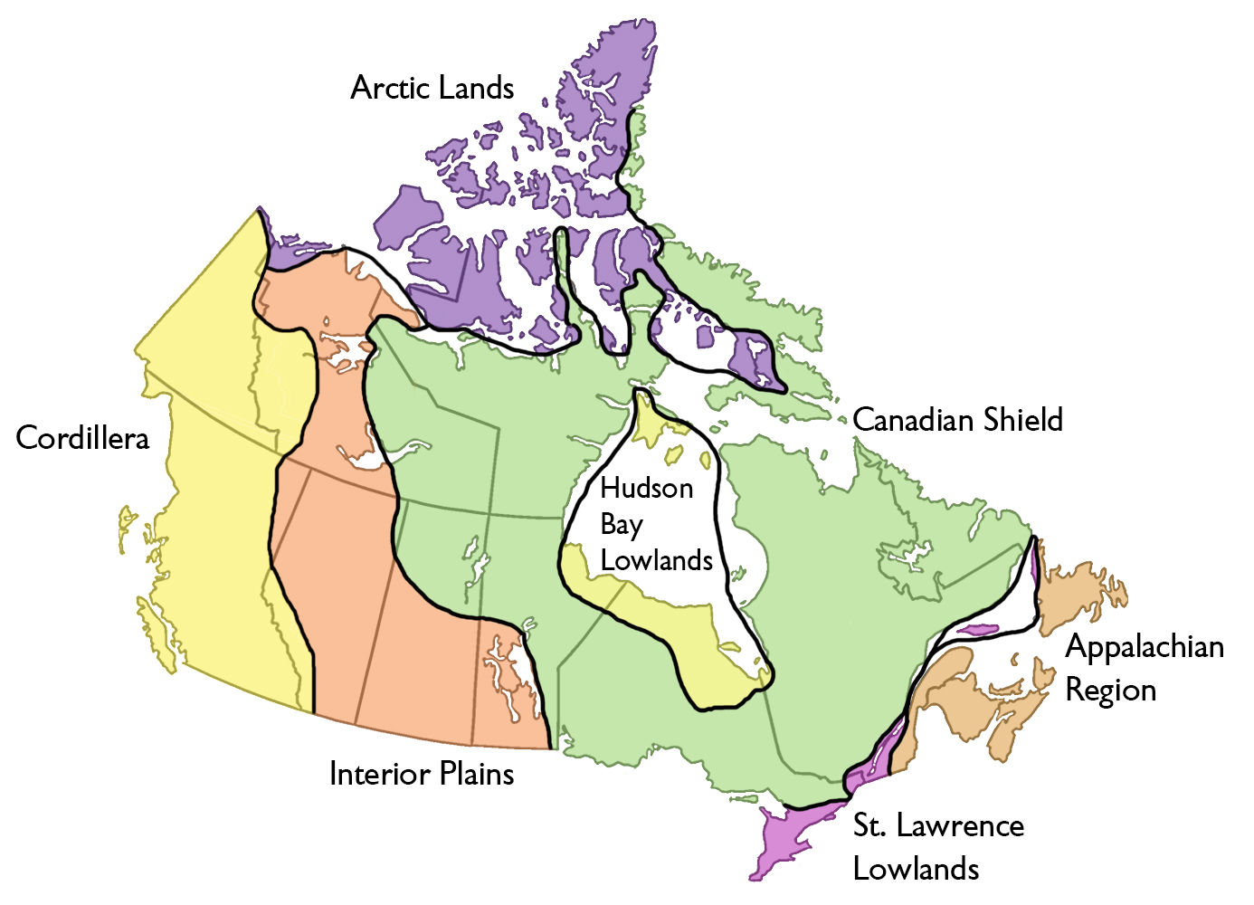
Canada's Landforms
Western Cordillera - High, rugged mountains, Boreal forest, thin infertile soil Interior Plains - Level to hilly, Grasslands to Boreal forest, very deep, highly fertile soil Canadian Shield - Rolling hills & Lake basins, Boreal and mixed forests, thin infertile soil Hudson Bay Lowlands - Rolling hills & Lake basins, Wetlands and small coniferous trees, thin infertile soil Great Lakes St. Lawrence Lowlands - Level to hilly, Mixed & deciduous forests, deep fertile soil Appalachians - Low, rounded mountains, Boreal and mixed forests, thin infertile soil Arctic Lowlands - Level to hilly , Barren land- tundra, little to no soil Arctic Cordillera - High, rugged mountains, barren land- tundra, little to no soil
Page 5
Canada's Vegetation Region
Tundra Boreal Forest (Taiga) Mixed Forest Deciduous Forest Grassland Cordilleran Vegetation West Coast Forest
Page 6
Factors Affecting Canada's Climate
Climate Regions in Canada Arctic Taiga Cordilleran Pacific Maritime Boreal Prairie Southeastern Atlantic Maritime
Factors Affecting Climate Latitude Ocean Currents Winds and Air masses Elevation Relief Near Water
Page 7
Canada's Climate
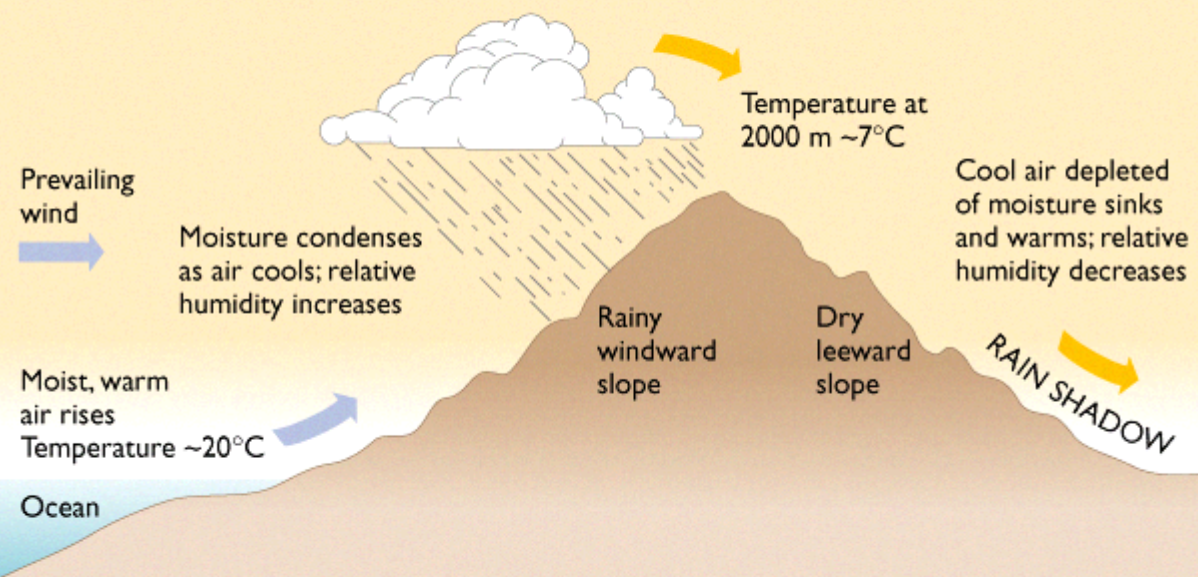
Latitude affects climate because the effects of the sun's energy is spread over the further north or south from the equator we are Ocean Currents have an effect on climate by cooling air masses over warm currents and warming air masses over cold currents The Gulf Stream is a warm current which creates toddy conditions near Newfoundland and Labrador An Air Mass is a large volume of air that has the temperature and moisture characteristic of the area in which it forms. The prevailing winds in most of Canada moves these air masses from West to East When two Air masses from High Arctic and the Gulf of Mexico meets its called the Polar Front The Jet Stream is a fast moving current of air high in the atmosphere that controls the location of the Polar Front Most rainfall in Ontario in Frontal Rainfall As moist air rises up the slope of a mountain range, it expands, cools and condenses into rainfall snow As the air descends on the far side, it contracts and warms up. The air's ability to hold moisture increases and there is little rainfall . This creates a Rain shadow or Dry Area on the leeward slope
Page 8
Continental Vs. Maritime Climate
Maritime Coastal Locations have temperatures that are moderated by proximity to large bodies of water. The range between highest and lowest average temperatures is relatively small. (under 25°C) There is a high amount of precipitation in these locations (over 1000mm) West or East Coast? over 0°C is West Coast and Under 0°C is East Coast Continental Areas located far inland away from bodies of water have a greater range of high and low temperatures averages. (over 25°C) Less precipitation (under 1000mm)
Page 9
Precipitation
In Frontal precipitation a cool air mass meets a warm air mass. In Relief precipitation, air cools as it rises up over a mountain barrier In Convection precipitation, summer air masses are heated, rise, cool and condense into rainfall
Page 10
Soil
A True Soil consists of four main parts: Minerals Bacteria and Organic Materials Air Moisture
Minerals Minerals in the soil come from parent material. This is usually rock, but can loose materials deposited by glaciers, wind or a river. Minerals become part of the soil when rock is broken down by weathering into smaller particles Bacteria and Organic Materials Humus is formed when plants and animals that have died are decomposed by bacteria in the soil. Air Humus helps provide air in the soil because it is loosely packed and has many air pockets Moisture Water dissolves nutrients in the soil and makes them available for plants to draw up in their root systems Water is also needed in chemical and physical processes that weather rock and decay organic materials
Page 11
Soil Types
Loam A well balanced moisture of sand, clay and humus results in loam. The best soil for plant growth Leached Soil In areas of great rainfall, the soil has a continuous downward movement of water that dissolves away the nutrients . This results in a thin topsoil layer. Leached soils can be improved with the addition of natural or chemical fertilizers Calcified Soil In drier climate areas, the movement of water is reversed and is in an upward direction As the water evaporates in the topsoil, more water is drawn from below. Called the Capillary Action As the water evaporates, dissolved minerals, especially calcium, are deposited in the topsoil.
Page 12
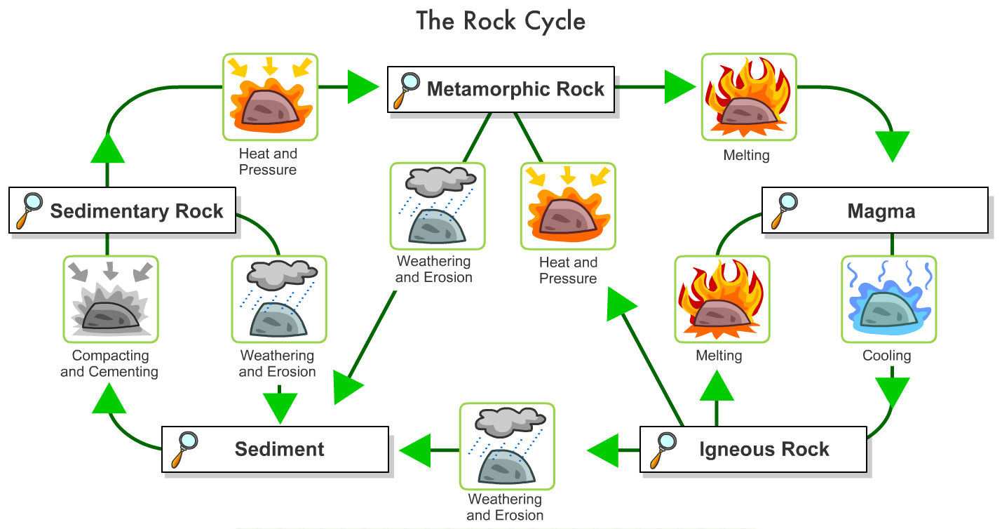
Rock Types
Igneous Rocks are formed as magma cools and solidifies. When magma cools slowly deep in the earth it forms an intrusive igneous rock, such as granite. Over time, as the layers rock above it are eroded, these rocks may come to the surface. When a volcano erupts it spew out lava, which cools rapidly and forms materials such as basalt or obsidian. These rocks are called Igneous Extrusive Sedimentary are formed by the erosion of other rocks and the sediment is often carried great distances by wind or water and then deposited distinct layers that are eventually compressed into sedimentary rock. Metamorphic Rocks are rocks of any type that are put under heat and/or pressure deep inside the earth. Thus the rock transform into a new type of rock.
Page 14
Renewable Vs. Non-Renewable
Renewable Resources that grow back within our lifetime. They will replace themselves Fishing Forestry Water Non-Renewable Resources that can only be used once. Not in our lifetime Minerals Land
Page 15
Types of Industries
A Primary Industry extracts resources from the ground, water or air. They are located where ever resources are found. Secondary Industries turn raw materials into things people need and use. They are located near resources, workers, power sources, transportation routes and customers Tertiary Industries are also called service industries. They are located where ever they are needed. Shopping Malls Banks Schools Quarternary involves the processing of information. Jobs such as computer programming, accountants, and researchers are considered to be in this category Basic Employment brings in outside money to the community Non-Basic Employment re-circulates money within the community
Page 16
Farming in Canada
The Canada Land Inventory has divided land into seven categories, based on its suitability for agriculture Class 1 is the best area for agriculture. It has no land or climate limitations. Only makes up .5% of Canada's land Class 7 has no capability for agriculture due to land and climate limitations . Class 7 makes up 86.8% of Canada's land
Intensive Farming is common is densely populated areas such as southern Ontario, southern Quebec and B.C's Fraser River Valley Farms are small but produce high profit products using large investments in labour and machinery Produces fruits, vegetables, dairy products, poultry and hogs. These items are perishable and need to be produced close to markets. Extensive Farming occurs where population density is low and land is inexpensive Farms are generally large and highly mechanized, needing few labourers Products include cattle, grain, and oilseed
Page 17
Population Pyramids
Demographers identify 3 stages of life where we play different roles Children (under 15) Working Adults (15-64) Older Adults (65-over) Demographers assume children and older adults do not work or contribute financially to society and are supposed by working adults The two groups not working are called the dependency load Which is 31% of the population
Page 19
Immigrant Classes
Economic Class- 62% Family Class- 25% Refugee- 9%
Economic Class People with a skill, trade or profession that is in demand Business people/ investors Have $ to start a business or to invest in one Point System 67/100- to come to Canada Points for education background Job experience Language ability Family Class A family member in Canada can sponsor direct/immediate family members -They are legally obligated to financially look after the family members for up to 10 years if they can't find a job Refugee Class People facing cruel or inhumane treatment as a result of their ethnicity, religion, sexual orientation, or political beliefs -Persecution
Page 20
Sustainable Development
Economic development that is conducted without depletion of natural resources.
Page 21
Global Warming
GHG is a gas in an atmosphere that absorbs and emits radiation within the thermal infrared range. This process is the fundamental cause of the greenhouse effect. The primary greenhouse gases in Earth's atmosphere are water vapor, carbon dioxide, methane, nitrous oxide, and ozone. A carbon sink is anything that absorbs more carbon than it releases as carbon dioxide. Carbon source refers to any carbon containing molecule (carbohydrate, amino acid, fatty acid, CO2) used by an organism for the synthesis of its organic molecules. Fixed carbon is the solid combustible residue that remains after a coal particle is heated and the volatile matter is expelled. Ocean Acidification (OA) is a term used to describe significant changes to the chemistry of the ocean. It occurs when carbon dioxide gas (or CO2) is absorbed by the ocean and reacts with seawater to produce acid.
Page 22
Ecological Footprints
Ecological Footprint is a measure of the load by a given population on the natural environment Livability- all the characteristics of a community that contribute to its quality of life Sustainability- improving the quality of life while living within the carrying capacity of the ecosystem
Page 24
The Human Development Index (HDI) is a composite statistic of life expectancy, education, and per capita income indicators, which are used to rank countries into four tiers of human development. Gross National Happiness (GNH) is a development philosophy as well as an index which is used to measure the collective happiness in a nation. A House Price Index (HPI) measures the price changes of residential housing. The Happy Planet Index measures what matters: sustainable wellbeing for all. It tells us how well nations are doing at achieving long, happy, sustainable lives. Gross domestic product (GDP) is a monetary measure of the market value of all final goods and services produced in a period (quarterly or yearly).
Page 26
Climographs
Temperature Range Subtract the lowest month from the highest month to find the annual range of temperatures Average Annual Temperature Add the temperatures together then divide by the number of temperatures Total Precipitation Add the precipitations together
Want to create your own Notes for free with GoConqr? Learn more.