Page 1
Rivers
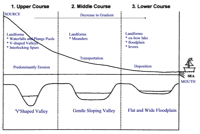
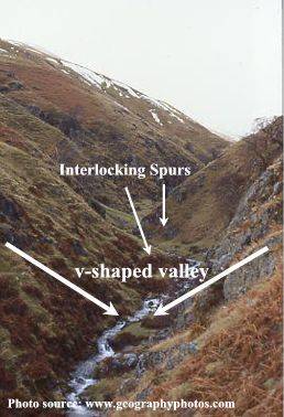
Upper course Sourse: this is were the river starts. It usually starts in the mountains via a stream v- shaped valleys: because the river is at its steepest point the erosion stronger and overtime the river has cut through the rock leaving a steep v-shaped valley.interlocking spurs: these are created when rivers have to flow around an obstacle for instance hard rock. This leaves what looks like snake like stream with the rocks jutting out overlapping.
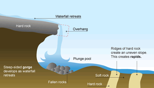
Waterfalls: Waterfalls are formed when soft rock is eroded underneath the hard rock above it. As the rock retracts t leave a hanging cliff. When the hanging cliff is to heavy and gravity overcomes the forces that are keeping it up it falls into a plunge pool. Overtime the process repeats and this leaves a steep sided gorge. rapids: Near waterfalls there is uneven rock types and this creates an uneven surface this intern causes there to be rapids as the water flows over the rock.
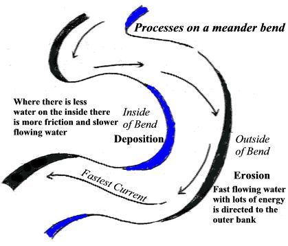
Middle courseTransportation of rocks mainly occurs herMenders: are bends in the river. They are formed by a combination of erosion and deposition. The faster water travels around the outside of the bend, eroding the banks through abrasion and hydraulic action. This creates a steep river cliff. On the inside of the bend the velocity is much slower and consequently, deposition occurs creating a slip-off slope.
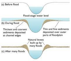
Lower courseMouth: this is where the river meets the Sea and the majority of the rivers load is deposited here as it is very flat land and the river has almost lost all its energylevees: Natural levees form beside a river's banks. They are formed when the river deposits material as it floods. During a flood the river will deposit its heaviest material first (i.e. closest to the banks). Over the years this material builds up to create a levee. The floodplain also gets built up with the fine sediment to create alluvium which makes the floodplain very fertile.Flood plane: this is either side of the river and its the areas susceptible to flooding. Delta: when the river reaches the mouth of the river it drops its load however some of the silt and smaller rocks are carried out a bit further and are deposited. Over thousands of years this has created areas of land. However due to the fat that is practically on sea level and the river is still flowing through the land it means that the delta is very susceptible to flooding
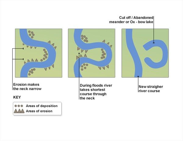
Ox bow lakes a formed by two bends turns in the meander joining together. Due to erosion the two bends will over time come closer together. Then when it flood the river will take its shortest root to the sea and because the neck of the mender is narrow it will flow over the gap in the middle. This causes the river to straighten up leaving the ox and which then dries up.
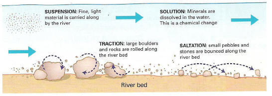
Types of transportationTransportation is the movement of rocks, silt and other materials.Traction- is where there is not enough energy for the river to carry such large rocks so the rocks roll along the bed of the river.Saltation- this is where the small pebbles and other rocks are bounced along the river bed. suspension- the fine silt and small rocks are carried along by river.solution- Particles are dissolved into the water.
ErosionThere are four types of erosion in riversHydraulic action is where the water forces air into cracks in the rocks. The build up of pressure causes the rock, over time, to crack and break apart.Abrasion- is the erosion of the rivers banks and beds by the material being carried in the river itself.Attrition- the large rocks crash into each other n the river and are broken down into smaller pebbles and rocks over the course of the river the majority of the large rocks are smashed and broken down.solution is were the rock are chemically broken down by the slightly acidic water. this mainly occurs in limestone and chalk.
FloodingFlooding occurs when the rivers load is more than the rivers capacity. when this happens the river will over flow onto its banks. Flood plane- the area susceptible to flooding.
solutionshardhard engineering is the use of heavy engineering and building of 'things' as means to prevent or reduce the damage of floodingdam- A dam will control the flow of water reducing the risk of flooding Levves- increasing the hight of the rivers bank will intern create a higher carrying capacity for the river and reduce the risk of flooding.
rivers
transportation And Erosion
flooding
Want to create your own Notes for free with GoConqr? Learn more.