5847334
Description
Quiz by tsampikos pompou, updated more than 1 year ago
|
|
Created by tsampikos pompou
almost 8 years ago
|
|
Question 1
Question
260 After establishing contact with Athina Radar for MATZ penetration and receiving Radar Advisory Service, the controller asks you to turn onto a compass heading of 045 to avoid fast moving fighter jet traffic. Assuming deviation is 6o W, what is the heading? (T)
Answer
-
O 042°
-
O 048°
-
O 054°
-
O 045°
-
O 051
Question 2
Question
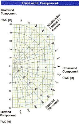
261 The surface wind for take off is given as 245/17 knots. The maximum demonstrated crosswind for the aircraft is 12 knots. Which of the following runways are within the limitations of the aircraft? (Fig.13)
Answer
-
O 25,21
-
O 25,31
-
O 31 only
-
O 25 only
Question 3
Question
262 VOR reception may be affected by
i. night effect
ii. atmospheric static
iii. terrain surrounding the station
iv. aircraft altitute
v. the height of the VOR station
The correct combination is
Answer
-
O (iii) (iv) and (v)
-
O (I) (ii) and (iii)
-
O (I) (iii) (iv)
-
O all of those
Question 4
Question
263 An aircraft is flying from Lamia to Ioannina (90 NM) away, with a required track of 304°(T). The initial heading is 314(M). Var 2°E. the expected drift is:
Answer
-
O 12 port (12L)
-
O 10 starboard (10R)
-
O 8 port (08R)
-
O 8 starboard (08R)
Question 5
Question
264 Operational Navigational Charts (ONC) and Tactical Pilotage Charts (TPC) as those cover the Hellenic area, are
Answer
-
O orthomorphic conical projection of Lambert
-
O true oblique cylindrical projection of Mercator
-
O of azimuthal stereographic projection
-
O of azimuthal gnomonic projection
Question 6
Question
265 In the ideal chart should:
i. Not exist orthomorphic depiction
ii. Scale be constant and true
iii Exist orthomorphic and isochoron depiction
iv. Angles be measured and depicted precisely
v. Great Circle or Rhumb lines be depicted with straight lines
vi. The Latitudes and meridians are cut with 90 degrees angle.
vii. Not exist orthomorhic and isochoron depiction
viii. Great Circles and Rhomb lines depicted as curved lines
Answer
-
O (ii) (iii) (iv) (v) (vi) are correct
-
O All of them are correct
-
O (i), (iv) (vi) (viii) are correct
-
O (ii) (vi) (vii) (viii) are correct
Question 7
Question
266 Isogonal is ………(i)…………and agonic line is………(ii)……………
Answer
-
O (i) a line through places of equal variation , (ii) a line joins places of zero magnetic variation.
-
O (i) a line of equal angle , (ii) a line of unequal angle
-
O (i) a line of equal magnetic dip , (ii) a line joins places of zero magnetic dip.
-
O (i) a line joins places of zero magnetic variation , (ii) a line joins places of equal variation.
Question 8
Question
267 Conformal (orthomorphic) chart in aviation means:
Answer
-
O Angles can be measured correctly
-
O Angles of direction be equal
-
O The Great Circles are exactly straight lines
-
O Parallels are at 90° to the meridians as seen on Polar gnomonic chart
Question 9
Question
268 What distance on the Earth represents 5.2 inches on the chart of Cyprus (1/250.000)
Answer
-
O 18,4 NM
-
O 16,2 NM
-
O 19,8 NM
-
O 25,0 NM
Question 10
Question
269 9'' on the chart of Greece scale of 1/500.000 equal 62 NM. How many kilometers represent 9 inches on the chart of Cyprus, scale of 1/250.000
Answer
-
O 57,5 km
-
O 62 km
-
O 120 km
-
O 32 km
Question 11
Question
270 Navigational Chart of scale 1/250.000 as those depict the U. Kingdom or Cyprus area are based on:
Answer
-
O transverse cylindical projection of Mercator projection
-
O conical projection of Lambert projection
-
O azimuthial projection
-
O none of them
Question 12
Question
271 ''A line on the chart in a particular position will have the same direction as exactly corresponding line on the earth at the same position.'' This ιs called":
Answer
-
O conformality
-
O non conformality
-
O true projection
-
O modified projection
Question 13
Question
272 Flying at FL 125, the reception range of VHF airborne communication transceivers with a sea level situated ground station, is approximately:
Answer
-
O 140 NM
-
O 100 NM
-
O 150 NM
-
O 50 NM
Question 14
Question
273 The earth's shape is best described as:
Answer
-
O Oblate spheroid
-
O Round.
-
O Sphere
-
O Ellipsoid.
Question 15
Question
274 (i) Meridians are rhumb lines, (ii) Parallels are rhumb lines
Answer
-
O Only (ii) is correct
-
O Only (i) is correct
-
O (i) and (ii) are correct.
-
O (i) and (ii) are wrong.
Question 16
Question
275 Only one GC can be drawn between two points on the earth's surface. This is:
Answer
-
O Correct.
-
O Depends on many coefficients.
-
O Not correct.
-
O Correct if the two points are at different latitudes.
Question 17
Question
276 A nautical mile is:
Answer
-
O 1 minute of geographical latitude
-
O 1 minute of geocentric latitude
-
O 1852 m or 6080 ft.
-
O 1610 m or 5280 ft.
Question 18
Question
277 The radius of the earth in NM is approximately:
Answer
-
O 3440 NM
-
O 3930 NM
-
O 6666 NM
-
O 6700 NM
Question 19
Question
278 A kilometre is:
Answer
-
O 1/10000 of the distance from the equator to the pole.
-
O Exactly 1852 SM.
-
O 0.1 X 1000000 mm.
-
O Twice the diameter of the earth.
Question 20
Question
279 Automatic computing equipment in an aircraft that accurately measures the groundspeed in terms of standard nautical miles (FMS or GPS…..) and then uses this to calculate geographical co-ordinates using 1 nm = 1852 m, will be least accurate when flying:
Answer
-
O North/South in equatorial regions
-
O East/West around the equator
-
O East/West around parallel of latitude 30°
-
O East/West around parallel of latitude 45°
Question 21
Question
280
The length of a nautical mile:
Answer
-
O Increases with altitude
-
O Decreases with altitude
-
O Remains constant with altitude
-
O Depends only on location flight takes place.
Question 22
Question
281
A rhumb line is best defined as:
Answer
-
O A line on the earth of constant true direction
-
O A line on a chart cutting all meridians at the same angle
-
O A straight line on chart.
-
O A curved line on chart.
Question 23
Question
282 A parallel of latitude is a:
Answer
-
O A RL and in a special case can also be a GC.
-
O A RL and can never be a GC.
-
O A small circle and can never be a GC
-
O Nothing of those
Question 24
Question
283 At 10:00 UTC the a/c from it's position at 3000 ft (OAT +10?C), pulls up and climbs en-route with constant IAS 180 kts, on track 090? and with climb rate of 1000 FPM, up to FL250(OAT -30?C).
The estimated wind for the entire climb is 040?/30kts. What time is estimated to be established at FL250 and what should be it's position according to Dead Reckoning calculation?
Answer
-
O 10:22 UTC 74NM
-
O 10:22 UTC 78NM
-
O 10:25 UTC 74NΜ
-
O 10:25 UTC 78NM
Question 25
Question
284 An a/c departs from Florina aerodrome and flies to destination (Alexandroupolis LGAL) at FL200 (OAT -24?C). It is supposed to be established over its destination airport at 2000 ft (OAT +12?C).
The desired track is 090?(T) with IAS 200kts. The estimated wind in the mid altitude of descent is 320?/40. The descent rate is 900FPM. How long does it take to start descent and what should be it's position by Dead Reckoning calculation before descent begins?
Answer
-
O 20min 87nm before "Dimokritos"
-
O 18min 87nm after Florina.
-
O 22min 97nm before "Dimokritos"
-
O 24min 100nm after Florina.
Want to create your own Quizzes for free with GoConqr? Learn more.