
Mind map
Rivers
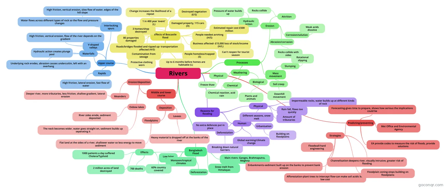
Mind map: Rivers geography
Map content
Rivers
Upper course
- Waterfalls
- Underlying rock erodes, abrasion causes undercuttin, left with an overhang
- Hydraulic action creates plunge pool
- Rapids
- High friction, lateral erosion, fast flow of water
- V-shaped valleys
- High friction, vertical erosion, flow of the river depends on the gradient
- Interlocking spurs
- High friction, vertical erosion, slow flow of water, edges of the hill slope
- Water flows across different types of rock so the flow and pressure changes
- Waterfalls
Middle and lower course
- Erosion/deposition
- Meanders
- Deeper river, more tributaries, less friction, shallow gradient, lateral erosion
- Oxbow lakes
- River sides erode, sediment deposited
- The neck becomes wider, water goes straight on, sediment builds up seperating it
- Meanders
- Deposition
- Levees
- Heavy material is dropped off at the banks of the river
- Floodplains
- Flat land at the sides of a river, shallower water so less energy to move sediment
- Levees
- Erosion/deposition
Processes
- Erosion
- Hydraulic action
- Pressure of water builds up
- Attrition
- Rocks collide
- Abrasion/corrasion
- Rocks collide with sides
- Corrosion/solution
- Weak acids dissolve
- Hydraulic action
- Weathering
- Physical
- Freeze thaw
- Chemical
- Chemical reaction, acid rain
- Biological
- Plants and animals
- Physical
- Mass movement
- Slumping
- Rotational slipping
- Soil creep
- Downhill movement
- Slumping
- Erosion
Reasons for flooding
- Human
- Urbanisation
- Building on floodplains
- Global warming/climate change
- Deforestation
- Breaking down natural barriers
- No extra defences put in place
- Urbanisation
- Physical
- Rain fall, flows too quickly
- Amount of tributaries
- Different seasons, snow melt
- Impermeable rocks, water builds up at different kinds of rock
- Human
Effects of Boscastle flood
- Destroyed vegetation (E/S)
- Damaged property, 115 cars (H)
- People needed airlifting (H/S)
- 1 in 400 year 'event' (L)
- Change increases the likelihood of a repeat
- Roads/bridges flooded and ripped up- transportation affected (H/S)
- Business affected- £15,000 loss of stock/income (H/L)
- Can't reopen for tourist season
- People homeless/trapped (S)
- Up to 6 months before homes are habitable (L)
- 3 homes/shop destroyed
- 80 properties damaged
- Estimated repair cost £500 million
- Contamination from sewage
- Protective clothing worn
Bangladesh Flood
- Main rivers- Ganges, Brahmaputra, Meghna
- Low lying land
- Snow melt from Himalayas
- Monsoon/tropical climates
- Deforestation
- Effects
- 60% country covered
- 1000 patients a day suffered Cholera/Typhoid
- 700 deaths
- 2 million acres of land destroyed
Predicting/preventing
- Forecasting-gives time to prepare, shows how serious the implications could be
- Met Office and Environmental Agency
- EA provide codes to measure the risk of floods, provide solutions
- Strategies
- Floodwall-hard engineering
- Channelisation-deepens river, visually intrusive, greater risk of flooding
- Afforestation-plant trees to intercept flow-can make soil acidic but low cost
- Floodplain zoning-stops building on floodplains
- Enbankments-sediment built up on the banks to prevent bank erosion
Information
- Description
- Mind Map on Rivers, created by Caitlin Horton on 24/01/2014.
- Created by
- Caitlin Horton
- Views
- 10
- Rating