
Mind map
Climate basics
Map content
Climate basics
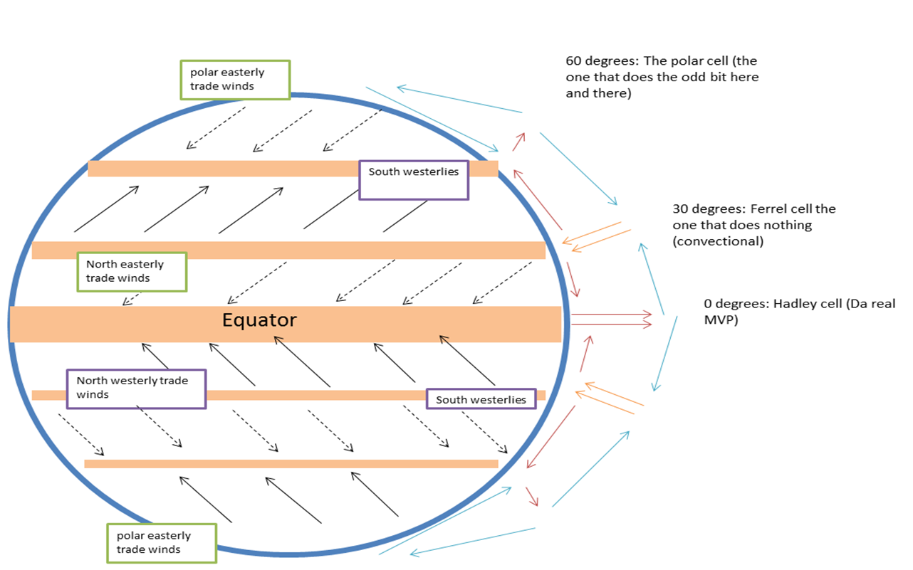
Tricellular model
- At the equator, the sun warms the earth, which transfers heat to the air above causing it to rise. the rising air creates a low pressure, clouds and rain. this is called the intertropical convergence zone.
- As the air rises it cools and moves out to 30 degrees north and south of the Equator, the cool air sinks creating high pressure. Sub tropical jet streams are found here( jet streams are fast moving curents of air)
- The cool air reaches the ground surface and moves as surface winds either back to the equator or towards the Poles.
- The surface winds that blow towards the trade winds. they blow from the S.E in the southern hemisphere. At the Equator, these trade winds meet (converge) in the ITCZ and are heated by solar radiation. This causes them to rise, condense and form clouds.
- Surface winds blowing towards the poles are called the westerlies. thy blow from the NW in the Southern hemisphere and from the SW in the Northern Hemisphere.
- 60 degrees North and south of the Equator, the warmer surface winds meet colder air from the ples. The warmer air is less dense than the cold air so it rises creating low pressure.
- Some of the air joins the Ferrel cell and moves back towards the Equator and the rest joins the polar cell and moves towards the poles. At the poles, the cool air sinks creating high pressure. The high pressure air is drawn back towards the Equator in surface winds.
- The cool air reaches the ground surface and moves as surface winds either back to the equator or towards the Poles.
- As the air rises it cools and moves out to 30 degrees north and south of the Equator, the cool air sinks creating high pressure. Sub tropical jet streams are found here( jet streams are fast moving curents of air)
- At the equator, the sun warms the earth, which transfers heat to the air above causing it to rise. the rising air creates a low pressure, clouds and rain. this is called the intertropical convergence zone.
Ocean currents
- Ocean currents are large-scale movements of water caused by differences in water density. density depends on water temperature and salinity. Currents are affected by surface winds, position of land masses and other currents.
- Ocean currents transfer heat energy from warmer cooler regions. warm ocean currents raise air temperature, which warms the land nearby cool ocean currents lower air tempreture which cools the land nearby.
- Ocean currents form giant loops that travel clockwise in the Northern hemisphere and anti-clockwise in the southern hemisphere. this is because of surface winds- e.g trade winds push water along the Equator, and westerlies push water east between 30 and 60 degrees north and south.
- examples of ocean currents that affect the climate of regions
- The Gulf Stream
- The Gulf stream carries warm water from the Caribbean sea along the east coast of America and across the atlantic to western Europe. The Gulf Stream keeps Europe much warmer than it would be otherwise. Water in the Gulf stream coola in the Northern hemisphere and becomes more dense.
- The Canary current
- The Canary current carries water that sinks from the gulf stream. it is then carried back and cools the west coast of Africa.
- The Gulf Stream
What are winds
- Winds are large scale movements of Air caused by differences in air pressure. Differences in Air pressure are caused by differences in atmospheric heating between the Equator and the poles.
- Winds are part of global atmospheric circulation cells. these cells have a body of warm rising air which creates an area of low pressure and a body of cool falling air which creates an area of high pressure.
- Winds move from the areas of high pressure to Areas of Low pressure. There are three main types of global circulation cells.
- Hadley
- Ferrel
- Polar
Images and files in the map
Information
- Description
- AS - Level Geography A level (A2 Physical weather and climate) Mind Map on Climate basics, created by Aidan S.G on 23/05/2017.
- Created by
- Aidan S.G
- Views
- 1
- Rating