
Mind map
Taiga Forest
Map content
Taiga Forest
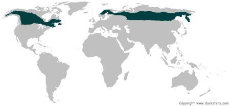
Location
- Countries
- Russia
- Canada
- Alaska
- Finland
- Sweden
- Norway
- Occupies 17% of the Earth's land surface
- 50 N - 60 N of the equator
- Not located in the south due to little land space
- Countries
Climate
- Short growing seasons
- Long, cold winters
- Warmest temperatures around 20 C
- Warmest month is July
- Coldest temperatures can be as low as -50 C
- Coldest month is January
- Receives between 300-1000mm of annual precipitation.
Uses
- Logging
- Softwoods
- Fir
- Larch
- Pine
- Hardwood
- Spruce
- Softwoods
- Wood and paper products
- Resin of trees used
- Mining
- Tar sands
- Can be used to make oil
- Fracking
- Open pit mining
- More precious minerals
- Iron
- Silver
- Gold
- Diamond
- Uranide
- Tar sands
- Fuel
- Coal
- Methane
- Natural gas
- Logging
Management
- Selective logging
- Trees are only felled when they reach a particular age or height.
- The trees for logging are marked so that only the ones selected are felled.
- Can help to prevent the loss of too many trees.
- Allows the younger trees to grow and replenish the forest
- Education
- Helps those who are dependant on the forest understand why it is still needed
- Helps people to understand the consequences that their actions could bring to the environment, and how this would affect them.
- Afforestation
- Opposite of deforestation
- New trees are planted to replace those that have been cut down
- Helps to replenish the forest.
- Forest reserves
- Protects areas of forest from exploitation
- Protects animals that are within the reserves as well as the plantlife
- Monitoring
- Uses satellite technologies to check that activities going on those areas are legal and follow sustainability guidelines.
- Selective logging
Soil
- Very thin layer of soil
- Lack of decomposition
- Weathering due to the cold
- Acidic due to leaching from rainfall
- Very little nutrients
- Podzol
- Ash grey on top
- Red underneath
- Very rich in iron
- In layers due to very few worms mixing the soil
- Very thin layer of soil
Nutrient cycle
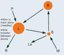
- Litter is the largest store
- Cold weather means it takes longer for matter to decompose
- Harder for nutrients to reach the soil due to the layers of ice and snow.
- Biomass is relatively low
- One layer of coniferous trees.
- Very little undergrowth
- Not that many species
- Soil has very few nutrients
- Leaching
- Not much decomposes
- Podzol soils have a very low fertility potential
- Litter is the largest store
Flora and fauna
- Plant adaptations
- Evergreen trees
- Do not lose their leaves
- Would take up too much energy in the spring to regrow all the leaves again.
- Do not lose their leaves
- Needle shaped leaves
- Reduces water loss
- Helps remove snow quickly from the branches
- Stops the branches from breaking from too much weight
- Conical shape
- Helps remove snow from the branches
- Stops the branches from breaking under too much weight
- Helps remove snow from the branches
- Evergreen trees
- Animal adaptations
- Hibernation
- Short tails
- Avoid frostbite
- Coat changes colour during different seasons
- White in winter
- Brown in summer
- Better camoflage
- Layer of insulation
- Feathers
- Fur
- Migrate during winter and return in the summer
- Plant adaptations
Images and files in the map
Information
- Description
- Mind map on the taiga forest. Unit: forests under threat
- Created by
- Abbey Williams
- Views
- 3
- Rating