
Fichas
Geology 103 study guide
Fichas del conjunto (200)
- 1How did early geologists attempt to determine age of the earth?Scripture, then melting iron balls and determining their cooling time, then by measuring thickness of crust or saltiness of the ocean.
- 2George Cuvierrecognized extinction of marine fossils, some fossils have no living relatives, younger strata held fossils similar to younger organisms
- 3William Smithidentified rock layers by fossils, made first geological map of England, used fossils for correlation and stratagraphy.
- 4How did the geological system develop?created using cuvier and smiths ideas, the periods on the column are smith/cuviers system. it is used to understand and correlate stratigraphy and determine historic age of a specific area.
- 5development of geological time unitscame from the geological system. represents major geological and biological events, broken up into eons (Largest span of time), eras, periods, and epochs. used same way as geological system, but more accurate.
- 6relative datingarranges geological events in order by comparison to each-other. no numerical date.
- 7absolute datingradiometric decay to determine numeric age
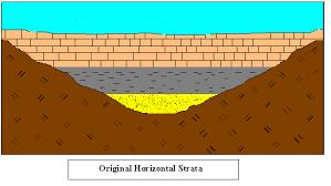
- 8original horizontalsediment is always originally deposited horizontally
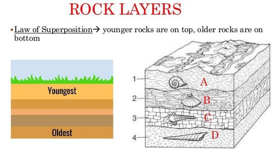
- 9Superpositionoldest rocks at the bottom, youngest rocks at the top.
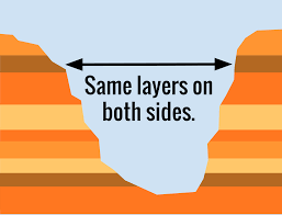
- 10lateral continuityRock layers extend in all directions until terminated.
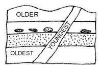
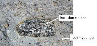
- 11Cross-cutting relationshipintrusion is younger than intruded.
- 12Correlationtime-equivalency in stratigraphy.
- 13inclusionsthe included is older than the rock they are included in
- 14Fossil assemblagegroups of fossils found together.
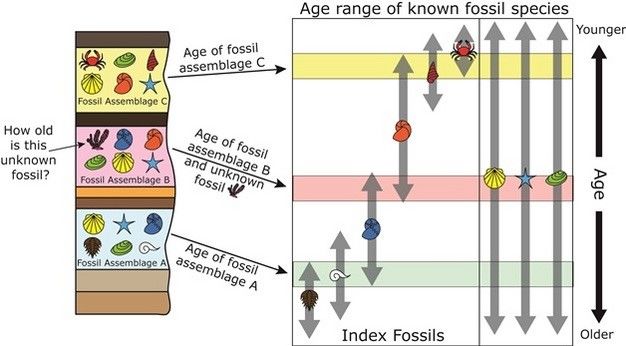
- 15index fossilfossil from a narrow time range used to date and correlate strata.
- 16fossil successionolder on the bottom
- 17overlapping/concurrent fossil rangeoverlapping range zones where 2 plus fossils from different time ranges co-exist
- 18unconformablemissing interval in geological time record.
- 19conformabledeposited in concurrent sequence.
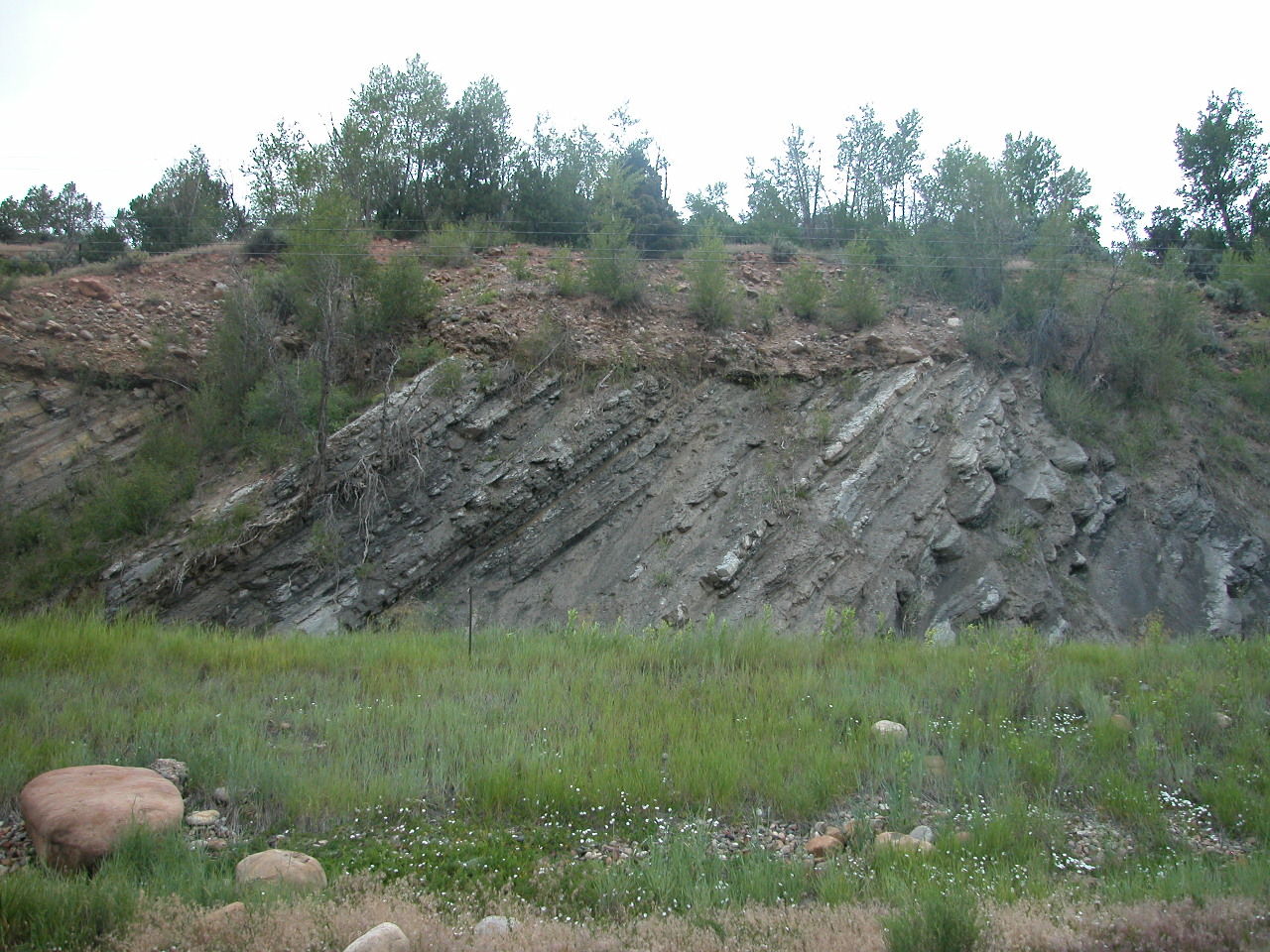
- 20Angular Unconformitydeposits are tilted
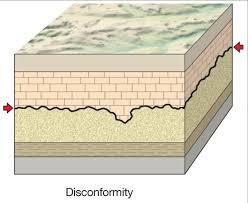
- 21DisconformityBreak in sedimentary sequence.
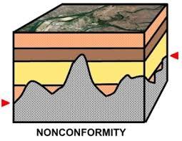
- 22nonconformitysedimentary deposited on igneous or metamorphic
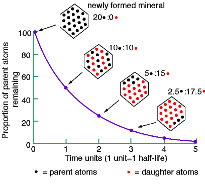
- 23Radioactive half lifethe ratio of parent to daughter. half life is when half of the original parent isotope is gone.
- 24Alpha emissionsmass is REDUCED by 4. Atomic number is REDUCED by 2.
- 25Beta EmissionAtomic Number GOES UP 1. Mass stays EQUAL.
- 26Electron CaptureAtomic number goes DOWN 1. Mass stays EQUAL.
- 27Limits of radiometric dating.must date something from a closed system, most accurate dates are from igneous.
- 28Closed systemThe item being dated has been protected from the elements (heat, pressure, rain, etc.) so as to keep the parent/daughter ratio in tact.
- 29Carbon 14 datingCompares ratio of carbon 12 to carbon 14.
- 30Stratigraphyorder and relative position of rock layers in relation to geologic time
- 31P-Wave Velocity(Fastest sisemic wave)
Travels through solid and liquid
Compression (Push-pull)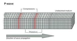
- 32S WaveSlower Wave -Shear wave (Up-down)
Moves through solid and plastic
Will not pass though liquid.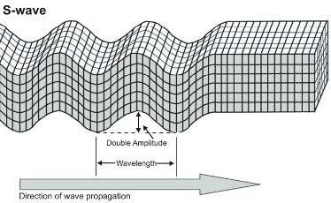
- 33P and S wave Velocitydependent on the density and elasticity of material they travel through.
denser material = Faster wave - 34Shadow Zonearea where wave does not travel
s wave- Liquid core stops wave
P wave- Waves are refracted by liquid core. - 35Moho depth and significancedepth: Beneath Continents-Av. 39 km
Beneath sea floor 5-10 km
Significance- Separates crust from mantle
discovered by velocity of waves - 36Gutenberg depth and significanceDepth: 2,900 km
significance- Separates core from mantle
Discovered by p waves, shadow zones, and velocity - 37Lehman depth and significanceDepth:220 km
Significance- separates inner and outer core
Discovered through p waves arriving faster through core - 38Oceanic crust thickness, composition, and specific gravityThickness-5-10 km
Composition- Basalt
Gravity- 2.9
Denser than continental - 39Continental crust thickness, composition, and specific gravityThickness: Av. 35 km (20-90 km)
Composition: granitic, silica rich
S.G.-2.7
less dense and thicker than oceanic - 40Mantle thickness and compositionThickness- 2,900 km
Composition-perdotite - 41Core thickness, compositionthickness- 3480 km
Composition- iron and nickle - 42Upper mantleLithosphere- solid basalt/granite 70 km thick
Asthenosphere- Plastic, denser - 43Lower mantleThickness- 2900 km
solid- Thicker and denser than upper mantle - 44Low velocity zonelowest 200 km of mantle
p wave velocity increases
partially molten mantle - 45asthenosphereplastic and denser than lithosphere
- 46geothermal gradientearths temperature increase with depth
averages 25 C/km
greatest change is in the crustal area - 47methods of geothermal heat flowgreater in volcanic areas, rises faster beneath spreading ridges.
- 48internal heat generationproduced by radioactive decay ( isotopes, uranium), crystallization, and heat of formation
heat moves through convection or conduction - 49Crust geothermal gradient800-1200 C
- 50mantle from 100-300 km1200C
- 51core-mantle boundary heat2500-5000 C
- 52gradient of mantle1 C/km
- 53core gradientincreases at outer core
decreases at inner core - 54Seismic Tomography3d imaging the subsurface of the earth using seismic waves caused by earthquakes and explosions
used to better understand core, mantle, and plate tectonic processes - 55Mechanism behind Magnetic fieldconvection currents between inner and outer core due to the difference in temperature, pressure, and composition create energy.
- 56historic behavior of magnetic feild1-5 events every million years-highly variable
last event was 780,000 years ago - 57outer corethick, liquid, made of iron and nickle, 4400 C-6100 C
- 58Fossil evidence of continental driftfossils found on separate continents. continents must have been joined at one point
ex: Mesosauraus: freshwater reptile found in southern Africa and brazil - 59glaciationlarge- scale continental glaciers formed near equators and glacial striations found on land. fossilization showing that south africa used to be at the south pole, and north pole was tropical.
- 60Paleoclimatesmatching folded mountains, glacial deposits, and coal deposits
- 61age, composition, and structure of continental rockspangea would have formed 1 continuous mountain range.
- 62polar wanderingEuropean silurian and permian lava flows pointed to different magnetic pole locations.
- 63Paleomagnetismremenant of magnatism in ancient rocks recording the direction and intensity of earths magnetic poles at the time of the rocks formation
- 64Seafloor spreadingcontinental and oceanic crust move together as a single unit. sea floor moves away from spreading ridges.
- 65magnetic reversalsfinding records of magnetic reversal and magnetic normality in rocks.
- 66age and composition of sea floorbasalt crust is older as it moves away from ridge. introduced idea of sea floor spreading.
- 67normal magnetic polarityneedle of a compass would point north
- 68reversed magnetic polarityneedle of a compass would point south
- 69Divergent boundryplates MOVE AWAY from each other and form all ocean crust via volcanic mountain chains. found primarily in OCEANS.
- 70transform boundries2 plates slide/grind past each other. commonly found with divergent boundries. found offsetting divergent boundries an in ocean.
- 71Oceanic>oceanic is forced under continent in SUBDUCTION.
trench filled with accretionary material.
forms chain of volcanoes due to melting at subduction. - 72oceanic>NO WEDGE. more dense (older) plate is subducted. forms volcanic island arc.
DEEP TRENCHES - 73cont>no subduction zone VERY LARGE MOUNTAIN.
- 74Accretionary materialsediments erroding from cont.
- 75Why alfred wagoners ideas were not supportedthere was a lack of driving mechanism for the plates movement.
- 76deep ocean drilling proofanalysis of crust to support the theory of sea floor spreading.
- 77types of research done on glomar.deep sea drilling, sonar, remote sensing, and submersibles.
- 78origin and significance of hotspotOrigin-place where stationary mantle ploom rises and forms a volcano
significance- forms islands such as hawaii. - 79mechanisms responsible for motion of global platesslab pull- (main mechinism)gravity pulls crust into earth at subduction zone.
convection in mantle
ridge push- ridge erupts, piling matter pushes ridge apart, pushes plates away from divergent boundry. - 80ocean trenchlong narrow depression in ocean floor running parrellel to plate boundry marking a subduction zone.
- 81rock magnetismmagnetic properties of rocks and how they can record the earths magnetic history.
- 82continental volcanic arcoceanic>
- 83island arcOceanic>
- 84Polarity epochsperiod of time where earths magnetic feild is predominantly one of polrity
- 85focusplace in earth where fault moves
- 86epicenterlocation on surface above focus
- 87faultfractured/broken crust crated by stress
- 88elastic reboundexplination for sudden release of energy that causes earthquakes. deformed rocks fracture and then rebound to their original undeformed condition.
- 89aftershocksmall earthquake following the large one
- 90seismographinstrument that detects, records, and measures waves produced by earthquakes.
- 91foreshocksmall earthquake before large earthquake
- 92body wavesp waves and s waves
waves that travle through the interior of the earth - 93surface waveslove waves and rleigh waves
waves that travel on earths surface - 94raleigh wavemove in an elipticle path like a roll. slower than love wave
- 95love wavewave moves similar to s wave, but particles move back and forth on horizontal plane.
- 96body wave vs. surface wavebody wave travles through the earths interior
surface wave travles through the crust - 97location and magnitude calculationsrichter magnitude scale measures total amount of energy released by an earthquake at its source.
location is done by using three siesmograph stations to triangulate the epicenter - 98earthquake risk mapshelps people plan and prepare for for future earthquakes by indicating likelyhood and severity of future eathquakes based on intensity of past earthquakes.
- 99how are siesmic waves used to define plate boundries.sisemic waves can help identify epicenter, and most earthquakes occur in siesmic zones that corolate to plate boundries
- 100shallow quake0-100 km deep
found in divergent, subduction, cont> - 101intermedite earthquake100-300 km
found in subduction, cont> - 102deep earthquakes300-600 km
found in subduction, cont> - 103richter vs momentrichter will not record large differences in upper magnitudes.
moment usus siesmic moment to calculate magnitude more accurately - 104ground motionmost obvious and emidiate effect. fissures can open in the ground, collapsing buildings, falling landmarks. water saturated sediment can liquify.
- 105tsunamilarge wave produced by earthquake, landslide, or volcanic eruption.
- 106liquificationwater filled sediment behaves as fluid , when shaken, ground loses cohesion and the ground begins to flow.
- 107mass wastinglandslide
- 108subsidencelowering of the lands surface
- 109buliding types effected by earthquakessmall buldings are effected more by high frequency waves
tall buldings are effected more by low fequency waves. - 110richter scaleopen ended scale ending at 10 that raises a log base ten for ech magnitude
- 111potential and hazards of earthquake in the nwlikely due to history and location close to multiple fault zones.
- 112normal faulttension- head moves down
- 113reverse faultcompression- head moves up
- 114right/left lateral strike slipshear force. direction dependant on your position relative to fault
- 115tsunami warning systemdetects tsunamis in advance and issues warning. uses coastal tide gauges and sophisticated bouies . pscific one is located near honolulu hawaii.
- 116Compressional Stressrocks are squeezed together by external forces directed towards eachother causing folds and fractures
- 1173 types of compressional stress structuresanticlines and synclines
plunging anticlines and plunging synclines
reverse faults - 118Tensional stressforces act in opposite directions along the same line-stretching an object
- 119types of tenional structuresdomes and basins
normal faults - 120confining pressurevertical stress put on layers of rock from overlying material
- 121high confining pressureincreases rock strength
- 122low confining pressuredecreases strength of rock
- 123shear forceparallel forces acting in opposite directions.
strike slip faults - 124plastic deformationpermanent folding/deformation of solid with no fractures
- 125brittlebreaking and faulting occur
- 126ductilerocks bend or fold like clay
- 127elastic deformationprimary creep
remove stress and rock returns to its original shape - 128brittle deformationlow temperature and pressure
- 129ductile deformationhigh temperature and pressure
- 130yield pointpoint at which a material can no longer form elastically.
- 131Strainhow rocks react to stress
-accumulation of energy in rock due to stress
-causes deformation - 132stressforce per unit area applied to rocks. if stress is passed the yield point, fracture will occur
- 133primary creeplong term low level pressure
deceleration of stress-rate - 134secondary creepplastic deformation
slow strain rate where ductile deformation occurs - 135tertiary creepaccelerated strain rate
rock fails - 136elastic-strain hypothesisthe springing back of rocks after a sudden fault movement, first reasonable hypothesis for earthquakes
- 137strikedirection of line formed by incline plane and horizontal plane
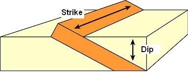
- 138dipmaximum angular deviation of an incline plane from horizontal
- 139strike and diporientation or attitude of geological feature
- 140recumbent folddoes not dip more than 10 degrees
horizontal or semi-horizontal hinge line and axial plane - 141plunging anticlinesanticlines with profile planes that are not perpendicular to the earths surface
- 142synclinedown arched compressional fold where middle rock is the youngest and all strata dips toward the axis
- 143anticlineconvex upward compressional fold, oldest is in the middle and all strata dips away from the axsis
- 144plunging synclinesyncline with profile planes that are not perpendicular to the earths surface
- 145basincircular. strata dips inward and the youngest is in the center
- 146domecircular. rocks dip away from center and center is the oldest
- 147dome/basin vs hills/valleyshills/vallies are created by uplift-tensional (normal faults) pressure, can happen where there are no plate boundries.
- 148dip-slip faultfault in which movement is parallel with the dip of the fault plane
- 149reverse faultdip-slip fault where the hanging wall moves upward reltative to footwall
- 150thrust faulttypre of reverse fault and therefore dip-slip fault where fault plane dips less than 45 degrees
- 151oblique slip faultboth dip-slip and strike slip motions
- 152normal faultdipslip fault where hnaging wall block moves downward relative to footwall
- 153detatchment faultlow angled normal fault
- 154fault block mountainmountains formed via normal faults
- 155horstmountains formed normal faulting
- 156grobbinsvalleys formed by normal faulting
- 157fault scrapvertical offset of ground surface
- 158left lateral strike slipblock accross the fault from the observer would have appeared to have moved left
- 159right lateral strike-slipblock accross the fault from the observer would have appeared to have moved right
- 160crustal upliftforms mountains and platues due to the rise of the earths crust.
- 161roots of mountains2/3 of mountain is crust below the surface protruding into the mantle
- 162isostancy in rooted mountainsearths crust floating in denser mantle
- 163ocianic to continental convergent boundry mountain buildingfaults and folds- creates plutonic and volcanic mountains
ex- cascade mountain range - 164continental-continental mountain buildingcompression and faulting- forms largest mountain ranges, lots of metamorphisis and reverse faults.
ex-Himalayas. - 165oceanic to oceanicdoes not bulid mountains, bulds volcanic islands like hawaii
- 166back arc spreadingformation of oceanic crust of the marginal basins, due to convection system over over a subducting lithospheric plate
- 167mechanism of faultblock mountain bulidingbrakage caused by large amounts of underground pressure and causing mountains
- 168accreted terrains in north america2 types
short distance- transform faults baja and san andreas
long distance exotic terrains
most of west coast formed by this meathod-obvious in fossils, rock types, paleaomagnatism and stratigraphy - 1693 divisions of precambrian eonProterozoic
Archean
Hadean - 170Proterozoic2.5 bybp-541 mybp
- 171Archean4-2.5 bybp
- 172Hadean4.6 bybp
- 173Earliest earthvery hot, no liquid water, no oxygen or atmosphere, no life, ultramafic crust.
- 174free oxygenbanded iron formations and red beds
- 175zirconswithstands metamorphosis, wont weather away on surface area
- 176early earths crustUltramafic , no true continents
- 177early earths platesrapid movement driven by convection
- 178partial meltportion of solid rock is melted
- 179silica richlower melting points
- 180ultramaficmantle-very low silica high iron, earths early crust
- 181maficoceanic- low silica, high iron/mag
- 182intermediatecont-moderate silica, moderate iron/mag
- 183felsiccont-high silica-low iron/mag- melts at lowest temp
- 184sheildancient igneous metamorphosed rocks
- 185platformmetemorphosed sedimentary rock accumulation of sides of sheild.
- 186partially meltultramafic mantle melts to create mafic oceanic crust
- 187partial meltmafic melts to create intermediate and felsic
- 188cratoncore of a continent- made of shield and platform
- 189oldest crustcanadian sheild- gneiss
- 190Archean Rocksgranite, gneiss, greenstone belts
- 191Greenstone Beltsold oceanic crust-named due to their color
- 192atmosphere developed1% by archean
10% by proterozoic - 193atmosphere originmagnetic field developed and volcanic out gassing occurs to produce atmosphere
- 194atmosphere compositionco2, ammonia, and methane
- 195oxygenating the atmosphere1-photo chemical dissociation
2-photosynthesis - 196photochemical dissociationh20 broken up by uv radiation, creates h2 and o2 molecules, self limiting process, forms ozone
- 197photosynthesisplants combine co2 and h2o and release 02
- 198stromatalitesedimetary rocks made of photosynthesising single cell microbes called cyanobacteria
- 199heterotropic vs autotrophicautotrophic- feeds itself
heterotrophic-cant make its own food - 200anaerobicdoes not require oxygen
Información
- Descripción
- Midterm Geology Fichas sobre Geology 103 study guide, creado por Allison Andresen el 02/05/2017.
- Creado por
- Allison Andresen
- Visitas
- 9
- Valoración