
Mapa mental
Regeneration in Plymouth
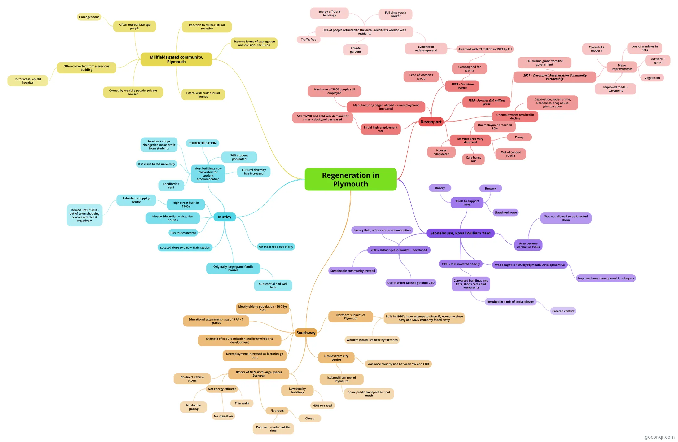
Mind map: Regeneration in Plymouth
Contenido del mapa
Regeneration in Plymouth
Devonport
- Initial high employment rate
- After WWII and Cold War demand for ships + dockyard decreased
- Manufacturing began abroad + unemployment increased
- Maximum of 3000 people still employed
- Unemployment resulted in decline
- Deprivation, social, crime, alcoholism, drug abuse, ghettoisation
- Mt Wise area very deprived
- Unemployment reached 80%
- Damp
- Cars burnt out
- Out of control youths
- Houses dilapidated
- 1989 - Christine Watts
- Lead of women's group
- Campaigned for grants
- Awarded with £3 million in 1993 by EU
- Evidence of redevelopment!
- 50% of people returned to the area - architects worked with residents
- Private gardens
- Traffic free
- Energy efficient buildings
- Full time youth worker
- 50% of people returned to the area - architects worked with residents
- Evidence of redevelopment!
- Awarded with £3 million in 1993 by EU
- 1999 - Further £10 million grant
- 2001 - 'Devonport Regeneration Community Partnership'
- £49 million grant from the government
- Major improvements
- Colourful + modern
- Lots of windows in flats
- Artwork + gates
- Vegetation
- Improved roads + pavement
- 2001 - 'Devonport Regeneration Community Partnership'
- Initial high employment rate
Stonehouse, Royal William Yard
- 1820s to support navy
- Slaughterhouse
- Bakery
- Brewery
- Area became derelict in 1950s
- Was not allowed to be knocked down
- Was bought in 1993 by Plymouth Development Co
- Improved area then opened it to buyers
- 1998 - RDE invested heavily
- Converted buildings into flats, shops cafes and restaurants
- Resulted in a mix of social classes
- Created conflict
- Resulted in a mix of social classes
- Converted buildings into flats, shops cafes and restaurants
- 2000 - Urban Splash bought + developed
- Luxury flats, offices and accommodation
- Sustainable community created
- Use of water taxis to get into CBD
- 1820s to support navy
Mutley
- On main road out of city
- Originally large grand family houses
- Substantial and well built
- Located close to CBD + Train station
- Bus routes nearby
- Mostly Edwardian + Victorian houses
- High street built in 1960s
- Suburban shopping centre
- Thrived until 1980s - out of town shopping centres affected it negatively
- Suburban shopping centre
- Most buildings now converted for student accommodation
- Landlords + rent
- It is close to the university
- STUDENTIFICATION
- 70% student populated
- Cultural diversity has increased
- Services + shops changed to make profit from students
Millfields gated community, Plymouth
- Owned by wealthy people, private houses
- Literal wall built around homes
- Often converted from a previous building
- In this case, an old hospital
- Often retired/ late age people
- Homogeneous
- Reaction to multi-cultural societies
- Extreme forms of segregation and division/ seclusion
Southway
- Northern suburbs of Plymouth
- Built in 1950's in an attempt to diversify economy since navy and MOD economy faded away
- Workers would live near by factories
- Built in 1950's in an attempt to diversify economy since navy and MOD economy faded away
- 6 miles from city centre
- Was once countryside between SW and CBD
- Isolated from rest of Plymouth
- Some public transport but not much
- Blocks of flats with large spaces between
- Low density buildings
- 65% terraced
- Not energy efficient
- Thin walls
- No insulation
- No double glazing
- Flat roofs
- Cheap
- Popular + modern at the time
- No direct vehicle access
- Low density buildings
- Unemployment increased as factories go bust
- Example of suburbanisation and brownfield site development
- Mostly elderly population - 60-79yr olds
- Educational attainment - avg of 5 A* - C grades
- Northern suburbs of Plymouth
Información
- Descripción
- A-level (Plymouth) Geography G2 Mapa Mental sobre Regeneration in Plymouth, creado por RoryFlynn2 el 14/05/2013.
- Creado por
- RoryFlynn2
- Visitas
- 306
- Etiquetas
- Valoración