
Mind map
Biotelemetric methods
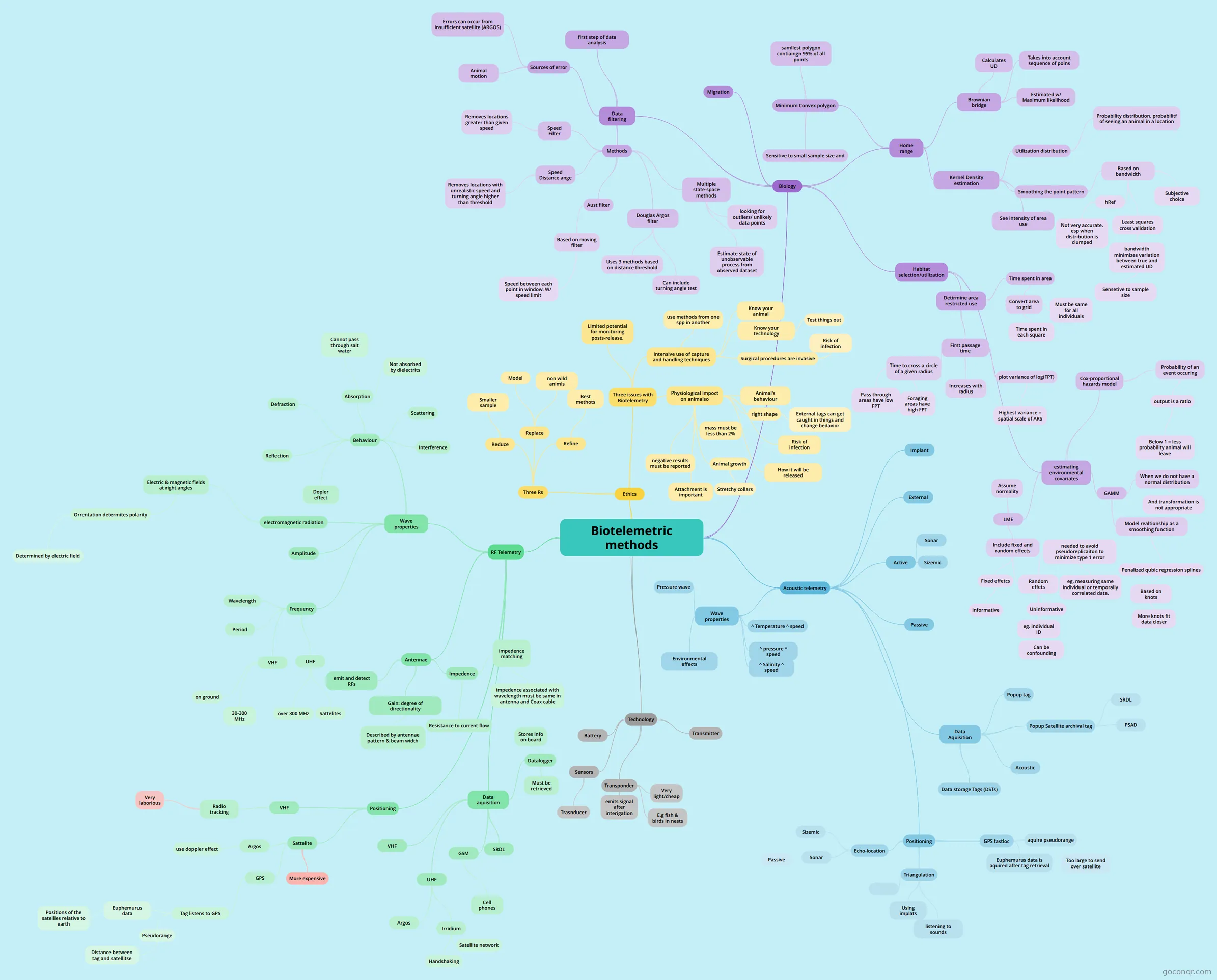
Mind map: Biotelemetric methods
Map content
Biotelemetric methods
Acoustic telemetry
- Implant
- External
- Wave properties
- Pressure wave
- Environmental effects
- ^ Temperature ^ speed
- ^ pressure ^ speed
- ^ Salinity ^ speed
- Passive
- Active
- Sonar
- Sizemic
- Positioning
- Echo-location
- Sonar
- Passive
- Sizemic
- Sonar
- Triangulation
- Using implats
- listening to sounds
- GPS fastloc
- aquire pseudorange
- Too large to send over satellite
- Euphemurus data is aquired after tag retrieval
- aquire pseudorange
- Echo-location
- Data Aquisition
- Popup tag
- Popup Satellite archival tag
- SRDL
- PSAD
- Acoustic
- Data storage Tags (DSTs)
RF Telemetry
- Wave properties
- electromagnetic radiation
- Electric & magnetic fields at right angles
- Orrentation determites polarity
- Determined by electric field
- Orrentation determites polarity
- Electric & magnetic fields at right angles
- Frequency
- Wavelength
- Period
- VHF
- 30-300 MHz
- on ground
- UHF
- over 300 MHz
- Sattelites
- Amplitude
- Behaviour
- Defraction
- Reflection
- Absorption
- Cannot pass through salt water
- Not absorbed by dielectrits
- Scattering
- Interference
- Dopler effect
- electromagnetic radiation
- Antennae
- emit and detect RFs
- Gain: degree of directionality
- Described by antennae pattern & beam width
- Impedence
- Resistance to current flow
- impedence matching
- impedence associated with wavelength must be same in antenna and Coax cable
- Positioning
- VHF
- Radio tracking
- Very laborious
- Radio tracking
- Sattelite
- GPS
- Tag listens to GPS
- Euphemurus data
- Positions of the satellies relative to earth
- Pseudorange
- Distance between tag and satellitse
- Euphemurus data
- Tag listens to GPS
- Argos
- use doppler effect
- More expensive
- GPS
- VHF
- Data aquisition
- VHF
- UHF
- Argos
- Irridium
- Handshaking
- Satellite network
- GSM
- Cell phones
- Datalogger
- Must be retrieved
- Stores info on board
- SRDL
- Wave properties
Ethics
- Three Rs
- Refine
- Best methots
- Replace
- Model
- non wild animls
- Reduce
- Smaller sample
- Refine
- Three issues with Biotelemetry
- Intensive use of capture and handling techniques
- use methods from one spp in another
- Know your animal
- Surgical procedures are invasive
- Risk of infection
- Know your technology
- Test things out
- Physiological impoct on animalso
- mass must be less than 2%
- right shape
- External tags can get caught in things and change bedavior
- Attachment is important
- Animal's behaviour
- Risk of infection
- How it will be released
- negative results must be reported
- Animal growth
- Stretchy collars
- Limited potential for monitoring posts-release.
- Intensive use of capture and handling techniques
- Three Rs
Technology
- Battery
- Sensors
- Trasnducer
- Transmitter
- Transponder
- emits signal after interigation
- E.g fish & birds in nests
- Very light/cheap
Biology
- Home range
- Minimum Convex polygon
- samllest polygon contiaingn 95% of all points
- Sensitive to small sample size and
- Kernel Density estimation
- Utilization distribution
- Probability distribution. probabilitf of seeing an animal in a location
- Smoothing the point pattern
- Based on bandwidth
- hRef
- Not very accurate. esp when distribution is clumped
- Least squares cross validation
- bandwidth minimizes variation between true and estimated UD
- Sensetive to sample size
- bandwidth minimizes variation between true and estimated UD
- Subjective choice
- hRef
- Based on bandwidth
- See intensity of area use
- Utilization distribution
- Brownian bridge
- Calculates UD
- Takes into account sequence of poins
- Estimated w/ Maximum likelihood
- Minimum Convex polygon
- Habitat selection/utilization
- Detirmine area restricted use
- Time spent in area
- Convert area to grid
- Time spent in each square
- Must be same for all individuals
- Convert area to grid
- First passage time
- Time to cross a circle of a given radius
- Pass through areas have low FPT
- Foraging areas have high FPT
- Increases with radius
- plot variance of log(FPT)
- Highest variance = spatial scale of ARS
- Time to cross a circle of a given radius
- Time spent in area
- estimating environmental covariates
- Cox-proportional hazards model
- Probability of an event occuring
- output is a ratio
- Below 1 = less probability animal will leave
- output is a ratio
- Probability of an event occuring
- LME
- Include fixed and random effects
- Fixed effetcs
- informative
- Random effets
- Uninformative
- needed to avoid pseudoreplicaiton to minimize type 1 error
- eg. measuring same individual or temporally correlated data.
- eg. individual ID
- Can be confounding
- Fixed effetcs
- Assume normality
- Include fixed and random effects
- GAMM
- When we do not have a normal distribution
- And transformation is not appropriate
- Model realtionship as a smoothing function
- Penalized qubic regression splines
- Based on knots
- More knots fit data closer
- Based on knots
- Penalized qubic regression splines
- When we do not have a normal distribution
- Cox-proportional hazards model
- Detirmine area restricted use
- Migration
- Data filtering
- first step of data analysis
- Sources of error
- Errors can occur from insufficient satellite (ARGOS)
- Animal motion
- Methods
- Speed Filter
- Removes locations greater than given speed
- Speed Distance ange
- Removes locations with unrealistic speed and turning angle higher than threshold
- Aust filter
- Based on moving filter
- Speed between each point in window. W/ speed limit
- Based on moving filter
- Douglas Argos filter
- Uses 3 methods based on distance threshold
- Can include turning angle test
- Multiple state-space methods
- Estimate state of unobservable process from observed dataset
- looking for outliers/ unlikely data points
- Speed Filter
- Home range