
Mind map
Cartographic Foundations-Map projections
Map content
Cartographic Foundations-Map projections
Mapping projection
- Geoid
- Ellipsoid
- Sphere
- Meridians
- Great Cicles
- Parallels
- Small circles-Equator
- Meridians
Map projection process
- Earth
- Ellipsoid
- sphere
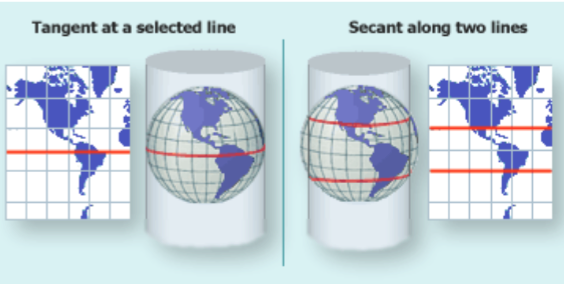
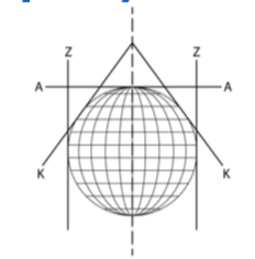
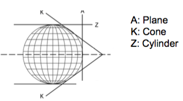
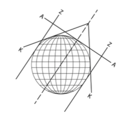
- Cilinder
- Tangent to a selecte line
- Secant along two lines
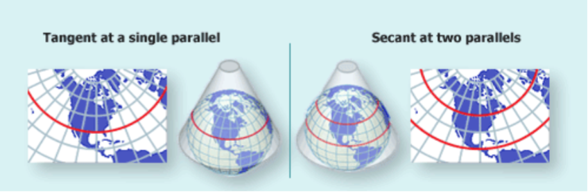
- Cone
- Tangent to a single parallel
- Secant- Two parallels
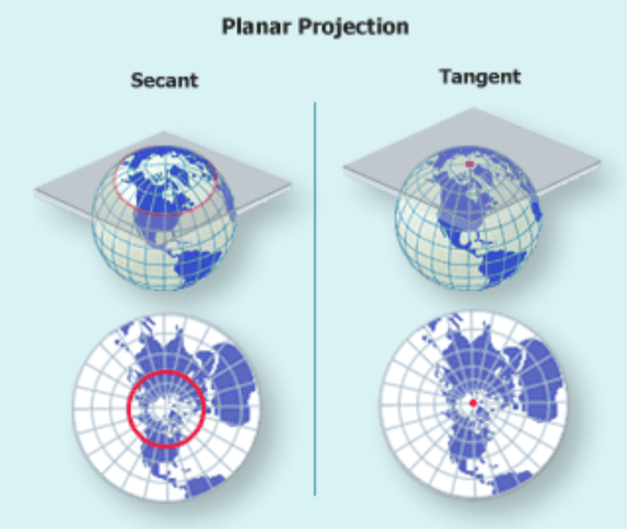
- Plane
- Secant- crossing the earth 2 points no scale distortion
- Tangent to a pole- 1 point no scale distoriton
- Cilinder
- sphere
- Ellipsoid
- Earth
Coordinate systems
- Spherical Coordinate System
- Geographic coordinate system
- Geographic Coordinate System
- Cartesian Coordinate System
- Spherical Coordinate System
Classification of Map Projections
- Distortion Characteristics
- Equal Area
- Same AREA and SIZE. shape distortion
- MOLLWEIDE
- Same AREA and SIZE. shape distortion
- Conformal
- ANGLES and SHAPES preserved. Size and Area distortion
- MERCATOR
- Goal-Navigation
- MERCATOR
- ANGLES and SHAPES preserved. Size and Area distortion
- Equidistance
- TRUE DISTANCES and DIRECTIONS
- Compromise
- Balance projection between the 3 others
- Equal Area
- Aspect
- Normal/Polar Aspect
- Main point on N o S pole
- NO CONVERSION
- Main point on N o S pole
- Equatorial aspect
- Main point lies on the Equator
- Oblique aspect
- Main point at any given point
- Normal/Polar Aspect
- Geometry and Geographical parameter lines
- Normal Projections
- Meridians and parallels are PERPENDICULAR
- AZIMUTHAL N=1
- Perpective projection
- General Azimuthal
- *NORMAL ASPECT * Equal Area or Equidistance *Angles between MERIDIANS are TRUE angles. *Unequal space between PARALLELS
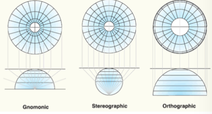
- Central Projection (Gnomic)
- Perpective- ORtodrome a Line *Great circles are straight lines (same as Ortodrome) *STRONG distortion on the boundary * You can't see the equator
- Rhum line- stright
- Orthographic projection
- PARALLEL PROJECTION * Parallels scale true *Strong parallel Compression near the map boundary *One Hemisphere *Astronomical geography
- Astronimical geography
- Stereographic projection
- Conformal *Tissot's indicatrix is a circle everywhere *Positions of Meridians and Parallels are preserved *Strong area distortion in the map boundary
- Conformal- Tissot's indicatrix is a circle everywhere
- General Azimuthal
- Non-Perpective projection
- Azimuthal Equidistant Projection
- No PERPECTIVE. *Meridians and Parallels are EQUIDISTANT. *Small circles are circles. GOOD FOR POLAR REGIONS
- Lambert Azimutal Equal-Area
- Non-Perspective * Parallels spacing DECREASE from the pole and Meridians INCREASE *Topographic map in small scall-One Hemisphere and poles *BEST EQUAL AREA projection for normal with minimun angle distrotion
- Azimuthal Equidistant Projection
- Perpective projection
- CONICAL 0<N<1
- Equidistant conic projection
- CILINDRICAL N=0
- AZIMUTHAL N=1
- PERPENDICULARITY is given by a factor "n"
- n= cos (polar angle)
- Meridians and parallels are PERPENDICULAR
- Pseudo projections
- Meridians and parallels NO PERPEDICULAR
- Normal Projections
- Mapping Geometry
- Perspective projection
- Gnomic
- Stereographic
- Orthographic
- Luz
- Non-perpective projection
- Robinson
- Polyconic
- Special clases
- Interrupted projectiion (UTM)
- Simplified projection
- Compositie projection
- Change projection
- Perspective projection
- Distortion Characteristics
Determining deformation-distortion
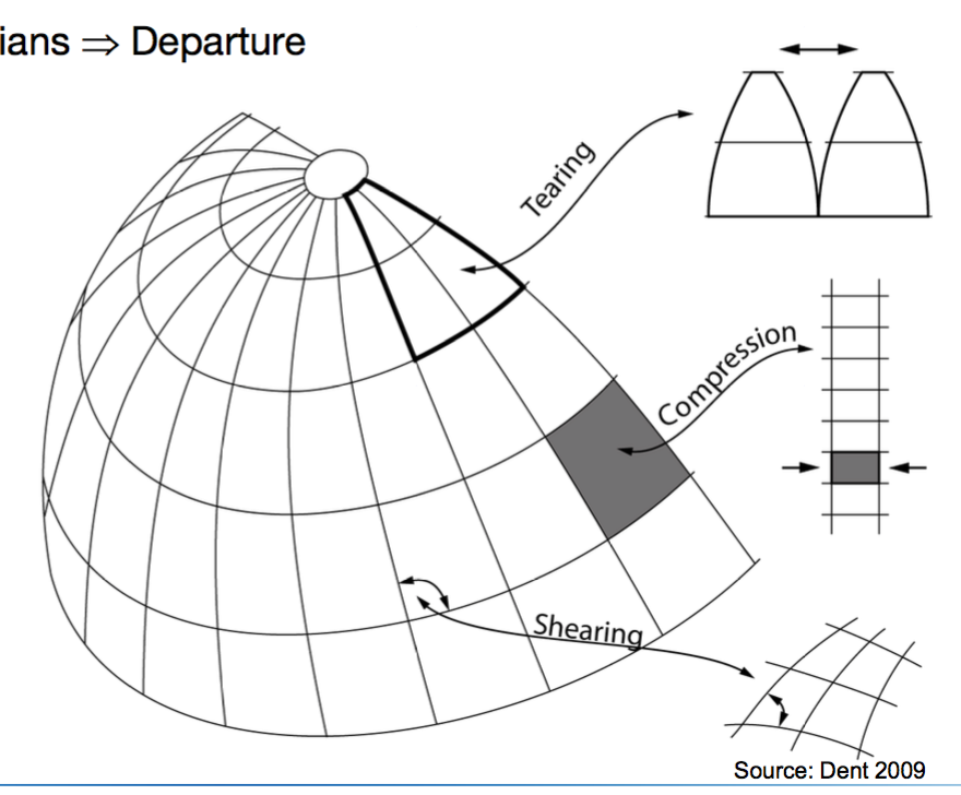
- Deformation due to Departure
- Tearing-descarre
- Compression
- Shearing-Cizallamiento
- First method
- Geometrical figure
- Position a geometrical figure on several locations in the sphere and print the result into de projection graticule
- Cualitative- visual
- Geometrical figure
- Second method
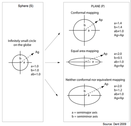
- Tissot's indicatrix
- Quatitative- Higher mathematics
- Infinitesimal radio sphere proyecte with the plane
- Isocoles
- Lines with equal distortion
- Tissot's indicatrix
- Deformation due to Departure
Images and files in the map
Information
- Description
- Geography Mind Map on Cartographic Foundations-Map projections, created by Laura Natalie Barbosa Mejía on 04/02/2017.
- Created by
- Laura Natalie Barbosa Mejía
- Views
- 0
- History
-
- Created by Laura Natalie Barbosa Mejía · Feb 4, 2017
- Copied by Laura Natalie Barbosa Mejía · Feb 4, 2017
- Rating