
Mind map
Cold Environments: Periglacial Processes and Landforms
Map content
Cold Environments: Periglacial Processes and Landforms
Periglacial: Environments experiencing long cold winters and short warm summers, typically with permafrost but not covered by ice (glacial)
Permafrost
- Ground that becomes permanently frozen to depths of over 100 meters.
- Permafrost Table: The upper surface of the permafrost.
- Active Layer: The top few centimetres of soil that may temporarily melt during summer, when temperatures briefly rise above 0 degrees C.
Periglacial Processes
- Frost Shattering and Frost Heave
- Frost Shattering: Water that expands when turned to ice-breaking apart rocks and sediments and forming a rock-strewn landscape called a felsenmeer
- Leads to accumulation of scree at base of cliffs.
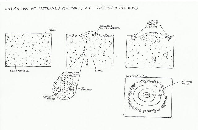
- Frost Heave: Soils become very bumpy and irregular. Freezing soil water just below the surface expands and pushes up the ground above.
- Nivation
- Covers a range of processes associated with snow.
- Includes the effects of frost shattering, which operates around the edges of the snow - gradually causing the underlying rock to disintergrate.
- Meltwater removes any rock debris to reveal an ever enlarging nivation hollow.
- Frost Shattering and Frost Heave
Periglacial Landforms
- Solifluction Lobes
- Downslope movement of rock and soil material in response to gravity.
- Occur in reasonably think and saturated active layer
- Ice Wedges
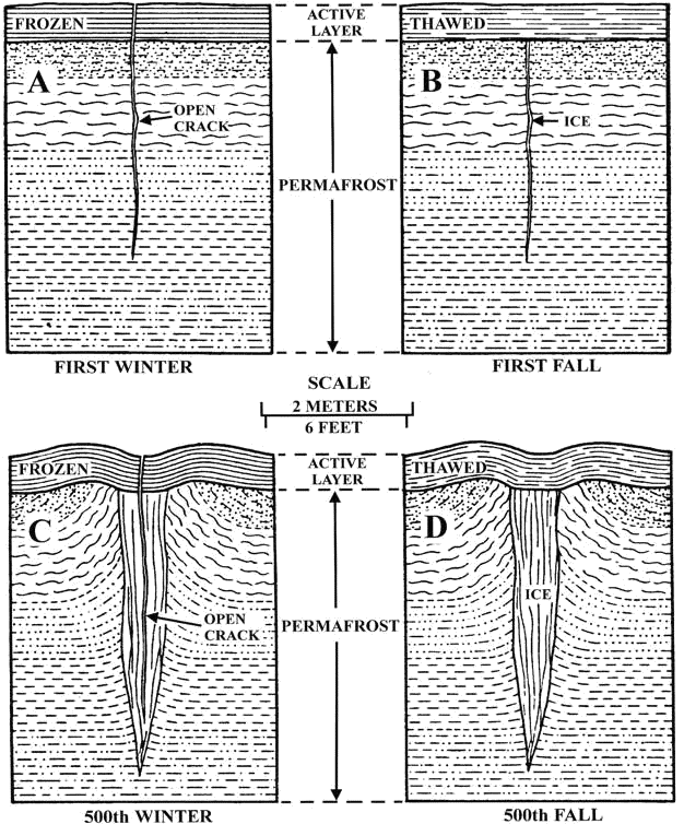
- Meltwater flows into cracks when permafrost contracts. The Meltwater refreezes in the winter to form ice wedges, which expand and force the cracks to widen.
- Influence ground surface by forming narrow ridges - due to frost heave
- Patterned Ground
- As ice wedges become more extensive, a polygonal pattern may be formed on the ground surface-with ice wedges and their ridges marking the sides of the polygons
- Stone Polygons
- Stone Polygons tend to form on shallower slopes, and are directly associated with ice wedges. Frost heave causes expansions of the ground and lifts soil particles upwards.
- Pingos
- Water collects underneath the ground, as the sediment gradually freezes, the water collected becomes trapped and pressurized freezes as well.
- This expansion causes the land to lift, creating a hill or mound
- In the summer, the ice melts and forces the ground above to collapse inwards
- Can be up to 60 meters high, and 600 meters in diameter.
- Solifluction Lobes
Images and files in the map
Information
- Description
- A Levels Geography (Physical Geography-AS) Mind Map on Cold Environments: Periglacial Processes and Landforms, created by Andrew_Ellinas on 09/05/2014.
- Created by
- Andrew_Ellinas
- Views
- 62
- Rating