
Mind map
Plate Tectonics
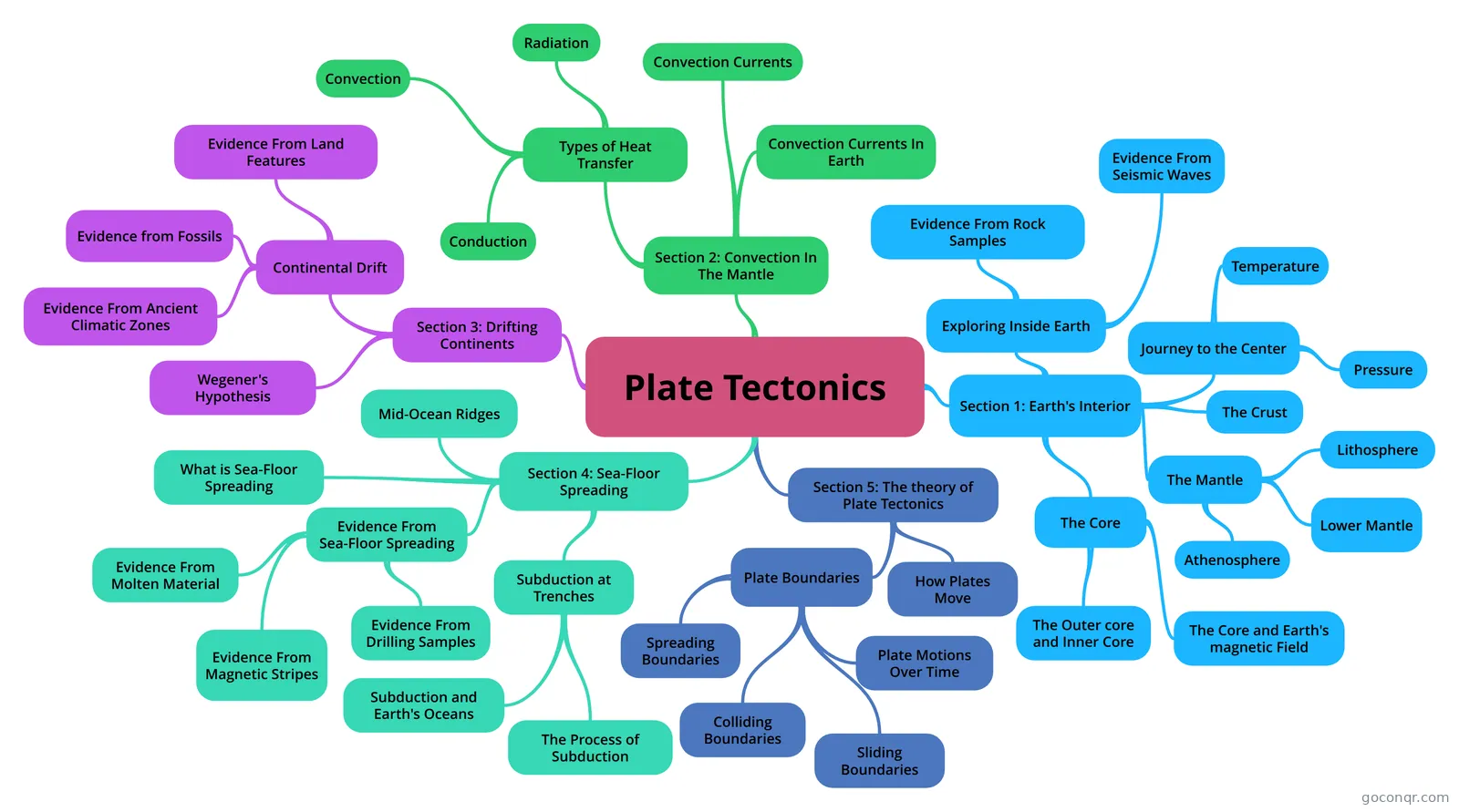
Mind map: Plate tectonics
Map content
Plate Tectonics
Section 1: Earth's Interior
- Exploring Inside Earth
- Evidence from rock samples and seismic waves are used to build a picture of Earth's interior.
- Evidence From Rock Samples
- Scientists drill holes in earth to find evidence from rock samples.
- Evidence From Seismic Waves
- Scientists send waves into Earth's interior to discover it's structure.
- Journey to the Center
- The layers (crust, mantle, and core) vary greatly in size, composition, temperature, and pressure.
- Pressure
- Pressure: the result of force pressing on an area. The deeper you go, the stronger the pressure.
- Temperature
- The deeper inside you go, the higher the temperature. -40 meters= +1 degree Celcius
- The Mantle
- Mantle: A layer of hot rock between the crust and outer core. It's made up of rock that is very hot, but solid. Overall it is 3,000 kilometers thick.
- Lithosphere
- Lithosphere: The uppermost part of the mantle, and right below the crust.
- Lower Mantle
- below the asthenosphere it's solid and extends all the way down to the core.
- Athenosphere
- It's the soft layer of the mantle, and is bendable.
- The Crust
- A layer of solid rock with dry land and ocean land. It can be from 5-70 kilometers thick.
- The Core
- Made up mostly of the metals iron and nickel. In total, the inner core and outer core are 3,486 kilometers thick.
- The Outer core and Inner Core
- Outer Core: a layer of molten metal (liquid) that surrounds the inner core. Inner Core: a dense ball of solid metal made of iron and nickel.
- The Core and Earth's magnetic Field
- Scientists think that movements in the liquid outer core create Earth's magnetic field. The field affects the whole Earth.
- Exploring Inside Earth
Section 2: Convection In The Mantle
- Types of Heat Transfer
- When fluid is heated, the density decreases, and when cooled, the density increases.
- Convection
- Convection: Heat transfer by the movement of currents within a fluid. Density: a measure of how much mass there is in a volume of a substance. heated particles begin to flow and transfer heat from one fluid to another, by difference in temperature and density in a fluid.
- Radiation
- Radiation: Transfer of energy through space. Takes place with no direct contact between a heat source and an object. Ex: the sun and Earth.
- Conduction
- Conduction: Heat transfer within a material or between materials that are touching. Particles near the bottom vibrate faster as they are heated, and when they are bumped into each other, heat transfers.
- Convection Currents
- The flow that transfers heat within a fluid. The warm, less dense air moves upward and floats over the cold er air, and the cold air ids pulled downward by gravity, where it is heated again.
- Convection Currents In Earth
- The rocks in the lower mantle are hotter, and less dense. Solid mantle rock rises, and eventually cools, and sinks back down. This process takes millions of years.
- Types of Heat Transfer
Section 3: Drifting Continents
- Continental Drift
- Continental Drift: When the continents slowly moved over Earth's surface. The continents drifted together to form the supercontinent,Pangea, meaning "all lands".
- Evidence From Land Features
- Coal fields lined up on different continents, and Wegener pieced together the continents and it fit perfectly, so it was a super continent.
- Evidence from Fossils
- Fossil: any trace of a ancient organism that has been preserved in rock. Fossils were found on different continents that are now separated by oceans, bt they couldn't have survived the ocean trip.
- Evidence From Ancient Climatic Zones
- Glaciers were found on the coast of South Africa, near the equator, where it is warm.
- Wegener's Hypothesis
- His hypothesis was rejected, because it did;t explain the force of pushing and pulling along the continents, and it contradicted their ideas on how mountains form. I learned that mountains form when when continents collide, they crumple and fold.
- Continental Drift
Section 4: Sea-Floor Spreading
- Mid-Ocean Ridges
- Mid-ocean ridge: an undersea mountain chain that is part of a long system of mountains that winds beneath the Earth's ocean floor. Sonar: a device that bounces sound waves off underwater objects and than records the echoes of the sound waves.
- What is Sea-Floor Spreading
- Sea-floor spreading: the sea floor spreads apart along both sides of a mid-ocean ridge as new crust is added.
- Subduction at Trenches
- Deep-ocean trenches:under water canyons.
- The Process of Subduction
- Subduction: the process in which the ocean floor sinks beneath a deep-ocean trend and back into the mantle.
- Subduction and Earth's Oceans
- It changes the size and shape of the oceans, and renews the ocean floor about every 2 million years.
- Evidence From Sea-Floor Spreading
- Evidence From Molten Material
- New material is indeed erupting along mid-ocean ridges.Rocks from molten material hardening quickly under water were found along mid-ocean ranges.
- Evidence From Magnetic Stripes
- The magnetic poles reversed themselves 780,000 years ago. They found magnetic stripes that pointed north, which was the alternate of the ones that pointed south.
- Evidence From Drilling Samples
- The farther away from the ridge the rocks were, the older they were, and the ones in the center were always the youngest.
- Evidence From Molten Material
- Mid-Ocean Ridges
Section 5: The theory of Plate Tectonics
- Cracks that break the lithosphere into separate sections called plates.
- How Plates Move
- Plate Tectonics: The theory states that pieces of Earth's lithosphere are in slow, constant motion, driven by convection currents in the mantle. Earthquakes, volcanoes, mountain ranges and deep-ocean trenches are caused by plates moving.
- Plate Boundaries
- Faults: breaks in Earth's crust where rocks have slipped passed each other. Plates move about 1-24 centimeters per years; the Northern American and Eurasian plates move about 2.5 centimeters per year.
- Spreading Boundaries
- Spreading Boundaries: the place where two plates move apart. Ridge Valley: a deep vally that forms along the spreading boundary.
- Sliding Boundaries
- Sliding Boundary: a place where two plates slip past each other, moving in opposite directions.
- Plate Motions Over Time
- Pangea itself formed 260 million years ago. 225 million years ago, Pangea began to break apart.
- Colliding Boundaries
- Colliding Boundaries: the place where two plates come together, or collide. #1: two plates made up of oceanic crust meet at a trench. #2: an oceanic plate collides with a continental plate. #3: two plates carrying continental crust, collide and squeeze the crust into mighty mountain ranges.
Information
- Description
- 6th grade Science (Plate Techtonics) Mind Map on Plate Tectonics, created by Sanjana Nagwekar on 22/09/2015.
- Created by
- Sanjana Nagwekar
- Views
- 7
- Rating