
Geography - Physical Geography Elective
Slides in this set (17)
-
- What is a natural hazard?
- naturally occurring events that threaten human lives and causes damage to property
- Tectonic natural hazard
- caused by plate movements when continental crusts and ocean floors move.
- earthquake
- volcanic eruptions
- Climate-related natural hazard
- caused by severe and extreme weather and climate conditions
- storms
- floods
-
- Core
- mostly iron and nickel
- separated into liquid outer core and solid inner core
- about 3500km thick
- temperature between 3000 and 5000-degree celsius
- Mantle
- mostly solid rock that flow under high temperature and pressure
- 2900km thick
- temperature between 800 and 3000-degree celsius
- Crust
- basalt and granite rocks
- a few km to more than 70km thick
- !! lithosphere - crust & uppermost mantle
- rocks in lithosphere melt
- magma formed
- TYPE OF CRUST
- 1. Oceanic crust
- beneath deep oceans
- between 5 and 8km
- consists mainly basalt, heavy and dense rock formed by cooled magma
- rocks less than 200 million years old
- 2. Continental crust
- beneath earth's continental land masses and under shallow seas close to continents
- between 35 and 70 km
- consists of lighter rocks including granite
- rocks from recently to 4 billion years old
-
- 1. Convection currents
- movements of heat within the mantle.
- materials in the mantle heated by core
- mantle material expand, rise and expand beneath the plates
- -this causes plates to be dragged along
- -and move away from each other
- >hot mantle material cools slightly
- >sink and pull plates along
- -sinking mantle material heats up again near core
- -whole process repeats
- 2. Slab-pull force
- occurs when the dense, sinking oceanic plate at subduction zone pulls the rest of the plate behind it
- -subducting or sinking plate drives downward-moving portion of convection current
- >mantle material away from where plates subduct drives rising portion of convection current
- !! USE "PLATES" INSTEAD OF "CRUST"
- tectonic plates move a few cm a year
-
- 1. DIVERGENT
- Plates move away from each other
- Magma move to surface
- Cools to form new oceanic crust
- 2. CONVERGENT
- Plates move towards each other
- become faulted, folded and sometimes subducted
- 3. TRANSFORM

-
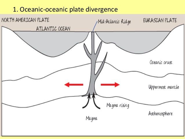
- 1. OCEANIC-OCEANIC PLATE
- when 2 oceanic plates diverge, fractures are formed
- magma rises at zone of divergence to create ridge of new oceanic floor; sea-floor spreading
- when 2 oceanic plates diverge, mid-oceanic ridge is formed
- at various point along MOR, magma builds up and solidify forming undersea volcanoes; shield volcanoes
- when these volcanoes grow above sea level, they are known as volcanic island
- EXAMPLE mid-atlantic ridge: north american plate & eurasian plate
- azores: a chain of volcanic island in north atlantic ridge
- !! youngest rocks are closest to middle of ridge
- why? new crust form continuously. old crust pushed further away from plate boundary
-
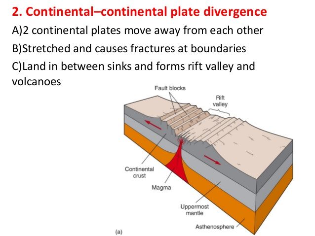
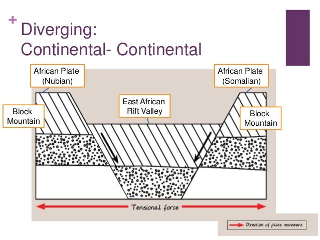
- 2. CONTINENTAL-CONTINENTAL PLATE
- when plates diverge, they are stretched, causing fractures to form; faulting
- when faulting occurs, tensional forces can cause a central block of land to subside between parallel faults, forming rift valley
- block mountains can be formed too
- EXAMPLE east african rift valley: somalian & nubian plate boundary of african plate
- hutt valley, new zealand: australian plate & pacific plate
- black forest, germany: eurasian plate & north american plate
-
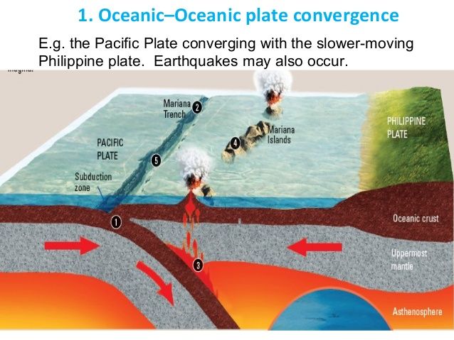
- 1.OCEANIC-OCEANIC PLATE
- when 2 oceanic plates converge & collide, the denser oceanic plate will subduct beneath the less dense oceanic plate; subduction zone
- a deep oceanic trench is formed at the point of subduction
- the subducted ocean plate causes mantle material above it to melt, forming magma
- magma rises through the cracks in the crust and form volcanoes; eventually a chain/arc of island
- earthquake may occur due to friction created
- EXAMPLE mariana island & mariana trench: pacific plate & phillipine plate
-
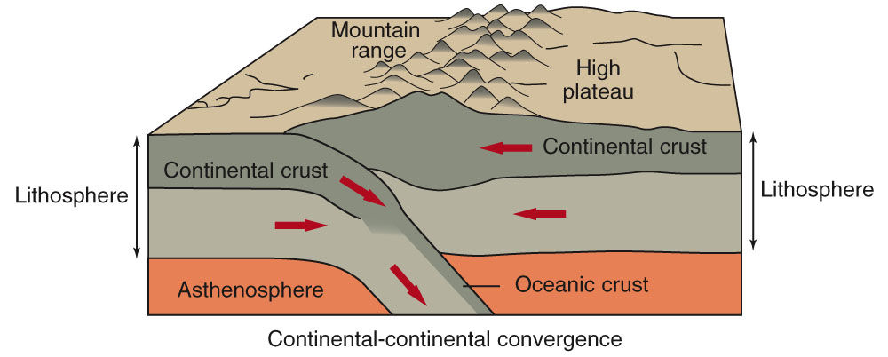
- 2. CONTINENTAL-CONTINENTAL PLATE
- 2 continental plates may collide and push against one another
- they resist subduction because both plates are too thick and buoyant for subduction to occur
- this causes plates to break and slide along fractures in the crust
- layers of rock on the upper part of the crust are then compressed together, they fold sideways/upwards creating fold mountains; folding
- EXAMPLE himalayas: indian plate & eurasian plate
-
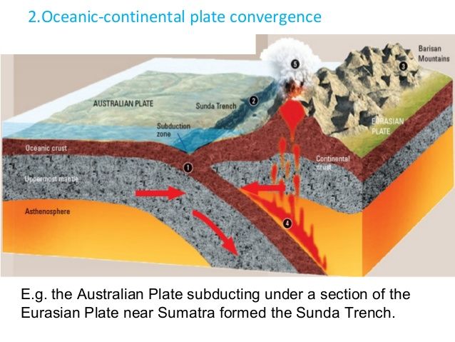
- 3. OCEANIC-CONTINENTAL PLATE
- when an oceanic plate converges with a continental plate, the denser oceanic plate subducts beneath the less dense continental plate
- an oceanic trench is formed at subduction zone
- the edges of continental plate buckles and folds, forming fold mountains
- at subduction zone, sinking plate causes mantle material to melt, forming magma
- magma rises through the cracks, giving rise to volcanic eruptions
- EXAMPLE sunda trench: australian plate & eurasian plate
-
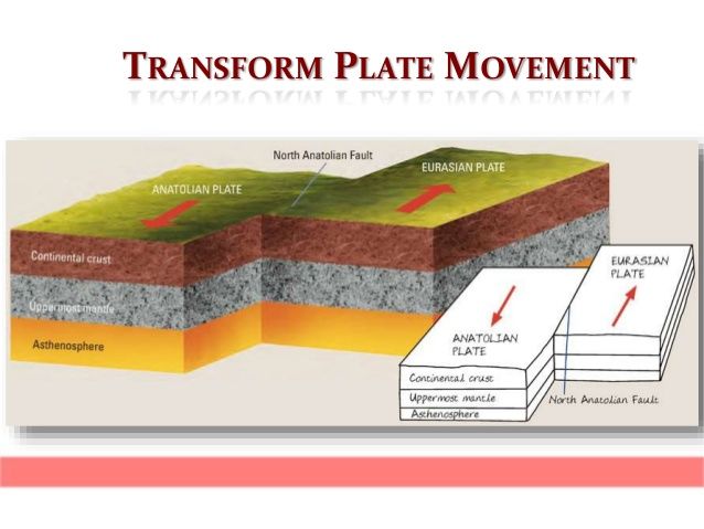
- 1. TRANSFORM
- plates slide past each other along transform plate boundaries
- this results in the formation of a transform fault
- as they do so, tremendous stress builds up
- this stress is eventually released as violent earthquake and tsunami
- EXAMPLE san andreas fault, usa: pacific plate & north american plate
- anatolian fault, turkey: eurasian plate & anatolian plate
-
- 1. DIVERGENT PLATE BOUNDARY
- rift valley
- -a valley formed with steep slope
- -formed along faults
- block mountain
- -a block of land with a steep slope
- -when sections of crust along fault lines sink due to tensional force
-
- 2. CONVERGENT PLATE BOUNDARY
- fold mountains
- -when there is increasing compressional force on 1 limb of a fold, the rocks may buckle until a fracture forms.
- -the limb may then move forward to ride over the other limb
- !! sedimentary rocks: formed from multiple layers of sediments
- igneous rocks: formed when molten rocks cool and solidify
- metamorphic rocks: formed when rocks are charged by high temperatures/ pressure
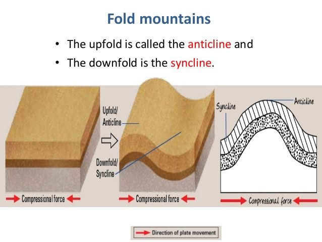
- Caption: syncline- v anticline-A
-
- DEFINITION
- landform formed by magma ejected from the mantle onto the earth's surface
- TYPES
- shield volcano
- -low silica, low viscosity
- -gently sloping sides, wide summit
- -non-explosive (gas escapes easily)
- EXAMPLE mount washington
- !! flows over long distance
- stratovolcano volcano
- -high silica, high viscosity
- -steeper at top, gentler at base
- -explosive (traps gas) ; pyroclastic flow, lahars
- EXAMPLE mount pinatubo
- !! flows over short distance + ash
- ?? viscosity: stickiness of the lava/ its resistance to flow
-
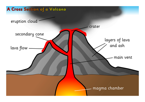
- FORMATION
- more magma seeps into magma chamber, amount of pressure in chamber builds up giving rise to volcanic eruption
- when stratovolcano erupts, pyroclasts are released; force of volcanic eruption depends on amount of pressure being built up
- new eruption of lava covers pyroclasts and builds up volcano
- lava builds up around the vent, solidifying to form a small volcanic cone; crater
- during formation, vent may become blocked; secondary cone develops as magma is forced to find new exit route
- summit of volcano may be blown off during an explosive eruption; sides of crater collapse inwards due to loss of structural support; caldera
-
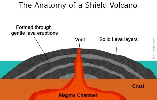
- formed where low silica lava ejected
- low silica lava less viscous and flows easily, spreading out over larger area
- results in gently sloping sides and broad summit
- less viscuos, does not trap much gas, not explosive
- divergent plate boudaries
- EXAMPLE mount washington, usa
-
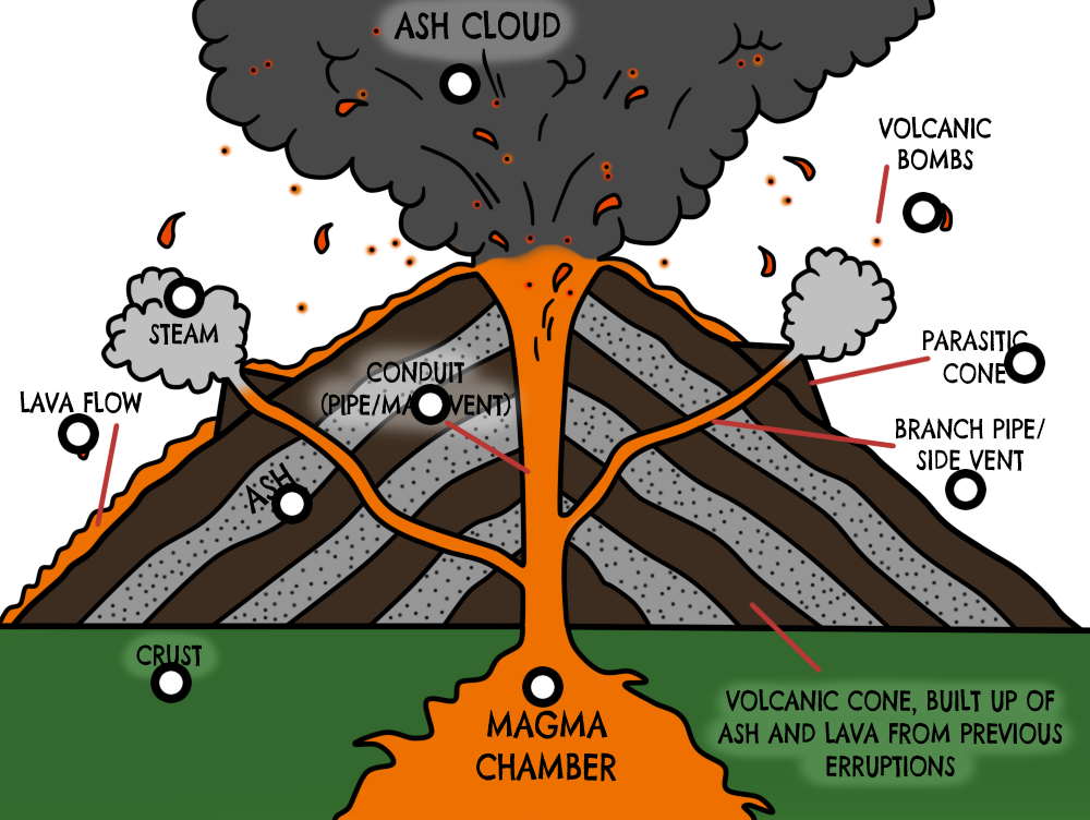
- formed where high silica lava ejected
- high silica lava more viscous and traps heat more easily
- results in pressure building up
- as magma rises to surface, gases able to expand, causing outward explosion
- eruption ejects lava and pyroclasts
- successive erueption builds high volcano
- with steeper side and gentler base
- when pyroclasts mix with super heated gases; pyroclastic flow, 200m/sec
- pyroclasts mix with water; lahars, fast flowing muflow, 40m/sec
- EXAMPLE mount pinatubo, philippines, 1991, 10m tonnes of lava and 20m tonnes of ash
- mount merapi, indonesia
-
- most earthquake and volcanic eruption; pacific ring of fire
- PROF found along convergent plate boundary
- volcanoes not only PROF but also other places like atlantic ocean and east africa
- hence, there is a close correlation between locations of plate boundaries and distribution of major active volcanoes
Information
- Description
- Our Dynamic Planet
- Created by
- Winni Lim · Sep 2017
- Updated
- Sep 8, 2017
- Views
- 392
- Tags
- Rating