
Mapa mental
World at risk
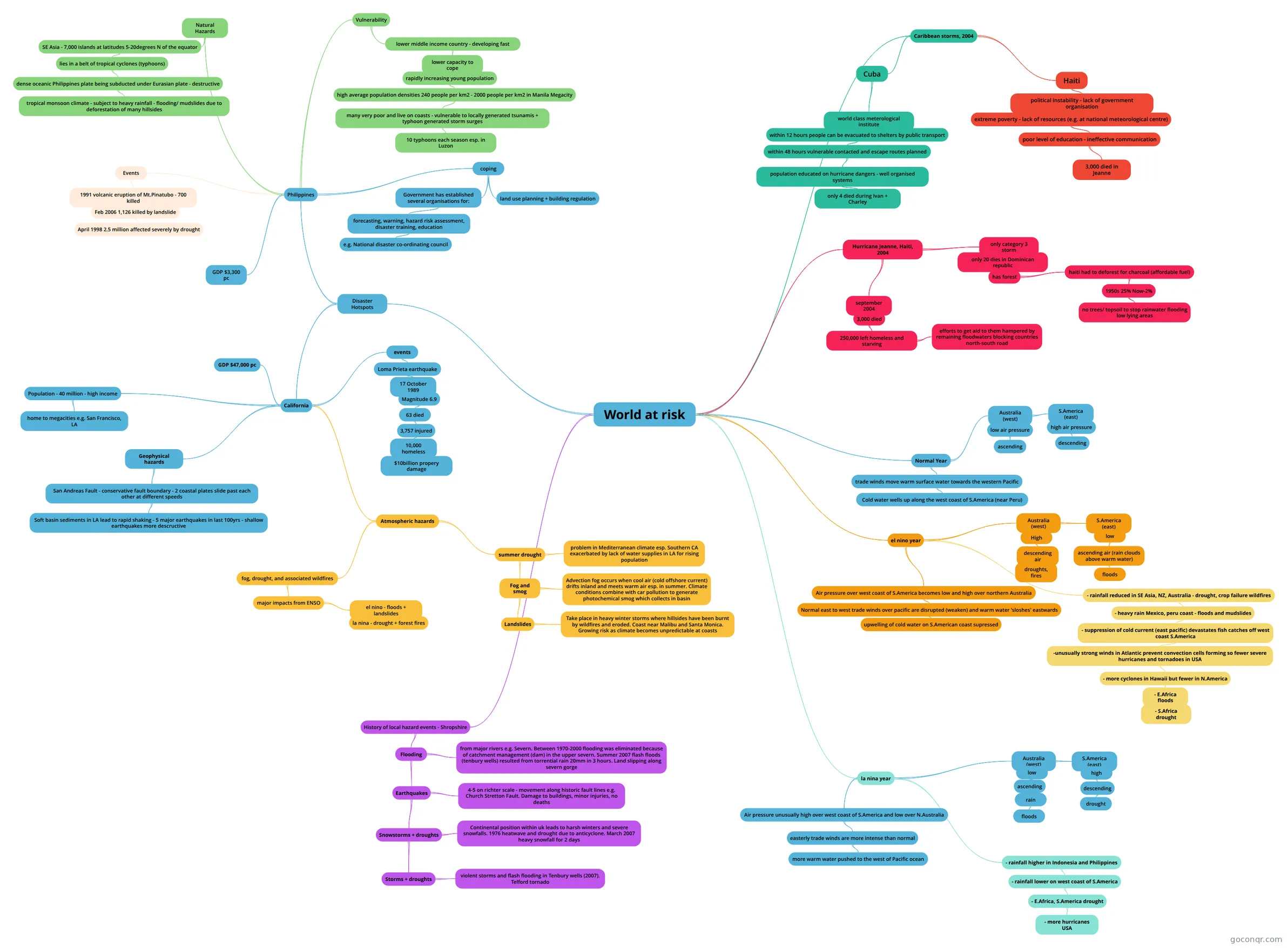
Mind map: World at risk
Conteúdo do mapa
World at risk
Normal Year
- trade winds move warm surface water towards the western Pacific
- Cold water wells up along the west coast of S.America (near Peru)
- Australia (west)
- S.America (east)
- high air pressure
- descending
- high air pressure
- low air pressure
- ascending
- S.America (east)
- trade winds move warm surface water towards the western Pacific
el nino year
- Air pressure over west coast of S.America becomes low and high over northern Australia
- Normal east to west trade winds over pacific are disrupted (weaken) and warm water 'sloshes' eastwards
- upwelling of cold water on S.American coast supressed
- Normal east to west trade winds over pacific are disrupted (weaken) and warm water 'sloshes' eastwards
- Australia (west)
- S.America (east)
- low
- ascending air (rain clouds above warm water)
- floods
- ascending air (rain clouds above warm water)
- low
- High
- descending air
- droughts, fires
- descending air
- S.America (east)
- - rainfall reduced in SE Asia, NZ, Australia - drought, crop failure wildfires
- - heavy rain Mexico, peru coast - floods and mudslides
- - suppression of cold current (east pacific) devastates fish catches off west coast S.America
- -unusually strong winds in Atlantic prevent convection cells forming so fewer severe hurricanes and tornadoes in USA
- - more cyclones in Hawaii but fewer in N.America
- - E.Africa floods
- - S.Africa drought
- - E.Africa floods
- - more cyclones in Hawaii but fewer in N.America
- -unusually strong winds in Atlantic prevent convection cells forming so fewer severe hurricanes and tornadoes in USA
- - suppression of cold current (east pacific) devastates fish catches off west coast S.America
- - heavy rain Mexico, peru coast - floods and mudslides
- Air pressure over west coast of S.America becomes low and high over northern Australia
la nina year
- Air pressure unusually high over west coast of S.America and low over N.Australia
- easterly trade winds are more intense than normal
- more warm water pushed to the west of Pacific ocean
- easterly trade winds are more intense than normal
- Australia (west)
- S.America (east)
- high
- descending
- drought
- descending
- high
- low
- ascending
- rain
- floods
- rain
- ascending
- S.America (east)
- - rainfall higher in Indonesia and Philippines
- - rainfall lower on west coast of S.America
- - E.Africa, S.America drought
- - more hurricanes USA
- - E.Africa, S.America drought
- - rainfall lower on west coast of S.America
- Air pressure unusually high over west coast of S.America and low over N.Australia
Hurricane Jeanne, Haiti, 2004
- september 2004
- 3,000 died
- 250,000 left homeless and starving
- efforts to get aid to them hampered by remaining floodwaters blocking countries north-south road
- 250,000 left homeless and starving
- 3,000 died
- only category 3 storm
- only 20 dies in Dominican republic
- has forest
- haiti had to deforest for charcoal (affordable fuel)
- 1950s 25% Now-2%
- no trees/ topsoil to stop rainwater flooding low lying areas
- 1950s 25% Now-2%
- haiti had to deforest for charcoal (affordable fuel)
- has forest
- only 20 dies in Dominican republic
- september 2004
Caribbean storms, 2004
- Cuba
- world class meterological institute
- within 12 hours people can be evacuated to shelters by public transport
- within 48 hours vulnerable contacted and escape routes planned
- population educated on hurricane dangers - well organised systems
- only 4 died during Ivan + Charley
- population educated on hurricane dangers - well organised systems
- within 48 hours vulnerable contacted and escape routes planned
- within 12 hours people can be evacuated to shelters by public transport
- world class meterological institute
- Haiti
- political instability - lack of government organisation
- extreme poverty - lack of resources (e.g. at national meteorological centre)
- poor level of education - ineffective communication
- 3,000 died in Jeanne
- poor level of education - ineffective communication
- extreme poverty - lack of resources (e.g. at national meteorological centre)
- political instability - lack of government organisation
- Cuba
Disaster Hotspots
- Philippines
- Natural Hazards
- SE Asia - 7,000 islands at latitudes 5-20degrees N of the equator
- lies in a belt of tropical cyclones (typhoons)
- dense oceanic Philippines plate being subducted under Eurasian plate - destructive
- tropical monsoon climate - subject to heavy rainfall - flooding/ mudslides due to deforestation of many hillsides
- dense oceanic Philippines plate being subducted under Eurasian plate - destructive
- lies in a belt of tropical cyclones (typhoons)
- SE Asia - 7,000 islands at latitudes 5-20degrees N of the equator
- Vulnerability
- lower middle income country - developing fast
- lower capacity to cope
- rapidly increasing young population
- high average population densities 240 people per km2 - 2000 people per km2 in Manila Megacity
- many very poor and live on coasts - vulnerable to locally generated tsunamis + typhoon generated storm surges
- 10 typhoons each season esp. in Luzon
- many very poor and live on coasts - vulnerable to locally generated tsunamis + typhoon generated storm surges
- high average population densities 240 people per km2 - 2000 people per km2 in Manila Megacity
- rapidly increasing young population
- lower capacity to cope
- lower middle income country - developing fast
- coping
- Government has established several organisations for:
- forecasting, warning, hazard risk assessment, disaster training, education
- e.g. National disaster co-ordinating council
- forecasting, warning, hazard risk assessment, disaster training, education
- land use planning + building regulation
- Government has established several organisations for:
- Events
- 1991 volcanic eruption of Mt.Pinatubo - 700 killed
- Feb 2006 1,126 killed by landslide
- April 1998 2.5 million affected severely by drought
- Feb 2006 1,126 killed by landslide
- 1991 volcanic eruption of Mt.Pinatubo - 700 killed
- GDP $3,300 pc
- Natural Hazards
- California
- Population - 40 million - high income
- home to megacities e.g. San Francisco, LA
- Geophysical hazards
- San Andreas Fault - conservative fault boundary - 2 coastal plates slide past each other at different speeds
- Soft basin sediments in LA lead to rapid shaking - 5 major earthquakes in last 100yrs - shallow earthquakes more descructive
- San Andreas Fault - conservative fault boundary - 2 coastal plates slide past each other at different speeds
- events
- Loma Prieta earthquake
- 17 October 1989
- Magnitude 6.9
- 63 died
- 3,757 injured
- 10,000 homeless
- $10billion propery damage
- 10,000 homeless
- 3,757 injured
- 63 died
- Magnitude 6.9
- 17 October 1989
- Loma Prieta earthquake
- Atmospheric hazards
- fog, drought, and associated wildfires
- major impacts from ENSO
- el nino - floods + landslides
- la nina - drought + forest fires
- el nino - floods + landslides
- major impacts from ENSO
- summer drought
- problem in Mediterranean climate esp. Southern CA exacerbated by lack of water supplies in LA for rising population
- Fog and smog
- Advection fog occurs when cool air (cold offshore current) drifts inland and meets warm air esp. in summer. Climate conditions combine with car pollution to generate photochemical smog which collects in basin
- Landslides
- Take place in heavy winter storms where hillsides have been burnt by wildfires and eroded. Coast near Malibu and Santa Monica. Growing risk as climate becomes unpredictable at coasts
- fog, drought, and associated wildfires
- GDP $47,000 pc
- Population - 40 million - high income
- Philippines
History of local hazard events - Shropshire
- Flooding
- from major rivers e.g. Severn. Between 1970-2000 flooding was eliminated because of catchment management (dam) in the upper severn. Summer 2007 flash floods (tenbury wells) resulted from torrential rain 20mm in 3 hours. Land slipping along severn gorge
- Earthquakes
- 4-5 on richter scale - movement along historic fault lines e.g. Church Stretton Fault. Damage to buildings, minor injuries, no deaths
- Snowstorms + droughts
- Continental position within uk leads to harsh winters and severe snowfalls. 1976 heatwave and drought due to anticyclone. March 2007 heavy snowfall for 2 days
- Storms + droughts
- violent storms and flash flooding in Tenbury wells (2007). Telford tornado
- Flooding
Informações
- Descrição
- Mapa Mental sobre World at risk, criado por laurenclark90 em 06-05-2015.
- Criado por
- laurenclark90
- Visualizações
- 1
- Avaliação