
Mind map
Geology
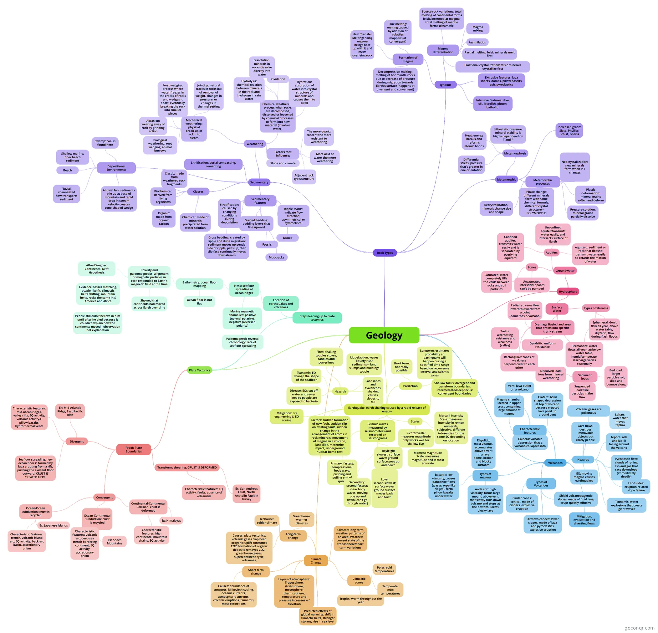
Mind map: Geology
Map content
Geology
Plate Tectonics
- Steps leading up to plate tectonics:
- Location of earthquakes and volcanoes
- Hess: seafloor spreading at ocean ridges
- Bathymetry: ocean floor mapping
- Polarity and paleomagnetics: alignment of magnetic particles in rock responded to Earth's magnetic field at the time
- Alfred Wegner: Continental Drift Hypothesis
- Evidence: fossils matching, puzzle-like fit, climactic belts shifting, mountain belts, rocks the same in S America and Africa
- People still didn't believe in him until after he died because it couldn't explain how the continents moved-- observation not explanation
- Evidence: fossils matching, puzzle-like fit, climactic belts shifting, mountain belts, rocks the same in S America and Africa
- Showed that continents had moved across Earth over time
- Alfred Wegner: Continental Drift Hypothesis
- Ocean floor is not flat
- Polarity and paleomagnetics: alignment of magnetic particles in rock responded to Earth's magnetic field at the time
- Marine magnetic anomalies: positive (normal polarity), negative (reversed polarity)
- Paleomagnetic reversal chronology: rate of seafloor spreading
- Bathymetry: ocean floor mapping
- Hess: seafloor spreading at ocean ridges
- Location of earthquakes and volcanoes
- Proof: Plate Boundaries
- Divergent
- Seafloor spreading: new ocean floor is formed by lava erupting from a rift, pushing the existent floor outward. CRUST IS CREATED HERE.
- Characteristic features: mid-ocean ridges, valley rifts, EQ activity, volcanic activity-> pillow basalts, hydrothermal vents
- Ex: Mid-Atlantic Ridge, East Pacific Rise
- Convergent
- Ocean-Ocean Subduction: crust is recycled
- Characteristic features: trench, volcanic island arc, EQ activity, back-arc basin, accretionary prism
- Ex: Japanese Islands
- Ocean-Continental Subduction: crust is recycled
- Characteristic features: volcanic arc, deep sea trench bordering continent, EQ activity, accretionary prism
- Ex: Andes Mountains
- Continental-Continental Collision: crust is deformed
- Characteristic features: high continental mountain chains, EQ activity
- Ex: Himalayas
- Ocean-Ocean Subduction: crust is recycled
- Transform: shearing, CRUST IS DEFORMED
- Characteristic features: EQ activity, faults, absence of volcanism
- Ex: San Andreas Fault, North Anatolin Fault in Turkey
- Divergent
- Steps leading up to plate tectonics:
Rock Types
- Sedimentary
- Weathering
- Mechanical weathering: physical break-up of rock into pieces
- Jointing: natural cracks in rocks b/c of removal of weight, changes in pressure, or changes in thermal setting
- Frost wedging: process where water freezes in the cracks of rocks and wedges it apart, eventually breaking the rock into smaller pieces
- Abrasion: wearing away of rock by grinding action
- Biological weathering: root wedging, animal burrows
- Chemical weathering: process when rocks are decomposed, dissolved or loosened by chemical processes to form into new material (involves water)
- Hydrolysis: chemical reaction between minerals in the rock and hydrogen in rain water
- Dissolution: minerals in rocks dissolve directly into water
- Oxidation
- Hydration: absorption of water into crystal structure of minerals and causes them to swell
- Factors that influence:
- The more quartz content the more resistant to weathering
- More acid of water the more weathering
- Adjacent rock type/structure
- Slope and climate
- Mechanical weathering: physical break-up of rock into pieces
- Lithification: burial compacting, cementing
- Classes
- Clastic: made from weathered rock fragments
- Biochemical: derived from living organisms
- Organic: made from organic carbon
- Chemical: made of minerals precipitated from water solution
- Sedimentary features
- Stratification: caused by changing conditions during deposistion
- Cross bedding: created by ripple and dune migration; sediment moves up gentle side of ripple, piles up, then slip face continually moves downstream
- Graded bedding: bedding layers that fine upward
- Fossils
- Ripple Marks: indicate flow direction; asymmetrical or symmetrical
- Dunes
- Mudcracks
- Depositional Environments
- Alluvial fan: sediments pile up at base of mountain and rapid drop in stream velocity creates cone-shaped wedge
- Fluvial: channelized flow transports sediment
- Beach
- Shallow marine: finer beach sediment
- Swamp: coal is found here
- Weathering
- Igneous
- Formation of magma
- Heat Transfer Melting: rising magma brings heat up with it and melts overlying rock
- Flux melting: melting caused by addition of volatiles (happens at convergent)
- Decompression melting: melting of hot mantle rocks due to decrease of pressure during migration towards Earth's surface (happens at divergent and convergent)
- Magma differentiation
- Source rock variations: total melting of continental forms felsic/intermediat magma, total melting of mantle forms ultramafic
- Magma mixing
- Assimilation
- Partial melting: felsic minerals melt first
- Fractional crystallization: felsic minerals crystallize first
- Extrusive features: lava sheets, domes, pillow basalts, ash, pyroclastics
- Intrusive features: dike, sill, laccolith, pluton, batholith
- Formation of magma
- Metamorphic
- Metamorphosis
- Heat: energy breaks and reforms atomic bonds
- Lithostatic pressure: mineral stability is highly dependend on T and P
- Differential stress: pressure that's greater in one orientation
- Metamorphic processes
- Recrystallization: minerals change size and shape
- Phase change: different minerals form with same chemical formula, different crystal structure-> POLYMORPHS
- Pressure solution: mineral grains partially dissolve
- Plastic deformation: mineral grains soften and deform
- Neocrystallization: new minerals form when P-T changes
- Increased grade: Slate, Phyllite, Schist, Gneiss
- Metamorphosis
- Sedimentary
Earthquake: earth shaking caused by a rapid release of energy
- Factors: sudden formation of new fault, sudden slip on existing fault, sudden change in the arrangement of atoms in rock minerals, movement of magma in a volcano, landslide, meteorite impact, underground nuclear bomb test
- Seismic waves measured by seismometers and recorded on seismograms
- Primary: fastest; compressional body wave; pushing and pulling end of spring
- Secondary: second-fastest; shear body waves; moving rope up and down (can't go through water)
- Love: second-slowest; surface wave; ground surface moves back and forth
- Rayleigh: slowest; surface wave; ground surface goes up and down
- Scales
- Mercalli Intensity Scale: measures intensity in roman numerals, subjective, different intesenties for the same EQ depending on location
- Richter Scale: measures magnitude, only works well for shallow EQs
- Moment Magnitude Scale: measures magnitude and is most accurate
- Shallow focus: divergent and transform boundaries, Intermediate/Deep focus: convergent boundaries
- Hazards
- Landslides and Avalanches: shaking causes slopes to fail
- Liquefaction: waves liquefy H2O sediments-> land slumps and buildings topple
- Fires: shaking topples stoves, candles and powerlines
- Tsunamis: EQ change the shape of the seafloor
- Disease: EQs cut off water and sewer lines so people are exposed to bacteria
- Prediction
- Short term: not really possible
- Longterm: estimates probability an earthquake will happen during a specified time range based on recurrence interval and seismic zones
- Mitigation: EQ engineering & EQ zoning
Volcanoes
- Types of magma
- Basaltic: low viscosity, causes pahoehoe flows (glassy, rope-like ridges), form pillow basalts under water
- Andesitic: high viscosity, forms large mound above vent that slowly runs down volcano and stops at the bottom. Forms blocky lava
- Rhyolitic: most viscous, accumulates above a vent in a lava dome, broken and blocky surfaces
- Characteristic features
- Magma chamber: located in upper crust containing large amount of magma
- Vent: lava outlet on a volcano
- Craters: bowl shaped depression at top of volcano because erupted lava piled up around vent
- Caldera: volcanic depression that a volcano collapses into
- Types of Volcanoes
- Cinder cones: conical, made of cinders, explosive eruption
- Stratovolcanoes: lower slopes, made of lava and pyroclastics, explosive eruption
- Shield volcanoes:gentle slopes, made of fluid lava, erupt quietly, effusive
- Hazards
- Lava flows: destroys immovable objects but rarely people
- Tephra: ash and lapilli falling around the volcano
- Lahars: water that moves tephra
- Pyroclastic flow: clouds of rolling ash and gas that race downslope (immediately deadly)
- Landslides: eruption-related slope faliure
- EQ: moving magma causes earthquakes
- Tsunamis: water explosions that create giant waves
- Volcanic gases are poisonous
- Mitigation: evacuation and diverting flows
- Types of magma
Hydrosphere
- Surface Water
- Drainage Basin: land area that drains into specific trunk stream
- Dendritic: uniform resistance
- Trellis: alternating resistance and weakness (valley)
- Rectangular: zones of weakness perpendicular to each other
- Radial: streams flow inward/outward from a point (dome/basin/volcano)
- Types of Streams
- Permanent: water flows all year, at/below water table, humid/temperate, discharge varies seasonally
- Ephemeral: don't flow all year, above water table, dry/arid, flow during flash floods
- Sediment loads
- Dissolved load: ions from mineral weathering
- Suspended load: fine particles in the flow
- Bed load: larger particles roll, slide and bounce along
- Drainage Basin: land area that drains into specific trunk stream
- Groundwater
- Zones
- Unsaturated: interstitial spaces can't be pumped
- Saturated: water completely fills the voids between rocks and soil particles
- Aquifers
- Confined aquifer: transmits water easily and is separated by overlying aquitard
- Unconfined aquifer:transmits water easily, and intersects surface of Earth
- Aquitard: sediment or rock that doesn't transmit water easily so retards the motion of water
- Zones
- Surface Water
Climate Change
- Climate: long term weather patterns of an area; Weather: current state of the troposphere/short term variations
- Climactic zones
- Tropics: warm throughout the year
- Temperate: mild temperatures
- Polar: cold temperatures
- Layers of atmosphere: Troposphere, stratosphere, mesosphere, thermosphere; temperature and pressure increases w/ elevation
- Long-term change
- Greenhouse: warmer climates
- Icehouse: colder climate
- Causes: plate tectonics, volcanic gases trap heat, orogenic uplift consumes CO2, formation of organic deposits removes CO2, greenhouse gases, supercontinent cycle, volcanoes,
- Short term change
- Causes: abundance of sunspots, Milkovitch cycling, oceanic currents, atmospheric currents, volcanic eruptions, tsunamis, mass extinctions
- Predicted effects of global warming: shift in climactic belts, stronger storms, rise in sea level
Information
- Description
- Mind Map on Geology, created by sehicks on 02/05/2014.
- Created by
- sehicks
- Views
- 22
- Rating